Airborne Electromagnetics Surveys
Page last updated:16 July 2021
AusAEM Surveys
AusAEM is an ongoing series of wide line-spacing (20 km) AEM surveys across Australia. AusAEM1 and AusAEM2, and AusAEM20 were conducted as part of the Exploring for the Future program, aiming to facilitate sedimentary cover thickness mapping and groundwater resource characterisation. Further details, and links to the datasets.
2016 Southern Thomson VTEMTMPlus AEM survey
The 2016 Southern Thomson Orogen VTEMTMPlus AEM Survey was funded by Geoscience Australia as part of a collaborative project between the Commonwealth of Australia (Geoscience Australia) and its partners - the State of New South Wales (Department of Planning and Environment, Geological Survey of New South Wales) and the State of Queensland (Department of Natural Resources and Mines, Geological Survey of Queensland). The project aims to better understand the geological character and mineral potential of the southern Thomson Orogen region, focusing on the border between New South Wales and Queensland, by acquiring and interpreting multi-disciplinary geophysical, geochemical and geological data. The primary intended impact of this work is to provide the mineral exploration industry with pre-competitive data and knowledge that reduces risk and encourages mineral exploration in the region.
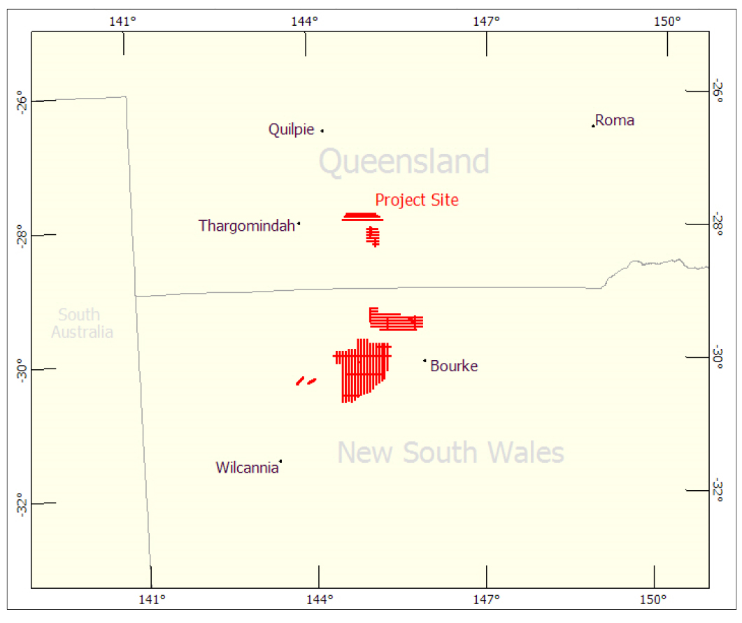
Locality diagram for Phase 2 of the Southern Thomson VTEMTMPlus AEM Survey as flown by Geotech Airborne Pty Ltd.
Geoscience Australia contracted Geotech Airborne Pty Ltd to acquire VTEMTMPlus AEM data over part of the Southern Thomson Orogen in Queensland and New South Wales in May and June 2016.The data were also processed by Geotech Airborne Ltd using its FullWaveForm® processing techniques.
The survey area consists of 2424 line km of time-domain AEM geophysical data acquired in five survey blocks. The majority of traverse lines were flown in an east-west direction and spaced at 5000 m, further details about the flight line specifications of each block can be found in Table 1.
The original data supplied by Geotech Airborne Pty Ltd has been modified to contain the final data fields of principal interest, enabling a manageable data file size. These data are available from Geoscience Australia's website free of charge. The comprehensive dataset is available from Geoscience Australia by emailing mineralgeophysics@ga.gov.au.
The data release package includes:
- Point-located electromagnetic dB/dt and derived B-field data with associated position, altimeter, orientation, and derived ground elevation data. These data are in ASCII column format with associated README and ASEG-GDF2 header files. The dataset consists of separate download files for the:
- Survey Lines
- Repeat lines
- Waveform files for every flight containing the 192 kHz sampling of the transmitter current and receiver waveforms.
- Point-located conductivity estimates derived using the EM Flow® conductivity depth imaging (CDI) algorithm with associated position, altimeter, orientation, magnetic gradiometer, and derived ground elevation data. Data include the conductivity estimate for each 5 m interval and selected depth slices.
- Gridded data, at 1 km cell size, for the conductivity depth slices derived from the EM Flow® CDI data, magnetics and elevation data in ER Mapper® binary raster grid format with associated header files.
- Graphical multiplots, in PDF format, for each flight line showing EM Flow® CDI sections and profiles of Z-component dB/dt data, magnetics, powerline monitor, height and orientation data.
- Contractor supplied Operations Report.
- ESRI shapefiles and KML files of flight lines.
- Metadata and License files.
Table 1. Survey specifications as supplied from the Geotech Airborne Pty Ltd.
| Survey Block | Line Spacing (m) | Area (km2) | Planned Line-km | Actual Line-km | Flight direction | Line numbers |
|---|---|---|---|---|---|---|
| East-west | Traverse:5000 | 996 | 996 | N 90° E / N 270° E | L5000-L5170 | |
| Traverse:5000 | N 90° E / N 270° E | L6000-6070 | ||||
| Traverse:8500-30000 | N 90° E / N 270° E | L7000-L7030 & L7220 | ||||
| Traverse:2500-5000 | N 90° E / N 270° E | L8000-L8030 | ||||
| North-south | Traverse:1500-8500 | 9791 | 1373 | 1373 | N 0° E / N 180° E | L5060-L5080 |
| Traverse:29000-45000 | N 0° E / N 180° E | L6080-L6100 | ||||
| Traverse:5000 | N 0° E / N 180° E | L7040-L7210 | ||||
| Southeast-northwest | n/a | 15.5 | 15.5 | N 130° E / N 310° E | L6110 | |
| Southwest-northwest | n/a | 14.9 | 14.9 | N 60° E / N 240° E | L7230 | |
| n/a | 15.2 | 15.2 | N 40° E / N 220° E | L7240 | ||
| Reflight from AA140005 | n/a | 9 | N 0° E / N 180° E | L1311 | ||
| TOTAL | 9791 | 2415 | 2424 | |||
2016 Lawn Hill VTEMTMPlus AEM survey
The 2016 Lawn Hill VTEMTMPlus AEM survey was funded under the Queensland Government's Future Resources (Mount Isa Geophysics) Initiative and managed by Geoscience Australia on behalf of the Geological Survey of Queensland. The survey covers an area of covers an area of 3215 km2 and is an extension to the 2016 East Isa VTEMTMPlus Survey (eCAT:104700) which aims to attract explorers into 'greenfield' terranes and contribute to the discovery of the next generation of major mineral and energy deposits under shallow sedimentary cover.
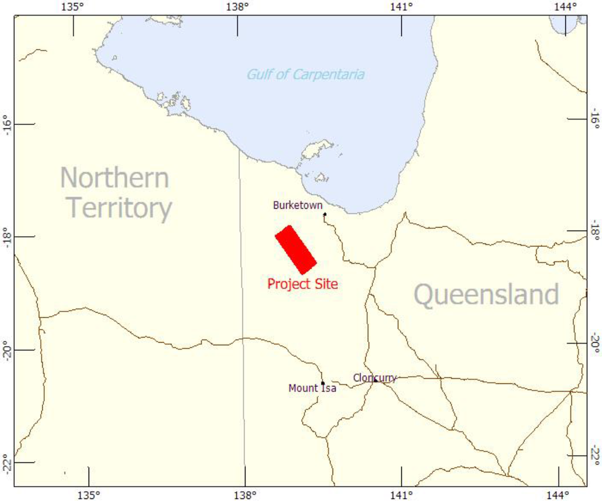
2016 Lawn Hill VTEMTMPlus Survey locality diagram as supplied by Geotech Airborne Pty Ltd
Geoscience Australia contracted Geotech Airborne Pty Ltd to acquire VTEMTMPlus AEM data over part of Lawn Hill area in Queensland from 22 November 2016 to 4 December 2016. The data were also processed by Geotech Airborne Ltd using its FullWaveForm® processing techniques.
The survey area consists of 1658 line km of time-domain AEM geophysical data acquired in traverse lines with a spacing of 2000 m, flown in a northwest - southeast direction; no tie lines were flown.
The original data supplied by Geotech Airborne Pty Ltd has been modified to contain the final data fields of principal interest, enabling a manageable data file size. These data are available from Geoscience Australia's website free of charge. The comprehensive dataset is available from Geoscience Australia by emailing mineralgeophysics@ga.gov.au.
The data release package includes:
- Point-located electromagnetic dB/dt and derived B-field data with associated position, altimeter, orientation, magnetic, and derived ground elevation data. These data are in ASCII column format with associated README and ASEG-GDF2 header files. The dataset consists of separate download files for the:
- Survey Lines
- Repeat lines
- Waveform files for every flight containing the 192 kHz sampling of the transmitter current and receiver waveforms.
- Point-located conductivity estimates derived using the EM Flow® conductivity depth imaging (CDI) algorithm with associated position, altimeter, orientation, magnetic gradiometer, and derived ground elevation data. Data include the conductivity estimate for each 5 m interval and selected depth slices.
- Gridded data, at 500 m cell size in, for the conductivity depth slices derived from the EM Flow® CDI data, magnetics and elevation data in ER Mapper® binary raster grid format with associated header files.
- Graphical multiplots, in PDF format, for each flight line showing EM Flow® CDI sections and profiles of Z-component dB/dt data, magnetics, powerline monitor, height and orientation data.
- Contractor supplied Operations Report.
- ESRI shapefiles and KML files of flight lines.
- Metadata and License files.
Survey specifications of the 2016 Lawn Hilll VTEMTMPlus Survey as supplied from the Geotech Airborne Pty Ltd.
| Survey Block | Line Spacing (m) | Area (km2) | Planned Line-km | Actual Line-km | Flight direction | Line numbers |
|---|---|---|---|---|---|---|
| Lawn Hill | Traverse:2000 | 3215 | 1646 | 1658 | N 145° E / N 325° E | L5000-L5170 |
| TOTAL | 3215 | 1646 | 1658 | |||
East Isa, VTEMTMPlus AEM survey, Queensland
The East Isa VTEMTMPlus airborne electromagnetic (AEM) survey was funded under the Queensland Government's Future Resources (Mount Isa Geophysics) Initiative and managed by Geoscience Australia on behalf of the Geological Survey of Queensland. The project aims to attract explorers into 'greenfield' terranes and contribute to the discovery of the next generation of major mineral and energy deposits under shallow sedimentary cover.
The East Isa VTEMTMPlus AEM survey aimed to capture a new baseline geoscientific dataset by providing further information on the geological context and setting of the area for mineral systems. This dataset assists in defining the distribution and thickness of cover sequences that obscure the basement geology and provide insight into the variation and characteristics of these overlaying sequences. The survey data provides valuable information to assist in understanding the structure and geology of the Proterozoic basement and may also aid in the definition of the groundwater resource potential of the region.
The East Isa survey area consists of 15,697 line-kilometres of time-domain airborne electromagnetic (AEM) geophysical data acquired in the East Isa region of Queensland. The traverse lines were spaced at 2km and 2.5km flown in an east-west direction with three tie lines flown in a north-south direction. The data were collected from June to November 2016 by Geotech Airborne Pty Ltd.
The digital data available includes electromagnetic and magnetic data, conductivity imaging products and mulitplots for all flight traverses; as well as ancillary data including the transmitted EM waveform, the contractor supplied logistics report and images of the Digital Elevation Model (DEM), the Total Magnetic Intensity (TMI) and depth slices of the electrical conductivity transforms. The original data supplied by Geotech Airborne Pty Ltd has been modified to contain the final data fields of principal interest, enabling a more manageable data file size from that originally supplied by Geotech Airborne Pty Ltd. The comprehensive dataset is available from Geoscience Australia by emailing mineralgeophysics@ga.gov.au. The modified data release package is available from Geoscience Australia's website free of charge.
The Data release package includes:
- Point-located "final" electromagnetic dB/dt and derived B-field data with associated position, altimeter, orientation, magnetic gradiometer, and derived ground elevation data.
- The waveform file containing the 192 kHz sampling for the transmitter current.
- Point-located conductivity estimates derived using the EM Flow® conductivity depth imaging (CDI) algorithm with associated position, altimeter, orientation, magnetic gradiometer, and derived ground elevation data. Data include the conductivity estimate for each 5m interval and selected depth slices. Gridded data, at 500m cell size, for the Digital Elevation Model (DEM), the Total Magnetic Intensity (TMI) as well as for the conductivity depth slices derived from the EM Flow® CDI data.
- Graphical multi-plots for each flight line containing; (1) pitch and roll of the transmitter-receiver, (2) transmitter-receiver height, (3) power line monitor, (4) magnetics TMI and first vertical derivative, (5) dBz/dt profiles, (6) CDI in logarithmic colour scale, and (7) CDI in linear colour scale.
- Contractor supplied Operations and Processing Report.
- ESRI shape and MapInfo files of the flight lines.
Southern Thomson Orogen VTEMTMPlus AEM survey
The Southern Thomson Orogen VTEMTMPlus AEM Survey was conducted by Geoscience Australia as part of a collaborative project with its partners the Geological Survey of New South Wales and the Geological Survey of Queensland. The Survey contributes to the Australian Academy of Science's UNCOVER Initiative and Geoscience Australia's response to this as part of the National Mineral Exploration Strategy.
Southern Thomson Orogen VTEMTMPlus AEM survey
Geoscience Australia contracted Geotech Airborne Ltd to acquire VTEMTMPlus AEM data over part of the Southern Thomson Orogen in Queensland and New South Wales in April and May 2014. The data were also processed by Geotech Airborne Ltd using its FullWaveForm® processing techniques.
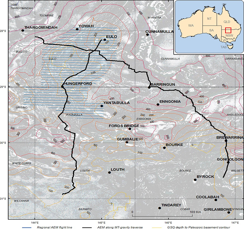
The survey is designed to assess the under-cover geology and prospectivity of the Southern Thomson Orogen around Hungerford and Eulo and straddles the New South Wales-Queensland border. The survey comprises two parts:
- A regular regional survey on 5000 m spaced East-West lines totalling 3352 line km and covering an area of 16 261 km2.
- Two regional traverses adjacent various roads totalling 915 line km.
The Southern Thomson Orogen is a priority area for mineral systems research. Much of the area lies underneath cover of sedimentary basins and is a poorly-understood element of Australia's geology. The Orogen contains Cambro-Ordovician rocks that have potential for Iron Oxide Copper-Gold (IOCG) resources, porphyry copper-gold and Volcanic-Hosted Massive Sulphide (VHMS) deposits. Survey data will add to knowledge of cover thickness and character and will inform future geological mapping in the region.
The Southern Thomson Orogen VTEMTMPlus AEM Survey data release includes the final contractor supplied (Phase 1) datasets AEM survey. The data is available from Geoscience Australia's website free of charge.
The data release package includes:
- Point-located electromagnetic dB/dt and derived B-field data with associated position, altimeter, orientation, magnetic gradiometer, and derived ground elevation data. These data are in ASCII column format with associated README and ASEG-GDF2 header files. The dataset consists of a separate download file for the:
- Main survey block Part 1 (flight lines 1000-1171)
- Main survey block Part 2 (flight lines 1180-1360)
- Traverse lines (flight lines 3000-3006 and 4000-4007)
- Repeat lines
- High altitude lines.
- Waveform files for every flight containing the 192 kHz sampling of the transmitter current and receiver waveforms.
- Point-located conductivity estimates derived using the EM Flow® conductivity depth imaging (CDI) algorithm with associated position, altimeter, orientation, magnetic gradiometer, and derived ground elevation data. Data include the conductivity estimate for each 5m interval and selected depth slices. These data are in ASCII column format with associated README and ASEG-GDF2 header files. All regular survey, traverses and repeat lines are included in a single download file.
- Gridded data, at 1km cell size in, for the conductivity depth slices derived from the EM Flow® CDI data, magnetics and elevation data in ER Mapper® binary raster grid format with associated header files.
- Graphical multiplots, in PDF format, for each flight line showing EM Flow® CDI sections and profiles of Z-component dB/dt data, magnetics, powerline monitor, height and orientation data.
- Operations Report.
- ESRI shapefiles and KML files of flight lines.
- Metadata and License files.
Other product
Capricorn 2013 AEM TEMPEST® survey
The Capricorn 2013 AEM TEMPEST® survey, conducted as part of the Western Australia Exploration Incentive Scheme and managed by Geoscience Australia on behalf of the Geological Survey of Western Australia (GSWA), is a $2.5 million contribution to the Distal Footprints of Giant Ore Systems: UNCOVER Australia project. The Capricorn 2013 AEM TEMPEST® survey is the largest AEM survey by area flown in Australia to date at 146 300 km2 (this is larger than the country of Greece).
Capricorn 2013 AEM TEMPEST Survey flight lines
The Capricorn 2013 AEM survey is Stage 1 of the WA Reconnaissance Airborne Electromagnetic Survey (WARAEM) 2013-20 National Geoscience Agreement project, designed to provide broad-acre, wide line-spacing, airborne electromagnetic (AEM) data over the approximately 70% of the area of Western Australia that is underlain by Precambrian rocks that occur at or within about 300 m of the surface.
The Capricorn Orogen is a geologically complex area, the surface expression of which has a surface extent of approximately 240 000 km2 (approximately 9% of the area of the State). It is prospective for potentially large discoveries of gold, copper, and other base metals.
The Capricorn 2013 AEM TEMPEST data release includes the final contractor supplied (Phase 1) datasets from the TEMPEST® time domain AEM survey as well as a set of GSWA-produced imagery made from the data.
The data release package includes:
- Point-located, computed B-field EM time-series channel data in ASEG-GDF2 (ASCII) format (also TMI and terrain data)
- Point-located computed conductivity and terrain data in ASCII format
- Data multiplots (EM X- and Z-component time series, CDI sections, TMI, altimeter and monitor channels) in PDF format
- CDI stacked sections in PDF format
- Gridded data: EM time constant (X- and Z-components); selected conductivity-depth slices (in ER Mapper format, 1 km cell size)
- Geo-referenced images of gridded EM data in JP2 format
- Geo-referenced images of gridded TMI, Ternary Radiometrics, Bouger Gravity and DEM data in JP2 format
- Flight path map in ESRI shapefile format
- Survey operations report in PDF format
- Metadata and License files
2006-2011 Onshore Energy Security Program
Under Geoscience Australia's Onshore Energy Security Program (OESP), Airborne Electromagnetic (AEM) data was acquired in areas considered prospective for unconformity-related and palaeochannel-hosted uranium deposits. The program was aimed at reducing exploration risk and promoting exploration activity.
The surveys were designed to reveal new information about regions by acquiring the AEM data at line spacings of between one to six kilometres over relatively large areas. The improved understanding of the regional geology resulting from the surveys is of considerable benefit to mining and exploration companies, many of which were co-contributors to the cost of acquisition.
As well as enhancing the search for uranium and other energy sources, the survey results are directly relevant in exploration for a variety of commodities and other resources, including groundwater. The three priority projects chosen for the OESP AEM data acquisition, decided through mineral systems analysis and discussions with the Western Australia, South Australian and Northern Territory Geological Surveys are:
- Paterson Province (Western Australia)
- Pine Creek (Northern Territory)
- Frome Embayment (South Australia)
Project 1 - Paterson Province, Western Australia
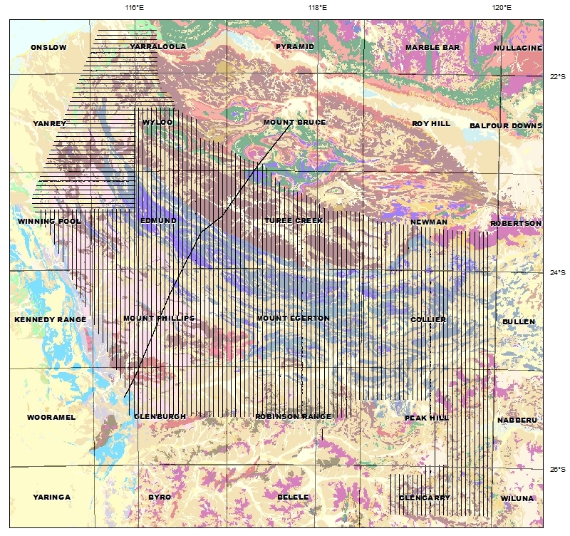
The Paterson project area is centred on the Kintyre uranium deposit and provides AEM data coverage over those areas where Paleoproterozoic Era Rudall Complex and Neoproterozoic Era sediments of the Yeneena Basin either outcrop or are expected to lie beneath less than 500 metres of cover. The area also includes the Telfer gold deposit, the Nifty copper deposit, the Woodie Woodie manganese deposit and others.
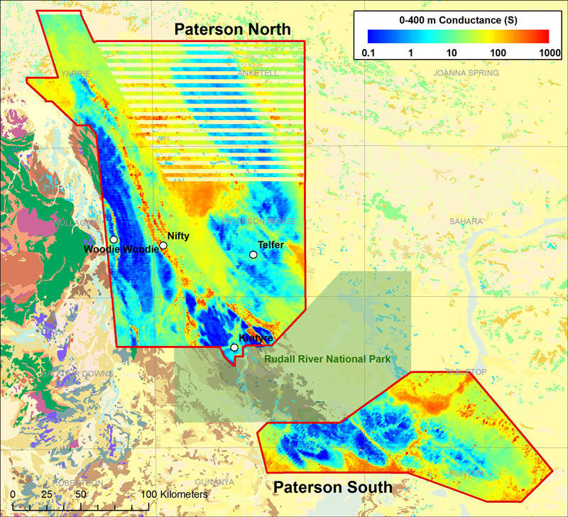
Paterson project, WA
Objectives
- To map unconformities and paleochannels which may be prospective hosts for uranium mineralisation
- To support geological mapping of lithologies and structures in the subsurface
- To improve depth to basement estimates
- To map alteration, mineralisation or host horizons for other commodities including gold, copper and manganese.
Other products
In addition to the AEM data and inversion products linked in the OESP table below, several additional products are available for the Paterson area. These include:
- A drill hole database with explanatory notes for the Paterson TEMPEST AEM survey area. This contains digital data, including geological logs, for more than 4300 public domain historical drill holes
- The Paterson 3D VRML model of the Cottesloe Syncline region in the northwest Paterson Orogen created using 3D GeoModeller. 3D GeoModeller is an emerging technology which constructs 3D volumetric models based on a range of geological information
- A Geoscience Australia interpretation record summarising the AEM data, processing, inversions, interpretation and implications for exploration for uranium and other commodities.
- A logistics report and down-hole conductivity log data for the Paterson AEM Survey area. This report contains down-hole conductivity log data acquired by Geoscience Australia on 14 drill holes within the Paterson survey area.
Project 2 - Pine Creek, Northern Territory
The goal of the Pine Creek AEM survey is to characterise the electromagnetic response of Paleoproterozoic rocks, particularly graphitic units adjacent to Archean granite domes, and map these units in regions of extensive cover, such as the Woolner Granite, and Daly River Basin areas. The project will also attempt to map key sub-surface unconformities and structures which may have units in regions of extensive cover, such as the Woolner Granite, and Daly River Basin areas. The project will also attempt to map key sub-surface unconformities and structures which may have influenced mineralising fluids.
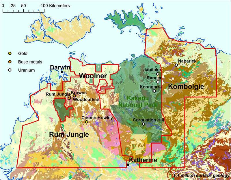
Pine Creek project, NT
Objectives
- To map unconformity and palaeochannel uranium host rocks
- To map the thickness of Kombolgie Subgroup rocks (depth to prospective interface)
- To map graphitic basement conductors
- To map the thickness of regolith cover.
Progress update: November 2011
- Contractor supplied data has been released online
- Integrated geological and geophysical interpretation will be completed late 2011
- Interpretation record released November 2011.
Other products
In addition to the AEM data and inversion products linked in the OESP table below, several additional products are available for the Pine Creek area. These include:
- A Geoscience Australia interpretation record summarising the AEM data, processing, inversions, interpretation and implications for exploration for uranium and other commodities
- A logistics report and down-hole conductivity log data for the Pine Creek AEM Survey area. This report contains down-hole conductivity log data acquired by Geoscience Australia on 24 drill holes within the Pine Creek survey area
- Pine Creek AEM Survey NT Workshop - overview
- Pine Creek Airborne Electromagnetic Data and Procedures for AEM data
- Geological interpretation of the regional Pine Creek airborne electromagnetic survey
- Major Mineral Systems in the PCO: Implications of AEM Data for Uranium Mineral Systems
Project 3 - Frome Embayment-Murray Basin, South Australia
The Frome Embayment-Murray Basin project will provide regional AEM data over a 95 000 square kilometre area between the Flinders Ranges and the State border in South Australia. Extensive Mesozoic to Cenozoic cover blankets the highly prospective area, which hosts major palaeochannel-type uranium deposits at Beverley, Four Mile, Honeymoon and Goulds Dam.
Objectives
- To map palaeochannels which may host uranium deposits
- To map Beverley Sands/Alpha Mudstone
- To map thick channels of the Eyre Formation
- To map faults and fault blocks
- To map depth to cratonic basement, especially over the Benagerie ridge southeast of Lake Frome
- To map alteration or mineralisation involving other commodities including gold, copper, lead and zinc
- To map Murray Basin strand lines.
Progress update: November 2010
- Survey flown between May 2010 and October 2010
- Phase 1 (contractor-supplied) data released March 2011.
Other products
In addition to the AEM data and inversion products linked in the OESP table below, several additional products are available for the Frome Embayment-Murray Basin area. These include:
- Frome airborne electromagnetic survey interpreted palaeovalley GIS package
- A Geoscience Australia interpretation record summarising the AEM data, processing, inversions, interpretation and implications for exploration for uranium and other commodities.
- A logistics report and down-hole conductivity log data for the Frome AEM Survey area. This report contains down-hole conductivity log data acquired by Geoscience Australia on 5 drill holes within the Frome survey area.
- The Frome Airborne Electromagnetic Survey.
- Interpretations from the Frome airborne electromagnetic survey.
Available data
AEM data collected from the surveys and models resulting from them can be downloaded using the links in the table below.
Table of AEM surveys released from 2006 and links to downloadable data
The Geoscience Australia data releases include the contractor supplied data and EM Flow conductivity depth image (CDI) sections for only the lines funded by Geoscience Australia. The complete final data releases make available both the contractor supplied data and Layered Earth Inversions (LEI) sections, grids and interpretive products for all Geoscience Australia and infill company flight lines.
Contractor supplied data includes:
- AEM ASCII data
- AEM Gridded data
- AEM multiplots with EM Flow CDI sections
- Logistics report.
Geoscience Australia inversion products include:
- AEM ASCII LEI models
- AEM ASCII elevation slices
- AEM multiplots with LEI sections
- Grids and georeferenced images of cross sections, total conductance, elevation slices and depth slices
- AEM Go Map showing depth of investigation
- Report.