National Geochemical Survey of Australia Project
Page last updated:16 March 2023
Project description
The National Geochemical Survey of Australia (NGSA) project was established under Geoscience Australia's Onshore Energy Security Program announced in August 2006 and is part of the program's five year plan.
The primary aim of the NGSA is to provide pre-competitive data and knowledge to support exploration for energy resources in Australia. In particular, it will improve the existing knowledge of the concentrations and distributions of energy-related elements such as uranium (U) and thorium (Th) at the national scale.
The project is underpinned by a series of pilot geochemical surveys carried out by Geoscience Australia and the Cooperative Research Centre for Landscape Environments and Mineral Exploration (CRCLEME) to test robust and cost-effective protocols for sample collection, preparation and analysis. Examples of these are the Riverina and the Thomson pilot geochemical surveys.
The current national geochemical survey is being conducted in collaboration with the State and the Northern Territory Geological Surveys.
Project technical notes
Rationale
The NGSA was initiated because of the realisation that there was no complete geochemical coverage available for Australia and because such a data layer is fundamental to successful exploration for energy-related and other commodities.
The objectives of the NGSA project are to:
- collect transported regolith samples at the outlet of large catchments covering more than 90 per cent of Australia using an ultra low sampling density approach
- prepare and analyse the samples to extract the maximum amount of geochemical information (more than 60 elements) using internally consistent, state-of-the-art techniques
- populate the national geochemical database with the resulting new data
- compile an atlas of geochemical maps for use by the exploration industry to identify areas of interest in terms of energy-related resources and other mineral commodities. These areas can then be the focus of targeted exploration efforts.
Strategy
A sampling method has been adapted to Australian landscapes and climate conditions. It has been field-tested in the Riverina, Gawler and Thomson pilot projects. The cost of a national survey is kept reasonably low by applying an ultra low sampling density approach (1 site/1000 square kilometres to 1 site/10 000 square kilometres).
The strategy adopted for the NGSA is:
- Sampling media: Catchment outlet sediments (similar to floodplain sediments in most cases), sampled at two depths (0-10 centimetres below the surface as well as between around 60 and 80 centimetres depth).
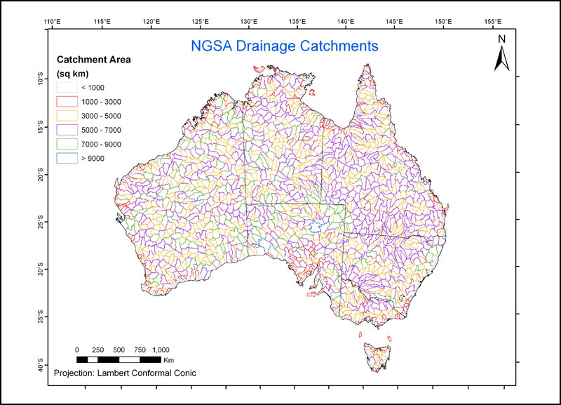
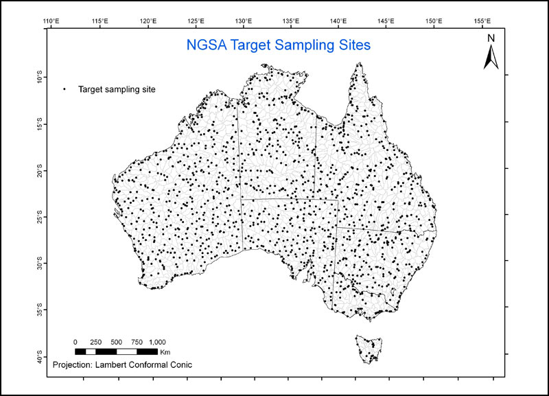
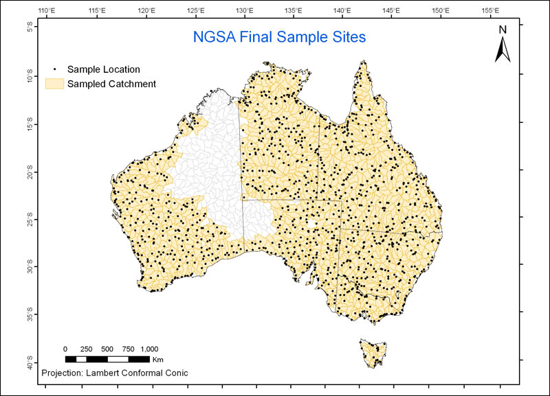
- Sampling sites: 1390 catchments covering 91 per cent (or about seven million square kilometres) of Australia across all States and Territories were targeted for sampling (Figure 3). Most catchments were sampled near their outlet, while those exhibiting internal or poorly defined drainage were sampled at, or as close as possible to, their lowest point. Catchments smaller than 1000 square kilometres (mostly coastal) and small islands were not included in the survey. The resulting distribution of catchment outlet sites targeted for sampling is shown in Figure 4 and translates to an average sampling density of around 1 site/5500 square kilometres.
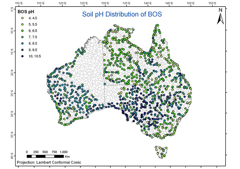
- Sample collection: A report titled National Geochemical Survey of Australia: Field Manual was compiled and all sampling equipment and consumables were centrally purchased. Sample collection was carried out by the State and the Northern Territory Geological Surveys after exhaustive training by the NGSA team. At each locality a detailed site description, field pH (Figure 5) and dry and moist soil Munsell® colours were recorded and several photographs were taken. All field-recorded information has been compiled into a report titled National Geochemical Survey of Australia: Field Data. All information was recorded digitally to facilitate subsequent uploading into databases.
- Sample preparation: Samples were dried, riffle split and sieved to less than two millimetre and less than75 micrometre fractions. The less than two millimetre fraction was mechanically ground for some analyses, while the finer fraction was not. A split of each bulk sample was archived for future investigations. More details can be found in the National Geochemical Survey of Australia: Sample Preparation Manual.
- Sample analysis: Sample analysis was completed in 2010 for more than 60 elements using mainly XRF and collision cell ICP-MS at Geoscience Australia. The ICP-MS analyses were carried out on a total digest (HF+HNO3) of fragments of the XRF beads. Other parameters routinely recorded at Geoscience Australia included pH 1:5 (soil:water slurry), EC 1:5 and laser particle size distribution. Selected elements for which analysis is not available at Geoscience Australia (gold (Au), fluorine (F), selenium (Se), and platinum group elements) were analysed externally. Other digests/analyses (for example after aqua regia digestion, MMI® extraction) have been added to the analytical protocol. Individuals or organisations interested in undertaking additional analyses on NGSA samples should contact Geoscience Australia.
- Quality assessment/quality control: Sample numbers were randomised to minimise regional bias, help separate false from true anomalies and obtain meaningful estimates of the variance of duplicates. Field duplicates, analytical duplicates, in-house standards and certified reference materials were introduced at regular intervals in the analytical streams.
- Data analysis: The production of national-scale geochemical maps will be carried out prior to their release as a web-based atlas on this website. Reports providing preliminary interpretations and graphical and statistical analysis also will be released on the website.
- Timeline: Following planning in the first half of 2007, fieldwork, including initial training, began in mid 2007 and ran until late 2009. Figure 6 shows the final distribution of sampled catchments. Of the 1390 targeted catchments, 1186 could be accessed in time, yielding approximately 80 per cent coverage of the nation. Including six large catchments which were subject to additional sampling higher up in the landscape and 123 sampled in duplicate for quality control, the NGSA project has collected samples at 1315 sites across the continent. Sample preparation started in late 2007 and concluded at the end of 2009. Sample analysis began in late 2008 and concluded in mid 2010. Data analysis and reporting are taking place during 2010-11 prior to the project's conclusion on 30 June 2011.
Project outputs
- National Geochemical Atlas of Australia: Web or Report
- Publications on various aspects of the project, including preliminary energy and mineral exploration implications of the new geochemical dataset
- Reports on the geochemistry of all States and the Northern Territory by their respective Geological Surveys, as appropriate
- Preliminary soil pH map of Australia
- Release of the NGSA geochemical dataset
- Release of the NGSA catchment polygons GIS dataset
- Release of the NGSA particle size dataset.
Project outcomes
- Increased knowledge of the concentrations and distributions of geochemical elements in the near surface environment at the national scale
- Use of NGSA data to select specific areas for further exploration activity for and investment in energy-related resources in Australia.
Related information
- The following CRCLEME open file reports are available from the CRCLEME Open File Report INDEX:
- Riverina region geochemical survey, southern New South Wales and northern Victoria
- Gawler region geochemical survey, South Australia (Volumes 1 and 2)
- Thomson region geochemical survey, northwestern New South Wales