North Australia Project Mineral Promotion
Page last updated:8 April 2016
This project concluded on 30 June 2006.
Project description
The North Australia Project (NAP) was a collaborative project within the National Geoscience Agreement (NGA). The project involved investigations of the geodynamics, geochronology and mineral systems of the southern North Australian Craton.
The NGA is an umbrella for a series of bilateral work programs between Geoscience Australia and the State and Territory Geological surveys. The Chief Government Geologists Committee provides a strategic overview for the NGA and deals with common issues relating to standards, broad delivery to industry of the results of Geoscience Australia's efforts and its contributions and report to the Australian and New Zealand Minerals and Energy Council (ANZMEC) on progress with the NGA and issues arising from it. All modules within the North Australia Project involved close collaboration with the Northern Territory Geological Survey (NTGS) and the Geological Survey of Western Australia (GSWA) by provision of Geoscience Australia's specialist expertise.
Project outcome
Increased exploration activity in, and the promotion of, the Northern Territory and Western Australia for mineral exploration.
Project outputs
- Reports, prepared in collaboration with the NTGS and GSWA, that documented the age, structural timing, fluid characteristics, structural and geochemical controls and ore genesis of lode Au mineral system(s) in the Tanami region.
- A 3D architectural model of the Tanami region showing the geometry of major faults, stratigraphic units and granites, using forward modelling and inversion of potential field data.
- A deep seismic reflection survey, in collaboration with GSWA, NTGS, Newmont Australia and Tanami Gold that identified the geometry of major structures, granites and the depth of the Moho in the Tanami region.
- A gravity data set for the Tennant Creek area, in collaboration with NTGS.
- Reports, in collaboration with NTGS, that documented the event chronology of mafic magmatism in the Arunta Province, and the geochemistry, petrology and nickel-copper-platinum group element mineral potential of the associated orthomagmatic mineral systems.
- Reports, in collaboration with NTGS, that summarised the results of geochronological investigations for the Tanami, Arunta, Tennant Creek and Pine Creek regions.
- Geophysical interpretation, in collaboration with NTGS, of aeromagnetic data for the Lake MacKay, Mount Doreen , Mount Rennie and Mount Liebig 1:250 000 sheets.
- Geophysical interpretation, in collaboration with GSWA, of aeromagnetic data for parts of the Billiluna, Gordon Downs and Lucas 1:250 000 sheets.
- Interpretation, in collaboration with NTGS, of the reprocessed seismic line across the south and central Arunta Province to determine the regional geological architecture and its implications on potential for diamond, lode Au, and sediment-hosted zinc-lead-silver mineral systems.
- Reports, in collaboration with NTGS, that documented the origin, age, and geological controls on base metal deposits in the Strangways Ranges, eastern Arunta.
- Reports, in collaboration with NTGS, that documented the origin, age and geological controls on base metal, molybdenum-tungsten and gold deposits in the Molyhil-Jervois area, eastern Arunta.
- A final public conference, Evolution and metallogenesis of the North Australian Craton that provided an overview of the geodynamics and mineral systems of the southern part of the North Australian Craton.
Science Results
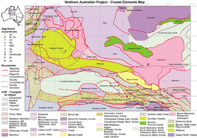
Figure 1. Australian Crustal Elements Map
When the North Australia Project was initiated in 2000, the North Australian Craton (NAC) was one of the least understood megaelements recognised in the Australian Crustal Elements Map (Figure 1), interpreted at that time to be bounded in the south by a continental-scale magnetic anomaly (Figure 2). This megaelement included mostly Paleoproterozoic basement blocks and extended east from the Kimberley Block to North Queensland, incorporating the Pine Creek Orogen, the Tanami region, and the Arnhem, Tennant and Murphy Inliers in the Northern Territory. Although the Arunta region lies largely to the south of the magnetic anomaly, it contains rock successions (e.g. Lander Rock beds) of broadly similar age and lithology to those in the Tanami Region. The younger history of the combined North Australian Craton-Arunta region (or the North Australian Craton) is dominated by the deposition of Proterozoic superbasin sequences, including the MacArthur and Victoria-Birrindudu Basins, which have been the focus of studies under the North Australian Basins Resource Evaluation (NABRE) project, and the Neoproterozoic to Paleozoic Georgina and Amadeus Basins.
Results of regional mapping conducted by NTGS, and of jointly acquired geochronological and seismic data, have significantly changed the original understanding, extending the southern margin of the North Australian Craton well to the south, and characterising two new geological provinces, the Warumpi and Aileron Provinces, within the Arunta region. Currently, the North Australia Craton is interpreted to extend to the southern margin of the Warumpi Province, and the magnetic feature upon which the original southern boundary was assigned is now considered to be Neoproterozoic to Paleozoic in age. Development of this feature is considered to be linked to the evolution of the Irindina Province, a high-grade metasedimentary succession that correlates with the low-grade Georgina and Amadeus Basins to the north and south, respectively.
Based upon these new data, and data acquired as part of the Predictive Mineral Discovery Collaborative Research Centre's (pmd*CRC) Mt Isa Project and the North Queensland component of the Regional Geodynamics Project, under Geoscience Australia's Onshore Energy Security Program (OESP), Figure 3 shows the current interpretation of the internal make-up of the North Australian Craton. Features used to define the internal elements include crustal boundaries, as identified from deep seismic surveys and extended at surface using geophysical data sets, geochronological patterns and variations in neodymium and lead isotopes. These interpretations are currently being tested by the Georgina-Arunta component of the Regional Geodynamics Project and Onshore Petroleum Project of the OESP.
The work also has questioned the evidence for Archean to early Proterozoic (so-called Barramundi) foundation to much of the southern NAC. The data suggest that most of the Tanami and all of the Arunta was deposited after ~1850 Ma, and was derived in large part from Barramundi-aged (1880-1850 Ma) provenance. This requires reassessment of tectonic models advocated for the formation of the NAC.

Figure 2. Total Magnetic Intensity Image
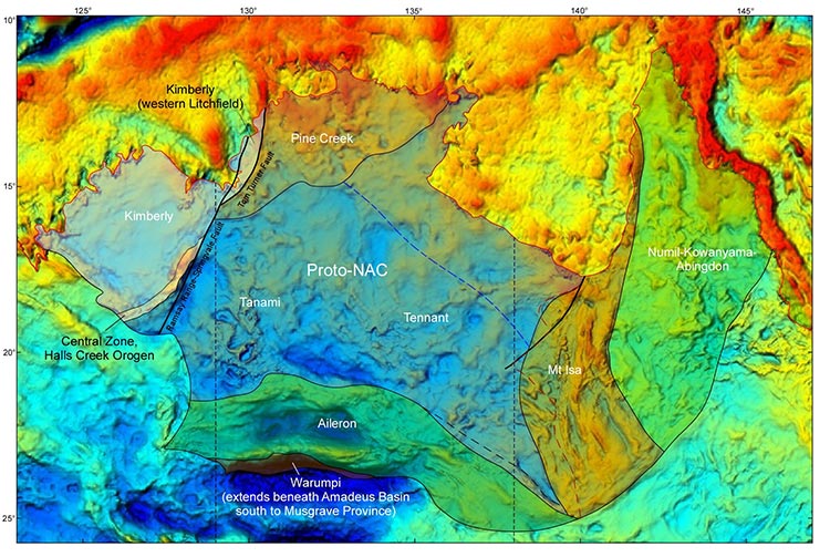
Figure 3. Tectonic elements of the North Australian Craton superimposed on a Bouger gravity anomaly map
Mineral systems
The North Australian Craton is one of Australia's major mineral provinces, containing the world's largest zinc-lead-silver province, and major uranium, copper and gold provinces. Of these the Tanami gold province, as well as other smaller polymetallic mineral provinces, were examined during the North Australian Craton Project. The North Australian zinc province and the northwest Queensland copper province have been the subject of the pmd*CRC projects and of the North Queensland component of the Regional Geodynamics Project. Uranium mineralisation in the Pine Creek Province, Ngalia Basin and Amadeus Basin is the subject of the current Uranium Systems Project under the OESP.
Tanami gold province
The Tanami gold province has emerged as one of Australia's major Proterozoic gold provinces. Since the early 1980s, total resources and production in excess of 300 tonnes of gold have been defined from the Tanami, The Granites and Dead Bullock Soak districts, with the Callie deposit, which contains total resources and production in excess of 180 tonnes, one the world's premier Proterozoic gold deposits. To understand controls on mineralisation, the project undertook research at a number of different scales, in collaboration with NTGS and GSWA, including:
- the Tanami deep seismic reflection survey
- geochronology of the Tanami province
- structural contols on mineralisation at the regional and local scale
- chemical controls on mineralisation
- the mineralogy of the ores
- the age of the ores.
Results of these studies can be found in a series of papers which constitute a special issue of Mineralium Deposita on 'The Tanami Gold Province' (2007, v. 42, pp. 1-204) as well as in individual papers by Goleby et al. (2008, Tectonophysics, v. 472, p. 169-182), and Lambeck et al. (2008, Precambrian Research, v. 166, pp. 185-203; 2010, Mineralium Deposita, v. 45, pp. 497-515 ). Important results include:
- the southern margin of the Tanami Province was recognised as a major crustal boundary, juxtaposing this province with the Aileron Province to the south
- links were identified using seismic data between major structural elements (crustal-penetrating shear zones and anticlines) and mineralisation
- geochronological constraints were established on the age of sedimentation and magmatism
- a temporal link between gold mineralisation (1810-1800 Ma) and granite intrusion (1815-1795 Ma) was established
- the composition and evolution of gold mineralising fluids were established
- a chemical stratigraphy was established to identify host successions, including the most gold-prospective Dead Bullock Formation
- mineral system models illustrating the interplay between structural, stratigraphic and geochemical elements and gold mineralisation were developed.
In addition to these results, geological and geochronological data suggest a similar timing of small gold prospects in the Aileron Province to the Tanami gold event.
Tennant Creek gold-copper province
The Tennant Creek goldfield is one of the most significant, and most unusual, mineralised province in the Northern Territory, having produced over 156 tonnes of gold as well as significant copper (0.345Mt), selenium (220t) and bismuth (14kt). Recent years have seen a re-emergence of exploration, with significant discoveries, including zinc-lead-silver discoveries, in the Tennant Creek goldfields and in the analogous Rover field to the southwest. To assist in the understanding of this region, the project undertook geochronological studies to establish the relationship between gold mineralisation and other geological events in the Tennant Creek area. Important results include:
- the age for Tennant Creek mineralisation was established ~1845 Ma, which is consistent with geological relationships (Fraser et al., 2008, Precambrian Research, v. 164, pp. 50-65)
- a preliminary age of ~1842 Ma was determined for the host succession in the Rover field, an age within error to the age of mineralisation
- a temporal link between Tennant Creek mineralisation and magmatism of the Tennant Creek Supersuite was established.
Orthomagmatic nickel-copper and platinum-group-element systems
The Arunta region contains a number of mafic and mafic-ultramafic intrusions of varying size and age. Although no significant discoveries have been made to date, some of these bodies are inferred to have potential for orthomagmatic nickel-copper and platinum-group-element deposits. The project undertook an extensive regional geochemical and geochronological sampling program of these intrusions with the intent of providing constraints on their age and mineral potential. Full results are presented in Hoatson and Stewart (2001, Field investigations of Proterozoic mafic-ultramafic intrusions in the Arunta Province, central Australia, Geoscience Australia Record 2001/39), Hoatson et al. (2005, Precambrian Research, v. 142, pp. 93-133), Clauoé-Long and Hoatson (2005, Precambrian Research, v. 142, pp. 134-158), Meixner and Hoatson (2003, Geophysical interpretation of Proterozoic mafic-ultramafic intrusions in the Arunta Region, central Australia, Geoscience Australia Record 2003/029), and Miezitis et al. (2006, Mineral potential modelling of Proterozoic mafic-ultramafic intrusions in the Arunta Region, Central Australia, Geoscience Australia Record 2006/014). Important results include:
- new uranium-lead zircon geochronology data highlight episodic emplacement of the mafic-ultramafic systems, including five major tholeiitic mafic events at ~1810 Ma, ~1780 Ma, ~1690 Ma, ~1635 Ma, and during the early Paleozoic, and an event with alkaline-ultramafic affinities at ~1135 Ma
- geochemical data define two groups of intrusions and indicate geographical differences in mineral prospectivity:
- a sulphur-rich group from the western and central Arunta region that has potential for basal nickel-copper-cobalt-sulphide associations,
- a relatively sulphur-poor, slightly more primitive group from the eastern Arunta region that has greater potential for stratabound PGE-sulphide associations
- 2D forwarding modelling indicate that six intrusions (Andrew Young Hills, Anburla Anorthosite, Enbra Granulite, Mount Chapple Metamorphics, Mount Hay Granulite and Kanandra Granulite) have subsurface extents that far exceed their known outcrop, with a depth of burial beneath alluvial cover of less than 120m.
Systems associated with convergence along the southern margin of the North Australian Craton
The Aileron Province contains a number of small zinc-lead-copper and gold-copper prospects, including those in the Jervois district, and individual prospects at Oonagalabi, Edwards Creek, Johnnies Reward and elsewhere. To assist in understanding the spatial and temporal distribution and genesis of these prospects, the project, in conjunction with the NTGS, undertook detailed mapping and alteration, isotopic and geochronological studies of these and other prospects. Complete results of the activities are presented by Hussey et al. (2005, Geology and origin of some Cu-Pb-Zn (-Au-Ag) deposits in the Strangways Metamorphic Complex, Arunta Region, Northern Territory, NTGS Report 17). Important results include:
- three periods of mineralisation were recognised: 1810-1800 Ma volcanic-associated massive sulfide (VAMS: e.g. Edwards Creek), 1790-1780 Ma iron-oxide copper gold (IOCG: e.g. Johnnie's Reward and Jervois) and ~1760 VAMS zinc-lead (e.g. Oonagalabi)
- the earlier VAMS deposits are relatively widespread in the Strangways Metamorphic Complex and correspond in age with lode gold deposits in the Tanami gold province
- the IOCG deposits overlap in age with Yambah-aged granites
- all of these deposits are interpreted to have formed as a consequence of north directed subduction below the southern margin of the North Australian Craton, an interpretation consistent with the presence of 1790-1780 Ma tonalite-trondjhemite-granodiorite suite granites (the CAT suite of Zhao and McCulloch, 1995, Precambrian Research, v. 71, pp. 265-299) in the region.
Other mineral systems
The southern part of the North Australian Craton also contains a number of other mineral deposits, of variable timing and origin. These include:
- tungsten and molybdenum deposits in both the Davenport area (e.g., Hatches Creek West district) and in the eastern part of the Aileron Province (e.g., Molyhil W-Mo deposit)
- deposits related to alkaline magmatism (e.g., Nolans, Mud Tank).
Although the project did not target these deposits for extensive work, limited work produced the following results:
- geochronological data indicate that the Molyhil skarn and tungsten deposits in the Hatches Creek districts have an age of ~1720 Ma
- preliminary geochronological data from the Nolans deposit suggests an age of ~1245 Ma, compatible with the age of alkaline dykes within the Pine Creek region in the northern part of the North Australian Craton.
Although no mines or adanced prospects have been identified, uranium prospects are scattered through the Tanami, Tennant Creek and Arunta regions. However, the most significant prospects are located in the Ngalia Basin and in the northern part of the Amadeus Basin. These prospects are sandstone-hosted, and unconformily-related prospects are known in the Tanami region in the Killi Killi Hills area. These prospects are the subject of geochronological work by the Uranium Systems Project of the OESP.
Exploration update
A summary of recent exploration activities and results can be accessed through the NTGS Exploration News Database (updated quarterly).