Deepwater Otway Basin
Page last updated:12 December 2025
Pre-competitive work in the offshore Otway Basin has concluded and the following publications are available for download. Additional activities undertaken in this region, from work in the Carbon Capture, Utilisation and Storage Project, under Resourcing Australia's Prosperity may provide additional useful information.
Improved understanding of the Deepwater Otway Basin
The Otway Basin
The Otway Basin is a passive margin basin located in southeastern Australia Figure 1. The basin is predominantly offshore but also occurs onshore in South Australia and Victoria. The basin hosts Late Jurassic–Cenozoic sediments. It has gas production onshore Victoria and South Australia, as well as offshore Victoria in the Shipwreck Trough, and no oil discoveries have been made. Water depths range from shelfal to over 6000 m in the offshore. Offshore producing gas fields currently include Black Watch, Casino-Henry-Netherby, Enterprise, Geographe, Halladale, Speculant and Thylacine. The Minerva gas field has been decommissioned.
Other discoveries are known and are under retention lease, including Artisan and La Bella. The most recent discovery is that of Essington 1, made in November 2025.
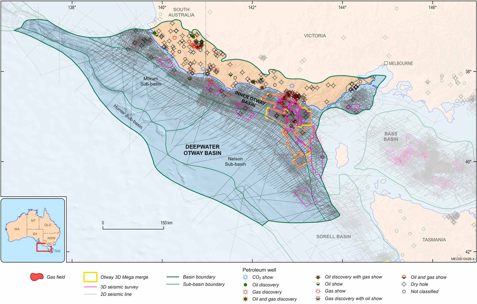
Figure 1. Otway Basin showing seismic coverage, tectonic elements, petroleum wells and fields for the offshore.
Deepwater Otway Basin Study
Prior to 2020 data coverage of the deep-water parts of the basin was limited, with seismic coverage at approximately 100km line spacing. The 2020 Otway Basin 2D seismic program (Schenk et al., 2021) improved resolution over most of the area to 10 km line spacing (Figure 1). Utilising the new seismic, gravity, magnetics and bathymetry data, reprocessed data and integrating more recent and legacy well data, a comprehensive re-evaluation of the offshore Otway was performed by Geoscience Australia from 2020 to 2024, and this has greatly improved understanding of the Deepwater Otway Basin.
Data improvement
From the 2020 Otway Basin seismic program undertaken by SLB 7011.675 km of deep (12s) broadband 2D seismic data was acquired and processed to PreSDM (Schlumberger, 2021b). Also acquired during the 2020 seismic survey was gravity and magnetic line data, and multibeam data. Additional seismic data includes the Otway Basin Regional 2D Reprocessing 2020 PreSTM & PreSDM—selected lines from surveys AGSO MS137 and DS01 Sorell processed to PreSDM, while selected lines from surveys Chevron EPP22, OP80, Trocopa, Copacabana, OTOX06 Christine, OS02 and OEP04 processed to PreSTM (Schlumberger, 2021a).
Additionally, an open file post-stack merge of 8092 km2 of 3D seismic data was made available in 2024 which covers the Shipwreck Trough part of the basin (Gunning et al., 2024).
Interpretation and mapping
In the Otway Basin unconformity-bound seismic supersequences are associated with multi-stage rifting and thermal subsidence basin phases related to the separation of Gondwana and Antarctica from the Late Jurassic to the Eocene (Krassay et al., 2004). (Totterdell et al., 2014) recognised that the sparse coverage and poor imaging in legacy seismic data was a limiting factor in the geological understanding of the Deepwater Otway Basin.
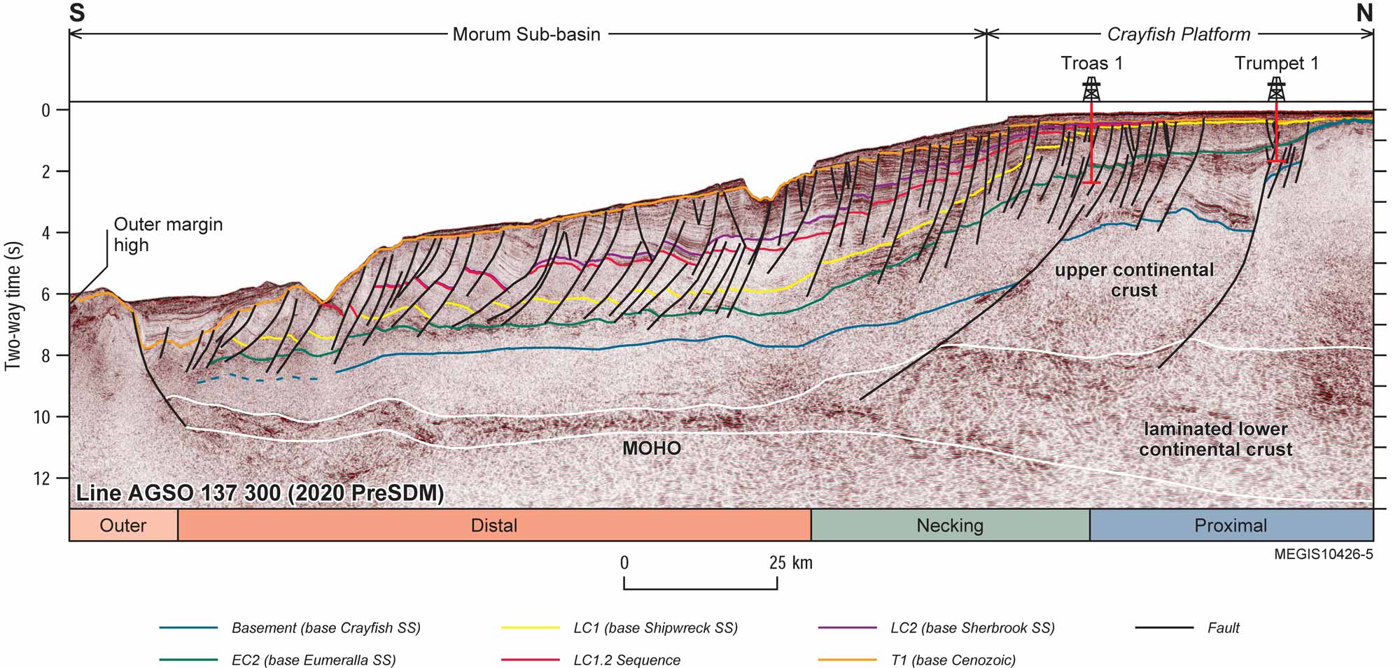
Figure 2. Seismic stratigraphy and structure interpretation of the Cretaceous and deep crustal reflectors on representative seismic profiles across the offshore Otway Basin. Dip line from the Crayfish Platform and Morum Sub-basin.
The Deepwater Otway Basin Study extended the Late Cretaceous supersequence and fault mapping across the offshore Otway Basin (Nicholson et al., 2022), an example shown in Figure 2. This mapping built on initial mapping on the new 2D seismic grid by Schenk et al. 2021, and on the shelf, in the southeast of the basin, by Romine et al. (2020).
Seismic mapping of Cretaceous supersequence boundaries, with emphasis on the Upper Cretaceous Shipwreck and Sherbrook supersequences, is refined across the 2020 Otway Basin 2D seismic program grid and extended over an additional ~40,000 line-km of legacy 2D seismic data. The supersequences are tied to eighteen wells with reference to updated well biozonations (MGPalaeo, 2020). In addition, new gravity and magnetic line data during the 2020 Otway Basin 2D seismic program enables the generation of more accurate gravity and magnetic maps for the offshore Otway Basin, which have been used in refinement of the major structural elements (PoudjomDjomani and Gunning, 2022). The interpretation and mapping extended across the entirety of the offshore part of the basin, as illustrated in Figure 3.
A better understanding of the sedimentary processes and the formation of the Morum and Nelson sub-basins was achieved, particularly discrimination of the Sherbrook and Shipwreck supersequences, and the changes in deposition across the Cretaceous (Nicholson et al., 2024). This interpretation was supported by potential field modelling, to resolve Basement. Results include definition of a new basin boundary and major structural elements (Figure 3).
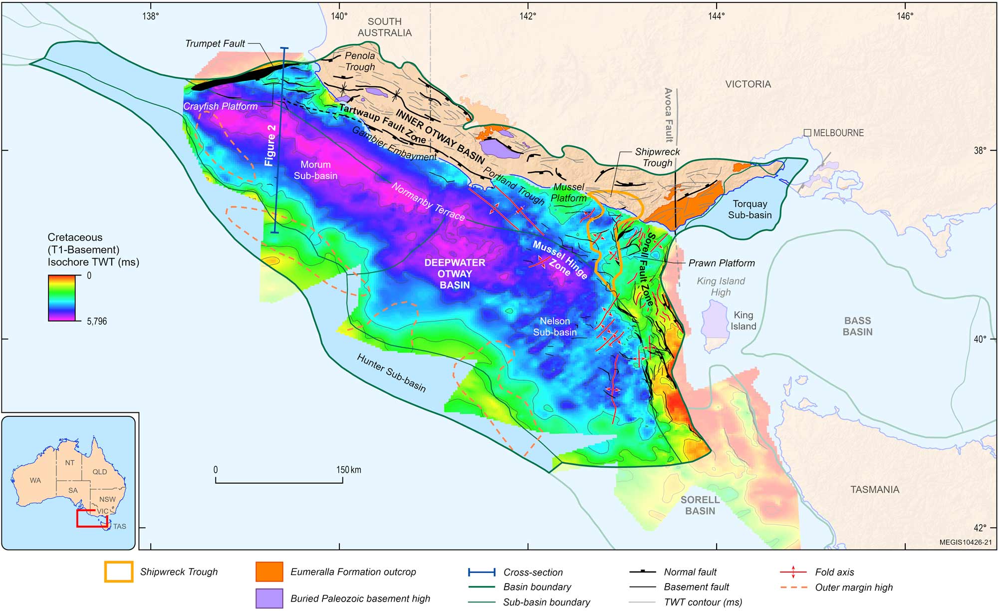
Figure 3. Structural elements map of the Otway Basin showing updated basin boundaries, basement-involved faults, fold axes and outer margin high outlines overlying the Cretaceous (latest Jurassic-base Cenozoic) depocentre isochore (T1-Basement) map.
Integrated Basin Assessment
Revisiting the legacy well data across the basin included petrophysical analysis (Nguyen et al., 2024; Nguyen et al., 2022), core logging (Cubitt et al., 2024), updates to biostratigraphy (Hanneford & Mantle, 2020), chemostratigraphy (Gunning et al., 2024) and organic geochemical analysis (Edwards et al., 2024). All of these are available as data releases.
These results were also integrated with the mapping to inform the interpretation of a series of gross depositional environment (GDE) maps for the Sherbrook Group by Abbott et al (2023; 2024) and Cubitt et al (2023). Based on interpretation of core logs, wireline logs, lithology, and seismic facies analysis (Figure 4). The maps show the distribution of Fluvial Plain (sandstone dominated), Delta-coastal Plain (sandstone and mudstone), and Shelf (mudstone dominated) regional gross depositional environments, and therefore, provide an indication of source, reservoir and seal rock distribution. For each interval, the maps show a large deltaic complex that prograded into the basin from the northwest. The shelf mudstone intervals together contribute to the regional seal for hydrocarbon accumulations in the Shipwreck Trough.
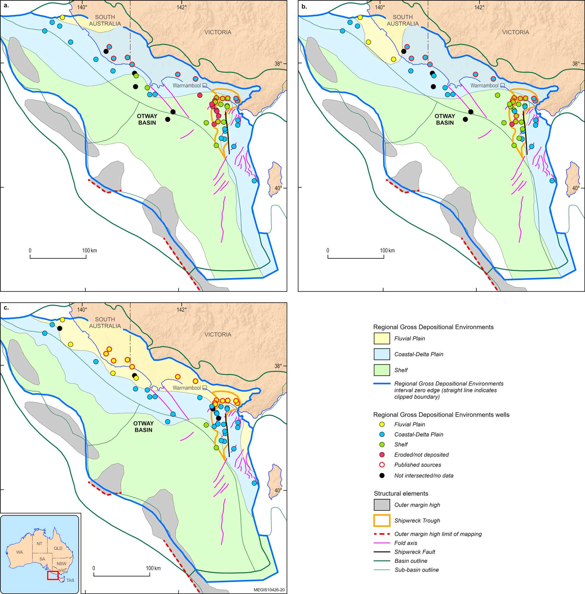
Figure 4. Sherbrook Group regional gross depositional environment maps for the (a) Shipwreck Supersequence (LC1.1 sequence) (b) Shipwreck Supersequence (LC1.2 sequence) and (c) Sherbrook Supersequence (LC2 sequence). See Abbott et al, 2024 for sequence stratigraphic framework.
Utilising the updated regional potential field data (PoudjomDjomani & Gunning, 2022a) and modelling results (PoudjomDjomani & Gunning, 2022b) and integration with seismic interpretation, a better understanding of Basement has been obtained (PoudjomDjomani et al., 2024), albeit impacted by the effects of shallow volcanics.
Petroleum Systems Modelling
While understanding of the basin has improved significantly, a lack of well control in the deep-water area, along with challenges in tying inboard well information due to structural complexity, remain. The proven petroleum systems onshore and in the Shipwreck Trough include: Austral 1, broadly correlating to the Crayfish Supersequence (Late Jurassic – Barremian); and Austral 2, broadly correlating to the Eumeralla Supersequence (Aptian-Albian). Additionally, a postulated Turonian-Santonian, Shipwreck Supersequence equivalent, source rock (Austral 3) has been suggested (O'Brien et al., 2009). Petroleum Systems Modelling, incorporating the Austral 3, suggests prospectivity in the Morum Sub-basin that is yet to be tested, with only one well in the area, Troas 1 ST1, demonstrating gas. Schenk et al. (2021) provide an overview of hydrocarbon generation and entrapment potential for the deep-water province using several basin transect models from the new 2020 Otway Basin 2D seismic program grid, mapped sequences and extrapolated petroleum well maturation parameters from the inboard shelfal areas. This was further updated (Figure 5) incorporating the updated supersequence mapping and gross depositional environment interpretation in Schenk et al. (2023).
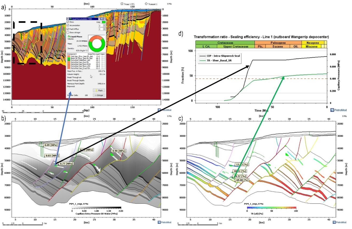
Figure 5. Predicted accumulation in the outboard Morum Sub-basin: a) modelled section b) predicted sealing efficiency c) transformation ratio of source rocks d) timing relationship of transformation ratio and sealing efficiency (Schenk et al., 2023).
A range of products including data and publications are available as a result of the Deepwater Otway Basin Study.
Data products
Datasets
- Abbott, S., Bernardel, G., & Nicholson, C. (2022). Offshore Otway Basin: Surface Grids, Isochore Grids, and Fault Maps (digital dataset and metadata statement). (Version Updated 2024) Geoscience Australia. https://dx.doi.org/10.26186/146398
- Cubitt, C., Nguyen, D., & Stoate, A. (2024). Offshore Otway Basin core logs (digital dataset and metadata statement). ([Core logs]. Geoscience Australia. https://dx.doi.org/10.26186/149190
- Edwards, D., Darrah, T., & Lary, B. (2024). Noble gas isotopes of natural gases from the shipwreck trough, offshore Otway Basin, Victoria, Australia (digital dataset and metadata statement). (Geoscience Australia. https://dx.doi.org/10.26186/148929
- Nguyen, D., Cubitt, C., Edwards, D., Abbott, S., & Bernardel, G. (2024). The central and southeast offshore Otway well folio (digital dataset and metadata statement). (Geoscience Australia. https://dx.doi.org/10.26186/149458
- Nguyen, D., Edwards, D., Gunning, M., & Bernardel, G. (2022). The Northwest Offshore Otway Basin Well Folio (digital dataset and metadata statement). (Geoscience Australia. https://dx.doi.org/10.26186/146429
- Schlumberger. (2021a). 2020 Otway Basin regional PreSTM and PreSDM 2D reprocessing. (ENO0603870; [SEGY]. https://public.neats.nopta.gov.au/nopims/reprocessing or ausgeodata@ga.gov.au.
- Schlumberger. (2021b). Otway Basin MC 2D MSS 2020. (ENO0603786; [SEGY]. https://public.neats.nopta.gov.au/nopims/reprocessing or ausgeodata@ga.gov.au.
Reports and news articles
- Cubitt, C., Nguyen, D., & Stoate, A. (2024). Offshore Otway Basin core logs (digital dataset and metadata statement). ([Core logs]. Geoscience Australia. https://doi.org/10.26186/149190
- Edwards, D., Darrah, T., & Lary, B. (2024). Noble gas isotopes of natural gases from the shipwreck trough, offshore Otway Basin, Victoria, Australia (digital dataset and metadata statement). (Geoscience Australia. https://doi.org/10.26186/148929
- Gunning, M.-E., Nguyen, D., Riley, D., Tansell, C., & Bufarale, G. (2024). Chemostratigraphy of the Sherbrook Supersequence – 13 wells from the offshore Otway Basin. Australian Energy Producers Journal, 64(2), S382-S387. https://doi.org/10.1071/EP23204
- Hanneford, C., & Mantle, D. (2020). Biostratigraphic and sequence stratigraphic summary data for selected offshore Otway Basin wells.
- Nguyen, D., Cubitt, C., Edwards, D., Abbott, S., & Bernardel, G. (2024). The central and southeast offshore Otway well folio (digital dataset and metadata statement). (Geoscience Australia. https://doi.org/10.26186/149458
- Nguyen, D., Edwards, D., Gunning, M., & Bernardel, G. (2022). The Northwest Offshore Otway Basin Well Folio (digital dataset and metadata statement). (Geoscience Australia. https://doi.org/10.26186/146429
- O'Brien, G. W., Boreham, C. J., Thomas, H., & Tingate, P. R. (2009). Understanding the critical success factors determining prospectivity, Otway Basin, Victoria. The APPEA Journal, 49, 129-170.
- PoudjomDjomani, Y., & Gunning, M. (2022a). Gravity and magnetic enhancement grids and images for the Otway Basin seismic program 2020 (digital dataset and metadata statement). (Geoscience Australia. https://doi.org/10.26186/146433
- PoudjomDjomani, Y., & Gunning, M. (2022b). Potential field interpretation and modelling in the deep-water Otway Basin (extended abstract). The APPEA Journal, 62, S487-S491. https://doi.org/10.1071/AJ21209
- PoudjomDjomani, Y., Gunning, M., Bernardel, G., & Nguyen, D. (2024). How deep is the basement beneath the Otway Basin? Insight from semi-automated magnetic depth estimates. 1st ASEG DISCOVER Symposium, Hobart.
- Schenk, O., Grosjean, E., Edwards, D., Borehoam, C., West, T., Karvelas, A., & Kornpihl, D. (2023). Petroleum system modelling of the deep-water Otway Basin. 4th Australasian Exploration Geoscience Convention, Brisbane Convention and Exhibition Centre.
- Schenk, O., Karvelas, A., West, T., & Kornpihl, D. (2021). Otway basin regional study report. G. Australia. https://dnxxuwuw8tglo.cloudfront.net/Surveys/D00019710.zip
- Schlumberger. (2021a). 2020 Otway Basin regional PreSTM and PreSDM 2D reprocessing. (ENO0603870; [SEGY]. https://public.neats.nopta.gov.au/nopims/reprocessing or ausgeodata@ga.gov.au.
- Schlumberger. (2021b). Otway Basin MC 2D MSS 2020. (ENO0603786; [SEGY]. https://public.neats.nopta.gov.au/nopims/reprocessing or ausgeodata@ga.gov.au.
- Totterdell, J. M., Hall, L., Hashimoto, T., Owen, K., & Bradshaw, M. T. (2014). Petroleum geology inventory of Australia’s offshore frontier basins (Record 2014/09, Issue.
Journals and Conference proceedings
Conference proceedings
- Schenk, O., Grosjean, E., Edwards, D., Borehoam, C., West, T., Karvelas, A., & Kornpihl, D. (2023). Petroleum system modelling of the deep-water Otway Basin. 4th Australasian Exploration Geoscience Convention, Brisbane Convention and Exhibition Centre.
References
- Krassay A.A., Cathro D.L. and Ryan D.J., 2004. A regional tectonostratigraphic framework for the Otway Basin. In ‘Eastern Australasian Basins Symposium II’. (Eds Boult P.J., Johns D.R., and Lang S.C.) pp. 97–116. Petroleum Exploration Society of Australia, Special Publication.
- MGPalaeo (2020), Palynological summary sheets. Available at https://www.mgpalaeo.com.au/otway-basin/, viewed on Feb 16, 2022.
- Totterdell J.M., Hall L., Hashimoto T., Owen K. and Bradshaw M.T., 2014. Petroleum geology inventory of Australia’s offshore frontier basins. Record 2014/09. Geoscience Australia, Canberra.
Related Information
- Australian Government Offshore Petroleum Exploration Acreage Release: https://www.industry.gov.au/policies-and-initiatives/investing-in-offshore-petroleum-exploration
- Regional Geology of the Otway Basin | Geoscience Australia