Australia’s landscapes and coastlines refreshed from space with DEA’s 2025 annual product update
Page last updated:30 April 2026
Australia’s land, water and coastlines are constantly changing, reshaped by floods and droughts, vegetation growth and loss, storms, tides, and long‑term shifts in climate. Each year, Digital Earth Australia (DEA) captures these changes from space through its annual product update, delivering a consistent, national picture of how the continent is evolving.
DEA has now released its 2025 annual product update, refreshing a suite of terrestrial and coastal datasets used by scientists, governments, industry and communities to analyse, monitor and understand environmental change across Australia.
Why annual updates matter
DEA products are widely used across research, policy and operational settings across the country. Regular, predictable updates ensure these datasets remain current, trusted and fit for purpose, giving users confidence that the information they rely on reflects the most recent year of observed change across Australia’s land, water and coastal environments.
A consistent national view of change
The 2025 update includes refreshed terrestrial data to the following DEA products, including DEA Land Cover, DEA Fractional Cover, DEA GeoMAD, DEA Tasseled Cap Percentiles , DEA Water Observations (annual and seasonal summaries), and DEA Mangroves Canopy Cover, alongside coastal products including DEA Coastlines, DEA Intertidal and DEA Tidal Composites.
Together, these datasets provide a consistent, Australia‑wide view of how vegetation, surface water and coastal environments have changed over the past year and, in some cases, over decades. As part of this release, DEA Water Observations multi‑year summaries have been extended through to 2025, supporting improved analysis of long‑term surface water trends.
Capturing dramatic coastal change
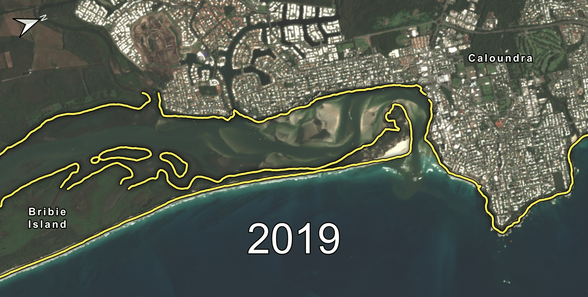
Annual DEA Coastlines showing the two breaches of Bribie Island (2022 and 2025) on Queensland’s Sunshine Coast.
One of the most striking examples in the 2025 update comes from Bribie Island on Queensland’s Sunshine Coast. DEA Coastlines records the 2022 breach of northern Bribie Island during Tropical Cyclone Seth, which split the island in two. Since then, Coastlines highlights the widening of the new opening and the gradual closure of the original Caloundra Bar entrance.
The latest update also captures a second breach in early 2025, providing a spatial record of rapid, natural coastal change.
Landcover captures record breaking floods across Central Australia’s Channel Country
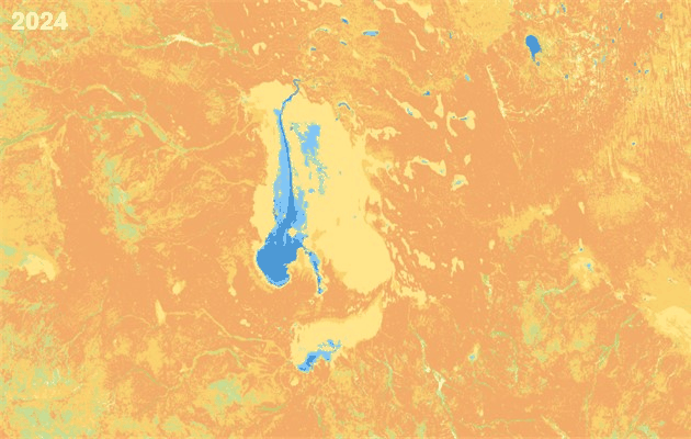
DEA Land Cover classification (level 4) for 2025 showing Lake Eyre filling up with water following record breaking rainfall in the 2024-25 wet season, across Central Australia’s Channel Country.
Inland, record rainfall during the 2024–25 wet season transformed Queensland’s Channel Country. DEA Land Cover demonstrates how floodwaters spread through normally dry river channels and floodplains.
This large‑scale flooding event demonstrates how Australia’s dry and semi‑dry landscapes respond to extreme climate variability and how satellite data can reveal these changes consistently at continental scale.
Explore the 2025 data
The updated 2025 datasets can be explored visually in DEA Maps, with technical documentation and change notes available through the DEA Knowledge Hub. Dedicated DEA Tech Alerts provide guidance on what has changed and how updates may affect existing workflows.
Share and subscribe
Make sure you stay up to date with Digital Earth Australia by subscribing to the newsletter. New to the newsletter? Check out our past releases. Did you find this useful? Share this with your network and let them experience the benefits of Digital Earth Australia.