Bathymetry
Page last updated:19 July 2017
Bathymetry is the study and mapping of the sea floor. It involves obtaining measurements of the depth of the ocean and is the equivalent to mapping topography on land.
Bathymetric data is used for a range of purposes including:
- charting and ship navigation
- fisheries management
- environmental management, including establishing baseline data to support environmental monitoring
- determination of maritime boundaries
- alternative energy assessments (i.e. to support offshore wind and wave energy assessments)
- research into coastal processes and ocean currents, for example tsunami modelling
- assessment of environmental considerations for marine geology resource management including the identification of geohazards, such as underwater landslides
Bathymetry Data
Generally very little is known about the sea floor. Existing maps of the sea floor are often low resolution, having been derived from satellites, and only provide a general indication of water depth.
Bathymetric data is collected in multiple ways:
- Satellite data can be used to produce maps showing general features over a large area at low resolution. Satellite altimetry measures the height of the ocean surface. If there are hills/mountains on the sea floor, the gravitational pull around that area will be greater and hence the sea surface will bulge. This measurement can be used to show where the seafloor is higher, and this can be used to produce maps showing general features over a large area at low resolution.
- Single beam echosounders produce a single line of depth points directly under the equipment. These measurements are usually made while a vessel is moving to identify general sea floor patterns and/or schools of fish.
- Equipment that captures swathes of data by acquiring multiple depth points in each area, such as multibeam echosounders (or swath echosounders) and airborne laser measurements (LADS). These datasets are very high resolution, with data down to better than one metre accuracy.


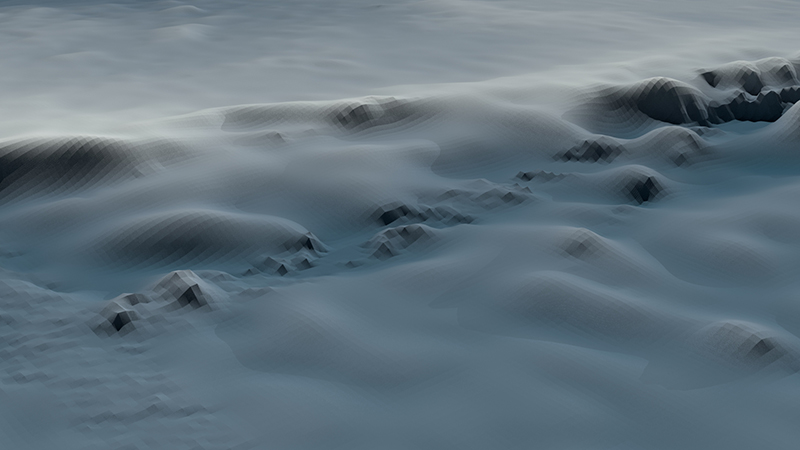
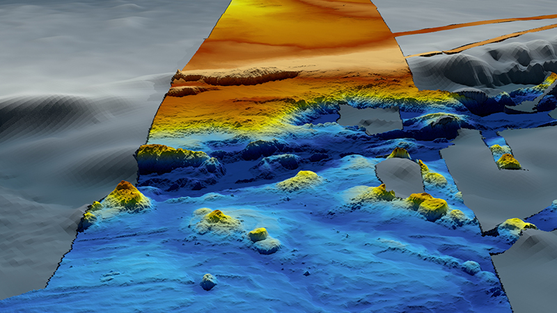
Figure 1. Before and after images of the sea floor showing a) Image of the sea floor mapped using satellite data, and b) image of the sea floor in the same location as figure 1a, however this image shows a strip of high resolution data (in colour) where multibeam data has been acquired.
Multibeam Bathymetry Surveys
Geoscience Australia collects bathymetry data in multiple ways, mostly commonly using multibeam surveys. During a bathymetric survey, a multibeam sonar system is mounted on the hull of a survey vessel. The sonar system sends out multiple soundwaves that bounce off the sea floor and return to the ship. The delay between sending and receiving the signal provides a measurement of ocean depth (Figure 2). These measurements are then used to produce a map charting the sea floor.
Acquiring high resolution multibeam data is time-consuming because the survey vessel moves through the area in overlapping lines to capture the data in a systematic way (Figure 3). Overlapping the lines increases confidence in the data’s accuracy and helps address any gaps in the data caused by factors such as bad weather.
Different frequencies are used to map different water depths. Overall, the higher the frequency, the better the resolution of data produced, because the high frequency soundwaves will reach the seafloor at more of an angle, creating better return signal. However, high frequency waves dissipate faster and as such, in deep water, they may dissipate before reaching the seafloor. As a result, higher frequencies (greater than 100 kHz) are used for shallow water and low frequencies (less than 30 kHz) are used for deeper water.
As the depth of the water increases, the resolution of the data decreases because of two factors:
- A low frequency system is required in deep water so that the soundwaves can reach the sea floor.
- The deeper the water, the greater the area the beam covers. The fan-like shape of the sonar wave spreads out through the water column until it reaches the sea floor (see figure 2). As the water gets deeper, the more the fan spreads out, and the more area is covered by the beam. To increase the resolution of the data collected in deep water, the fan can be narrowed to collect data of a smaller area; this increases the resolution but it is more time-consuming as many more lines of data will need to be acquired.
When processing multibeam bathymetry data, corrections need to be made to allow for factors such as water salinity, sea temperature and ocean depth; as these factors affect how quickly sonar signals travel through the water.
Figure 2. The sonar system mounted on the hull of the vessel sends out soundwaves that bounce off the sea floor and return to the ship.
Bathymetry Products
Geoscience Australia uses datasets acquired internally and by other agencies and companies to produce a range of products to meet Government and scientific needs. These include:
- Maps of individual surveys
- A 50m multibeam dataset of Australia
- The Australian Bathymetry and Topography Grid, (2023). This compilation of different bathymetric datasets merged into a seamless grid has a spatial resolution of 250m. Geoscience Australia also produces a range of other products that use bathymetric data, including geomorphology and seabed hardness.
The Australian Hydrographic Office retains a copy of every bathymetric survey acquired in Australian waters to be used for charting and navigation purposes.
Visualizations of Sea Floor Terrain
Geoscience Australia produces 3D animations and other visualisation products, allowing viewers to ‘fly through’ the sea floor terrain.

