SouthPAN frequently asked questions
Page last updated:28 November 2023
About Global Navigation Satellite Systems (GNSS) and Satellite Based Augmentation Systems (SBAS)
Global Navigation Satellite Systems (GNSS) are constellations of satellites transmitting radio signals used for position, navigation, and timing by land, sea, and airborne users in all weather conditions, anywhere and anytime. There are four GNSS with global coverage; these are the United States' Global Positioning System (GPS), Russia's GLObalnaya NAvigatsionnaya Sputnikovaya Sistema (GLONASS), the European Union's Galileo, and China's BeiDou Navigation Satellite System (BeiDou). There are two satellite systems with regional coverage, Japan's Quasi Zenith Satellite System (QZSS), and the Indian Regional Navigation Satellite System (IRNSS). Using one or more of these GNSS constellations is often referred to as ‘standalone GNSS’. Australia is one of a few countries in the world with high visibility to all six constellations.
Satellite Based Augmentation Systems (SBAS) are a separate satellite system that augments the performance of standalone GNSS. SBAS signals are transmitted from separate satellites, but they are similar to GNSS signals to ensure they can be used with most end-user devices. SBAS can augment one or more GNSS.
Satellite Based Augmentation Systems (SBAS) are an established technology that augments the performance of standalone GNSS such as GPS, GLONASS, Galileo and Beidou. Augmentation improves GNSS performance parameters including accuracy, integrity, and availability. SBAS works by collecting raw positioning data from GNSS Reference Stations (GRS) across the service region, and using this data to compute corrections, which are then transmitted from an uplink station to a satellite in Geostationary Earth Orbit (GEO) and then broadcast to users. For aviation purposes, Safety-of-Life certified SBAS signals also provide position integrity to users, allowing SouthPAN to be used for continuous vertical guidance during runway approach procedures.
For further information about SBAS, see:
Benefits of SouthPAN
An SBAS Test-bed project ran from 2017 to 2019 to assess the feasibility and benefits of an operational SBAS for Australia and New Zealand. The project demonstrated the economic, social, and environmental benefits of improved positioning technologies across industry sectors, with an expected value of $7.6b over 30 years for Australia and New Zealand.
SouthPAN enhances GNSS accuracy for a wide range of applications such as precision agriculture, construction, automation, intelligent transport systems, and location-based services on smartphones, estimated to provide economic, social, and environmental benefits, with an expected value of $7.6b over 30 years for Australia and New Zealand.
SouthPAN is openly available to all GNSS users throughout Australia and New Zealand.
SouthPAN will also provide a certified Safety-of-Life Service for use by aviation, currently planned to commence in 2028. Other Safety-of Life applications for SouthPAN may emerge in the coming years, including in the maritime, road, and rail sectors.
For further information about SBAS, see:
About SouthPAN
SouthPAN early Open Services have been available to users since September 2022 and are constantly being improved. A certified Safety-of-Life Service will be provided for aviation users from 2028.
Three early Open Services are available: L1 SBAS, Dual Frequency Multi-Constellation (DFMC SBAS) and PPP Via SouthPAN (PVS).
SouthPAN early Open Services are available:
- L1 SBAS - provides augmentation of the GPS L1 C/A signal and can be certified for safety-of-life.
- Dual Frequency Multi-Constellation (DFMC SBAS) - provides augmentation of the GPS L1 C/A, GPS L5, Galileo E1, and Galileo E5a signals. DFMC sends corrections for two satellite frequencies (L1+L5) and multiple satellite constellations (GPS + Galileo)
- PPP Via SouthPAN (PVS) - PVS is similar to DFMC SBAS in that it augments GPS L1 C/A, GPS L5, Galileo E1, and Galileo E5a signals but provides additional information that allows End-Users to achieve more accurate position. The PVS Open Service is currently provided on the SouthPAN L5 navigation signal, and will be migrated to the new L5b navigation signal in 2027.
Early Open Service performance attributes such as accuracy and availability will improve as additional infrastructure is established during system deployment. Full Operating Capability (FOC) is scheduled for 2028.
For information on the integrity and accuracy of each of these services, go to Service Definition Document for Signal-in-Space Services [PDF 925.6 KB], Service Definition Document for Data Access Services [PDF 1.4 MB] and SouthPAN early Open Services factsheet [PDF 3.3 MB].
Many GNSS receivers compatible with WAAS, EGNOS and other SBASs can track and process SouthPAN L1 SBAS signals.
New GNSS receivers can also track and process the L5 frequency bands for GPS and Galileo, and a small range of them have added support for Dual Frequency Multi-Constellation (DFMC SBAS) and Precise Point Positioning via SouthPAN (PVS). We are engaging original equipment manufacturers (OEMs) to improve support for SouthPAN Early Open Services in consumer devices.
For a list of verified SouthPAN compatible devices, visit the compatible devices [XLSX 55.0 KB] list or check with your manufacturer about the capability of your receiver.
To receive information about SouthPAN subscribe to the Geoscience Australia Positioning News.
Geoscience Australia and Toitū Te Whenua Land Information New Zealand are responsible for SouthPAN. The operational capability of SouthPAN is delivered by Lockheed Martin Australia, GMV, and Inmarsat Australia.
SouthPAN services are transmitted via geostationary satellite and can be received by any compatible GNSS device used outdoors in areas with a clear sky-view of the satellite, within the service area defined in the Service Definition Document [PDF 925.6 KB]. SouthPAN services delivered via the internet can be accessed worldwide however the relevance of the correction data is limited to the service area.
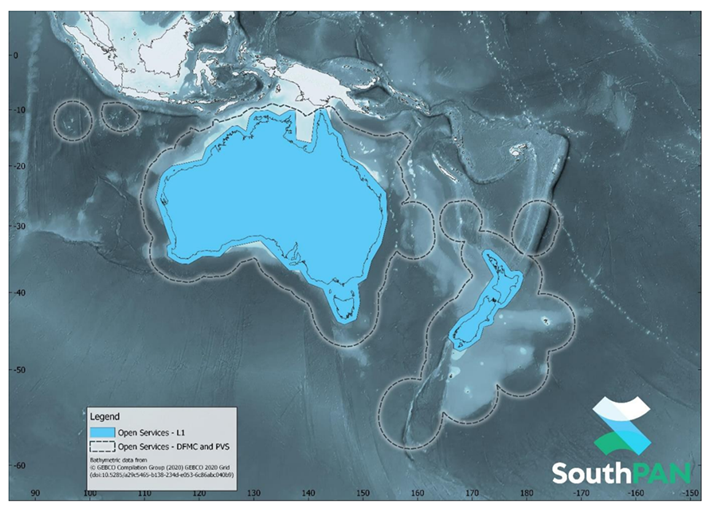
SouthPAN early Open Services coverage. OS-L1 covers mainland Australia and New Zealand. OS-DFMC and OS-PVS cover both countries’ Exclusive Economic Zones.
SouthPAN services are open-access and free to use with any compatible GNSS device. For a list of compatible devices, see compatible devices [XLSX 55.0 KB] list .
The following documents contain additional information about SBAS technology:
- Service Definition Document for Signal-in-Space Services [PDF 925.6 KB]
- Service Definition Document for Data Access Services [PDF 1.4 MB]
- RTCA DO-229F: Minimum Operational Performance Standards for GPS / SBAS Airborne Equipment
- EUROCAE ED-259: Minimum Operational Performance Standards for Galileo / GPS / SBAS Airborne Equipment
Most GNSS devices compatible with WAAS, EGNOS and other SBAS can be used with the SouthPAN L1 SBAS service. Because DFMC SBAS is a new system, a smaller range of receivers can track and process L5.
Some GNSS receivers may need a configuration change or firmware upgrade. Check with your manufacturer to learn more about the capability of your receiver. For a list of GNSS receivers that have been verified as SouthPAN compatible, visit the compatible devices [XLSX 55.0 KB] list.
Some newer GNSS receivers can also track and process the L5 frequency bands for GPS and Galileo, however, currently only a small range of GNSS receivers have added support for DFMC SBAS and PVS at this time.
To check the GNSS capability of your Android smartphone, you can use the GPSTest app.
To review configuration for some common GNSS receivers go to the following FrontierSI page.
For general information on SouthPAN:
For information on accessing SouthPAN on your device, refer to the Service Definition Document [PDF 925.6 KB] for Open Services, the SouthPAN early Open Services Factsheet [PDF 3.3 MB], or contact your equipment manufacturer.
For all other enquiries:
Equipment manufacturers
For general information on SouthPAN:
- ga.gov.au/southpan
- Subscribe to Geoscience Australia Positioning News.
For technical information, go to Service Definition Document [PDF 925.6 KB].
For all other enquiries contact:
To include your SouthPAN compatible device to this list contact clientservices@ga.gov.au or southpan@linz.govt.nz
Technical information
L1 SBAS delivers corrections for one satellite constellation and signal. For example, SouthPAN, WAAS, and EGNOS send corrections for GPS L1. Dual-Frequency Multi-Constellation (DFMC) services offered by “next-generation SBAS” deliver corrections for two satellite frequencies (L1+L5) and multiple satellite constellations (in SouthPAN’s case, for GPS + Galileo). The combination of two frequencies removes the need to correct for atmospheric errors that affect GNSS signals. DFMC is a standard for future SBAS, providing improved integrity and precision and was demonstrated during the SBAS test-bed in Australia and New Zealand.
Precise Point Positioning (PPP) is a high-accuracy positioning technique used in commercial services and open services such as QZSS Centimetre-Level Augmentation Service (CLAS), and Galileo High Accuracy Service (HAS). PPP Via SouthPAN (PVS) is a high-accuracy service that improves position accuracy to ≤0.40m horizontal and ≤0.55m vertical (95% confidence interval). Full position accuracy is achieved after a convergence period better than 80 minutes during PVS early Open Services. The user does not need to remain stationary during the convergence period.
For information on the performance of PVS, go to Service Definition Document [PDF 925.6 KB] and SouthPAN early Open Services factsheet [PDF 3.3 MB].
L1 SBAS is the signal that has been used in compatible GNSS devices since 2003. L1 SBAS were primarily designed as an integrity monitoring system for safety-critical operations in civil aviation, and later adopted for other applications in a wide range of industries.
SouthPAN is a “next-generation SBAS” that also transmits a Dual-Frequency Multi-Constellation (DFMC) service augmenting two frequencies on each of GPS and Galileo. DFMC is a standard for future SBAS, providing improved integrity and position accuracy.
PVS is the Precise Point Positioning (PPP) Via SouthPAN Open Service that provides real-time orbit and clock corrections, and additional signal bias corrections. This technique allows for more precise positioning but requires a ‘convergence period’ for that precision to be achieved.
For information on the performance of each of these services, go to Service Definition Document [PDF 925.6 KB] and SouthPAN early Open Services factsheet [PDF 3.3 MB].
PVS is being transmitted through SouthPAN’s L5 navigation signal. PVS corrections will also be transmitted via Internet. The PVS correction messages are applicable to:
- GPS L1 C/A and L5 signals
- Galileo E1 and E5a signals
In the future, PVS will be transition from SouthPAN’s L5 navigation signal to a new L5b navigation signal. The L5b signal has some advantages over L5, including high bandwidth so more correction data can be transmitted, faster. The transition date is scheduled for 2027.
The PVS early Open Service signal shares the L5 frequency with the DFMC SBAS Open Service signal. SouthPAN PVS signal will transition to a new navigation signal centred on 1,207.14 MHz. The transition date is scheduled for 2027. Geoscience Australia and Toitū Te Whenua Land Information New Zealand will publish more information prior to transition.
The Service Definition Document [PDF 925.6 KB] provides details on the reference frames used by SouthPAN.
The Service Definition Document [PDF 925.6 KB] provides characteristics of SouthPAN early Open Service messages.
PRN 122 is used for the Australia and New Zealand SBAS service.
A ‘PRN code’ is a unique code used by each GNSS satellite so that End-User Equipment can distinguish one satellite from the others. This is important because all satellites providing the L1 positioning service transmit on the same frequency: 1,575.42 MHz. PRN means Psuedo-Random Noise, which is a digital signal processing technique that makes weak signals easier to detect, as well as combining different data on the same frequency.
PVS compatible GNSS receivers are not yet widely available. We are working with original equipment manufacturers (OEMs) to ensure support and availability of PVS compatible receivers for the Australia and New Zealand markets.
There are some receivers specifically built for the SBAS Test-bed project, which can utilise all three SouthPAN early Open Services – see compatible devices [XLSX 55.0 KB] list. It is also possible to use a software-defined radio (SDR) and PPP engine to decode the PVS correction signal, for use with a supported GNSS device.
The Service Definition Document [PDF 925.6 KB] provides details on SouthPAN service performance. The accuracy and convergence times will improve as additional infrastructure is deployed.To receive system information and stay up to date with the SouthPAN events, subscribe to Geoscience Australia Positioning News.