Southern Positioning Augmentation Network (SouthPAN)
Page last updated:6 May 2026
The Southern Positioning Augmentation Network (SouthPAN) is a joint initiative of the Australian and New Zealand Governments that provides Satellite-Based Augmentation System (SBAS) services for Australia and New Zealand. Geoscience Australia as the Australian Government lead agency, is working in collaboration with Toitū Te Whenua Land Information New Zealand on the development, deployment, and operation of SouthPAN, the first SBAS in the Southern Hemisphere.
SouthPAN is a Satellite-Based Augmentation System (SBAS) comprised of reference stations, telecommunications infrastructure, computing centres, signal generators, and satellites that provide improved positioning and navigation services in Australia, New Zealand, and its maritime region.
SouthPAN delivers three early Open Services: L1 SBAS, Dual Frequency Multi-Constellation (DFMC) SBAS, and Precise Point Positioning Via SouthPAN (PVS).
SouthPAN is a “next-generation SBAS”, which means that-in addition to delivering an Open Service augmenting the GPS L1-C/A navigation signal-we also transmit a Dual-Frequency Multi-Constellation (DFMC) Open Service augmenting the GPS L1-C/A and L5 navigation signals, and Galileo E1 and E5a navigation signals. The aviation sector globally are working towards standardising DFMC services as the primary future SBAS, providing improved integrity and precision.
Precise positioning from SouthPAN will offer accuracy at as little as 10 centimetres: a significant improvement on previous accuracy of 5 to 10 metres. SouthPAN provides augmented and corrected satellite navigation signals directly from the satellite rather than through a mobile phone. This allows as little as 10 centimetre level accuracy to be available everywhere, overcoming gaps in mobile, internet and radio communications. For example, this provides improved accuracy in our regional and remote areas, as well as in our maritime zones.
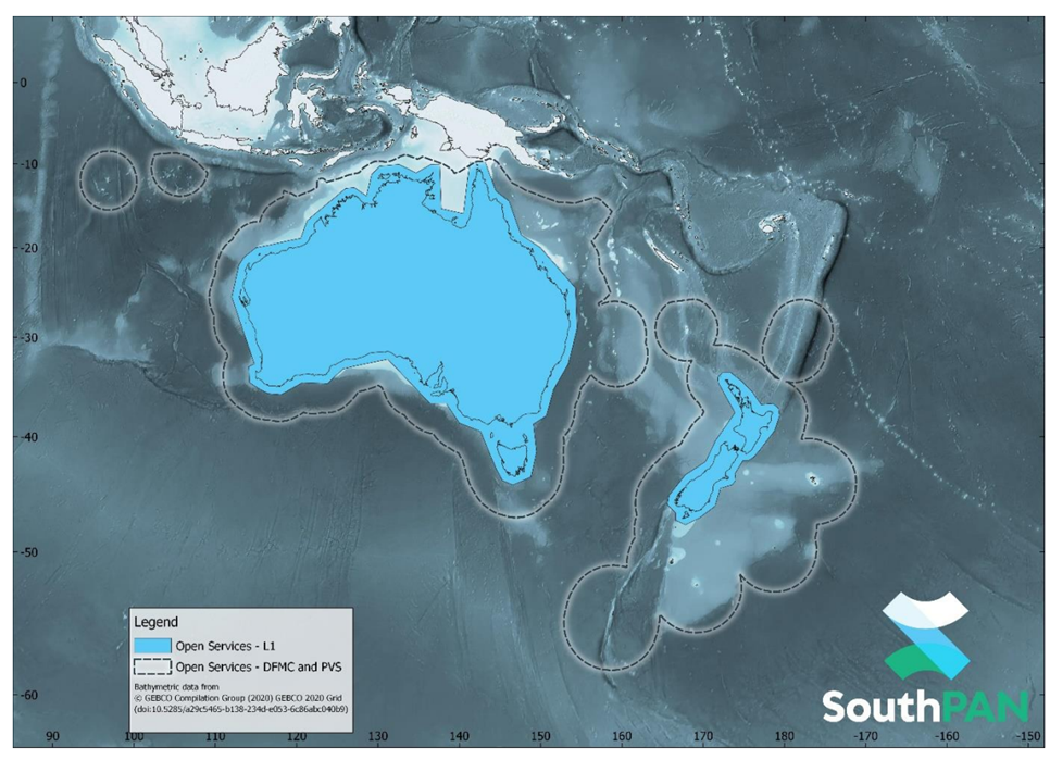
SouthPAN early Open Services coverage. OS-L1 covers mainland Australia and New Zealand. OS-DFMC and OS-PVS cover both countries Exclusive Economic Zones
SouthPAN early Open Services have been live since September 2022, with safety-of-life certified SouthPAN services planned in 2028.
Lockheed Martin Australia is contracted to establish and deliver ongoing SouthPAN services to Australia and New Zealand. The system is designed to meet global performance requirements under Australia and New Zealand’s unique service area and space weather conditions.
As part of this contract, Lockheed Martin Australia will build the ground segment of SouthPAN, including the network of ground reference stations and satellite uplink facilities.
Inmarsat Australia is contracted to broadcast SouthPAN services from one of the new Inmarsat I-8 satellites, commencing from 2027.
In May 2023 we went live on AusTender to procure access to an additional navigation transponder hosted on a satellite in Geostationary Earth Orbit (GEO). The service will be the second satellite navigation service to support SouthPAN, and will be named SouthPAN GEO Payload – 02 (SGP-02). More information about the SGP-02 procurement is available on AusTender.
SouthPAN’s precise positioning technology was tested in the Satellite Based Augmentation System (SBAS) test-bed project, which ran between 2017 and 2019. The test-bed project assessed the economic, social and environmental benefits of improved positioning technology through industry case study projects.
SouthPAN commenced in 2020 under the Australia New Zealand Science, Research and Innovation Cooperation Agreement between Geoscience Australia and Toitū Te Whenua Land Information New Zealand.
Geoscience Australia is currently seeking expressions of interest for SouthPAN ground station site hosts.
You are able to stay up to date with our latest announcements by subscribing to Positioning News.
SouthPAN SBAS Test Bed projects
SouthPAN’s Satellite-Based Augmentation System (SBAS) test-bed project assessed the economic, social and environmental benefits of improved positioning technology through 27 demonstrator user case study projects across ten different industry sectors. This included projects across agriculture, aviation, construction, consumer, resources, road, rail, maritime, mining and utilities.
You can view how the SouthPAN user case study test-bed projects will make an impact to Australian society and industry. Following the test-bed, EY produced an independent economic benefits analysis of the program. This analysis found that accurate and reliable positioning from SouthPAN has an expected value of $7.6 billion over 30 years for Australia and New Zealand, based on the tested applications of the program.
About SouthPAN
The Australian Government has contributed $1.4 billion towards the SouthPAN project over the next 20 years. The purpose of the program is to deliver a national capability that accelerates the adoption and development of location-based technology and applications.
SouthPAN sees Australia and New Zealand join countries such as the United States, Europe, Russia, India and Japan, which have all invested in capabilities that deliver satellite-based corrections via an SBAS. It also supports the aviation, maritime and road transport sectors in meeting requirements for high-integrity positioning-guaranteed performance with sub-metre level accuracy.
For technical information on SouthPAN see the SouthPAN FAQs.
For further information on other SBAS systems, see:
How SouthPAN works
SouthPAN uses a number of distributed ground stations to monitor signals broadcast by Global Navigation Satellite System satellites, and compares each station’s known location with position data from the satellites.
The GNSS signal data and measurement information is sent to correction processing facilities. The facilities aggregate the data from all ground stations, produce error corrections and status information about the GNSS satellites, and format the data in a standardised series of messages. These messages are sent to an uplink station, which transmits data to a satellite in geostationary earth orbit. The data is broadcast to all precise positioning users, who combine SouthPAN’s data with their own observations of GNSS satellites.

SouthPAN will offer as little as 10 centimetre level accuracy across Australia, New Zealand and its maritime zones
SouthPAN briefing
On 16 November 2022, Simon Reynolds, Engineering Manager for the SouthPAN project provided a SouthPAN briefing. You are able to watch the recording of the briefing below. Should you have any questions after viewing the video, you are able to submit your questions to clientservices@ga.gov.au.
Satellite navigation and SouthPAN
How to get access
Many positioning-capable consumer devices already have SouthPAN-ready receivers. We recommend contacting your equipment or device manufacturer to ensure your product is compatible with SouthPAN.
GNSS equipment manufacturers, applications developers, and end-users should use the Service Definition Document for Signal-in-Space Services [PDF 925.6 KB] to make use of SouthPAN's Early Open Services provided via satellite navigation signals.
GNSS equipment manufacturers, applications developers, and end-users should use the Service Definition Document for Data Access Services [PDF 1.4 MB] to make use of SouthPAN's Early Open Services provided via the internet.
Geoscience Australia through FrontierSI also provides technical expertise, and liaison with Original Equipment Manufacturers, universities, industry and government to ensure users can benefit from SouthPAN’s precise positioning.
Additional information can be found in the SouthPAN Open Services factsheet for end-users [PDF 3.3 MB].
SouthPAN delivers three services: L1 SBAS, Dual Frequency Multi-Constellation (DFMC) SBAS, and Precise Point Positioning Via SouthPAN (PVS). FrontierSI, on behalf of Geoscience Australia and Toitū Te Whenua Land Information New Zealand are testing the compatibility and performance of SouthPAN services on a range of GNSS devices used across industry sectors. The SouthPAN-compatible device table shows the current status of this compatibility test program. Devices are organised by manufacturer and model, with results listed as:
- Tested by FrontierSI: device is compatible and has been verified by FrontierSI.
- Manufacturer specifications: device is compatible based on published manufacturer specifications, but not verified.
This table will be updated as new compatible devices are identified. This list is not exhaustive, so we encourage you to check with your equipment manufacturer to confirm if your device is SouthPAN-compatible.
SouthPAN compatible devices, last update: June 2024
Equipment manufacturers: to include your SouthPAN compatible device to this list contact clientservices@ga.gov.au
For technical information on SouthPAN see the SouthPAN FAQs.
Getting started with SouthPAN
For technical information about SouthPAN Early Open Services, please refer to the Service Definition Document [PDF 925.6 KB]. For specific advice on whether your device is SouthPAN-compatible we encourage you to check with your equipment manufacturer.
A list of verified compatible GNSS devices are available.
To review configuration for some common GNSS receivers go to the following FrontierSI page.