Bight Basin
Page last updated:29 August 2023
Note: refer to the Acreage Release basins page for updated information on the Bight Basin.
Basin Details and Geological Overview
The Jurassic-Cretaceous Bight Basin is a large, mainly offshore basin that extends along the southern Australian margin, from the southern tip of Western Australia, across the Great Australian Bight to the western tip of Kangaroo Island.
The basin underlies the continental shelf and slope, including two broad bathymetric terraces, in water depths ranging from less than 200 to over 4000 metres.
The Bight Basin contains a Middle Jurassic to Late Cretaceous sedimentary succession that in the thickest depocentre, the Ceduna Sub-basin, is in excess of 15 km thick. To the east of the main depocentre, a thin Bight Basin succession overlies the western tip of the mostly Proterozoic Polda Basin.
The Bight Basin is overlain unconformably by the dominantly cool-water carbonates of the Cainozoic Eucla Basin. To the south, the uppermost sequences of the Bight Basin onlap highly extended continental crust and rocks of the continent-ocean transition on the abyssal plain between Australia and Antarctica.
Between 1999 and 2003, Geoscience Australia undertook an integrated geological study of the Bight Basin, which resulted in the development of a new chronostratigraphic framework and an improved understanding of the tectonic and depositional history of the basin.
A key component of this study was the sequence stratigraphic and structural interpretation of 8600 line kilometres of newly acquired, high quality, regional 2D seismic reflection data. These investigations revealed that the Late Cretaceous evolution of the basin was dominated by the development of two large progradational delta systems in the Cenomanian and the Late Santonian-Maastrichtian.
The Bight Basin contains a thick, prospective Jurassic-Cretaceous sedimentary section. Recent work by both Geoscience Australia and the petroleum exploration industry has increased our understanding of the structural and stratigraphic development and the range of opportunities available in this frontier basin.
The presence of thick deltaic units and indications of active petroleum systems further enhance its prospectivity. The basin remains one of the least explored passive margins in the world and will require much more exploration to fully assess its potential.
- Bight Basin Details and Geological Overview - Provinces Database
- Bremer Sub-basin Details and Geological Overview - Provinces Database
- Ceduna Sub-basin Details and Geological Overview - Provinces Database
- Couedic Shelf Details and Geological Overview - Provinces Database
- Denmark Sub-basin Details and Geological Overview - Provinces Database
- Duntroon Sub-basin Details and Geological Overview - Provinces Database
- Eyre Sub-basin Details and Geological Overview - Provinces Database
- Madura Shelf Details and Geological Overview - Provinces Database
- Recherche Sub-basin Details and Geological Overview - Provinces Database
Great Australian Bight marine park
The Great Australian Bight Marine Park was declared on the 17 April 1998 to protect the Southern Right whale and the Australian sea lion and a representative strip of the unique benthic environment. The total area of the park is 19,769 km2 and includes two overlapping areas, the Marine Mammal Protection Zone and the Benthic Protection Zone (BPZ). The BPZ is 20 nautical miles wide and stretches south from the edge of the State Park to the edge of the Exclusive Economic Zone of Australia (AEEZ) at 200 nautical miles. The BPZ is designed for the protection of the unique and diverse bottom dwelling fauna and flora and the seabed sediments. Both areas include the waters, seabed and the subsoil beneath the seabed to a depth of 1000 meters below the seabed.
Structural Elements
The Bight Basin formed within a tectonic framework dominated by the break-up of eastern Gondwana and is one of a series of Mesozoic to Cainozoic depocentres that developed along Australia's southern margin.
The basin was initiated during a period of Middle-Late Jurassic to Early Cretaceous upper crustal extension. This extension represented the failed arm of a triple junction, with the other arms of the system along the incipient rifts between India and Antarctica and India and Western Australia. A northwest-southeast to north-south extension direction superimposed on east-west and northwest-southeast oriented basement structures resulted in oblique to strongly oblique extension and the formation of an echelon half graben in the Eyre, inner Recherche, eastern Ceduna and Duntroon Sub-basins.
The extent of early extensional structures beneath the thick Ceduna Sub-basin cannot be determined at present, however, the anomalously thick nature of the sub-basin may indicate that Jurassic-Early Cretaceous rifts are present at depth. Post-rift thermal subsidence was followed by a phase of accelerated subsidence, which commenced in the Late Albian and continued until continental break-up in the Late Santonian-Early Campanian. During this phase of enhanced subsidence, the dominant structural feature was a system of gravity-driven detached extensional and contractional structures, which formed in the Cenomanian as a result of deltaic progradation.
Evidence for upper crustal extension during this period is limited to Turonian-Santonian extensional faulting in the Ceduna Sub-basin and the reactivation and propagation of Cenomanian growth faults. The commencement of seafloor spreading at about 83 Ma was followed by a further period of thermal subsidence and the progradation of a large sandy deltaic system.
Stratigraphy
A sequence stratigraphic scheme for the Bight Basin has been developed by Geoscience Australia based on the identification of four megasequences, each related to a different basin phase and their component 2nd-order supersequences.
Basin Phase 1 records the initiation of sedimentation during the Middle-Late Jurassic period of intracontinental extension. Two rift-related depositional units have been identified - the Sea Lion and Minke supersequences. These units consist of fluvial-lacustrine sandstone, siltstone and shale, with minor coal. The extensional phase was followed by a period of slow thermal subsidence throughout most of the Early Cretaceous. Deposition during this time was largely non-marine.
The Berriasian Southern Right Supersequence consists mainly of fluvial-lacustrine sandstone and claystone, while the Valanginian to mid-Albian Bronze Whaler Supersequence is a thick dominantly fine-grained lacustrine succession. Some marine influence is evident within the upper, Aptian-Albian part of the Bronze Whaler Supersequence. An abrupt increase in subsidence rate in the mid-Albian signalled the start of the third basin phase. This period of accelerated subsidence coincided with a period of rising global sea level. This combination of factors resulted in an increase in accommodation, the first major marine flooding event in the basin and the widespread deposition of marine silts and shales of the mid-Albian to early Cenomanian Blue Whale Supersequence.
The present-day distribution of the supersequence indicates that the seaway at that time extended along the southern margin from the open sea in the west. Progradation of deltaic sediments into this seaway (White Pointer Supersequence) commenced in the Cenomanian, following uplift and erosion along the eastern margin of the continent. Deposition was rapid, resulting in the development of overpressure in the underlying marine shales and a short-lived period of shale mobilisation and growth faulting throughout the northern half of the Ceduna Sub-basin. Deposition of the White Pointer Supersequence was followed by the accumulation of the marine-marginal marine mixed clastic sediments of the Turonian-Santonian Tiger Supersequence. Continental break-up in the Late Santonian was followed by a period of thermal subsidence and the establishment of the southern Australian passive margin.
It was during this phase that a second large progradational delta developed, represented by the sand-rich fluvial, deltaic and marine sediments of the Hammerhead Supersequence. A dramatic reduction in sediment supply at the end of the Cretaceous saw the abandonment of deltaic deposition and the development of a cool-water carbonate margin during the Cainozoic.
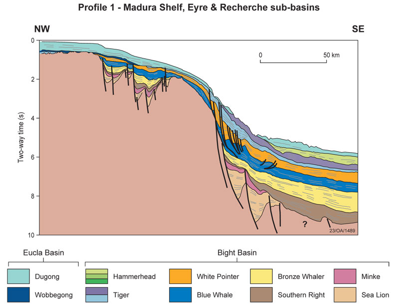
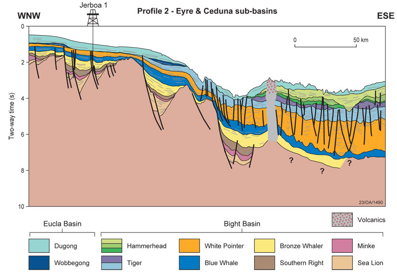
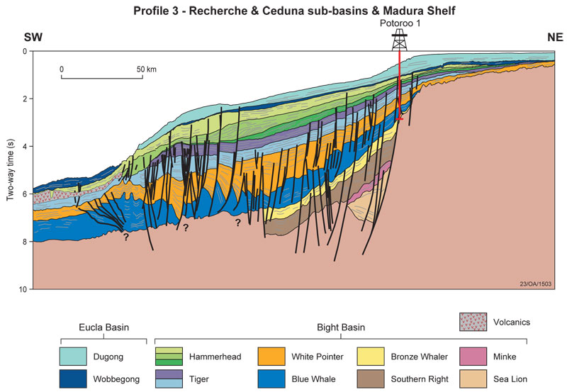
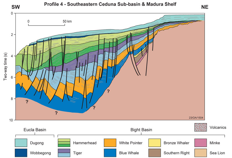
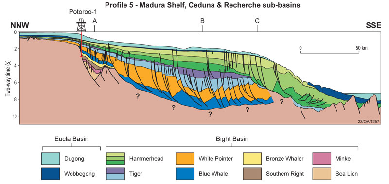
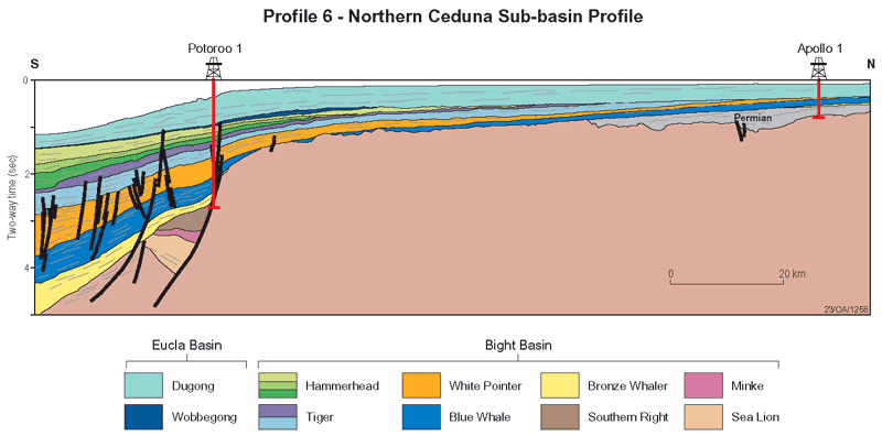
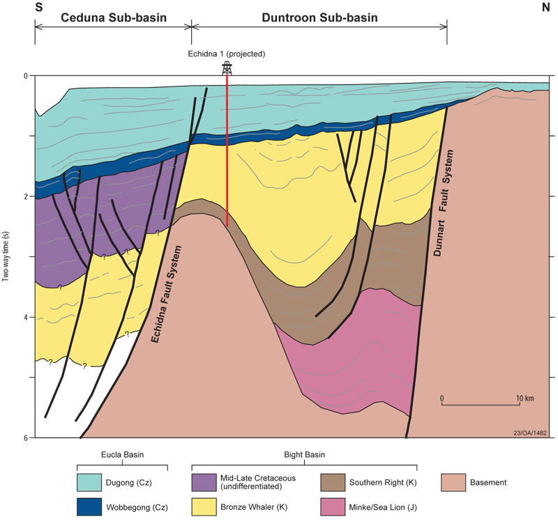
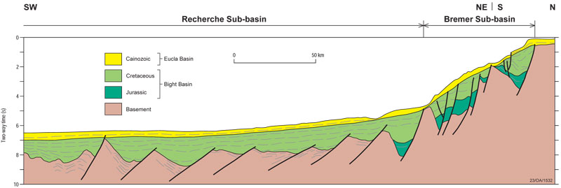
Regional cross-sections
Comparison of the cross-sections reveals differences in geometry, thickness and structural style within and between the sub-basins. Together, the eight profiles document the complex history of basin development and deformation along Australia's southern margin.
Eight regional cross-sections provide examples of the regional geometry, distribution, thickness and seismic character of Bight Basin sequences and their structural framework. Sequences on each of the cross-sections are colour-coded to the Sequence Stratigraphic correlation chart for ease of correlation. The eight regional cross-sections are:
Petroleum Systems and Hydrocarbon Potential
Exploration Status
The Bight Basin is a frontier basin. From the late 1960s to the early 1990s three discrete cycles of petroleum exploration were undertaken in the region. During this time only nine wells were drilled in the entire offshore portion of the basin. All wells were drilled within relatively thin successions on the margins of the basin and none encountered significant hydrocarbons.
The thickest depocentre, the Ceduna Sub-basin, covers an area of more than 155,000 km2, but prior to the current exploration round, only five petroleum exploration wells had been drilled within the sub-basin.
However, since 1999 the Great Australian Bight has been the focus for the release of exploration areas by the Australian Government. In 2000, a consortium comprising Woodside Petroleum, EnCana Corporation (then PanCanadian) and Anadarko Petroleum were awarded three large exploration permits in the Ceduna Sub-basin. Smaller permits were also awarded in the Duntroon Sub-basin to both the Woodside consortium and Australian explorer Santos Ltd.
The exploration programs associated with these permits include the acquisition of over 18,000 line kilometres of 2D seismic data, reprocessing of seismic data and geological and geophysical studies. Exploration interest focused largely on Late Cretaceous deltaic systems in the Ceduna and Duntroon Sub-basins.
In 2003, Woodside and partners drilled the unsuccessful Gnarlyknots 1, the first well in the basin since 1993. By November 2007 all exploration permits in the Bight Basin had been relinquished.
In early 2007 Geoscience Australia undertook a 3 week sampling survey onboard the RV Southern Surveyor which identified potential source rocks in the basin.
A total of 37 dredge samples of were taken, resulting in 259 samples that underwent organic geochemical analyses. These analyses have shown that a set of Cenomanian—Turonian age samples from the western Ceduna Sub-basin have excellent source rock characteristics, with high organic carbon contents (TOC 2.1%-6.2%) and the potential to generate liquid hydrocarbons (HI 274-479 mgHC/gTOC).
Petroleum systems
Several factors point to the presence of active petroleum systems in the Bight Basin. Many wells in the region had minor oil and/or gas indications such as fluorescence or cut and significant oil and gas shows were reported from Greenly 1 in the southern Ceduna Sub-basin. Fluid history analysis of samples from the base of Jerboa 1 in the Eyre Sub-basin has revealed the presence of a palaeo-oil accumulation. Analysis of the fluid inclusion oil points to a lacustrine source.
Wells in the Duntroon Sub-basin show clear indications of migration having occurred at several stratigraphic levels. Stranded coastal bitumens of natural origin have been recovered from Australia's southern shorelines for about 100 years. Many of these are asphaltites that are considered to have originated from a Jurassic to Early Cretaceous marine source rock. Recent geochemical and carbon isotopic studies have shown a correlation between the asphaltites, the Albian to Cenomanian Blue Whale supersequence of the Bight Basin and marine oil shales from the Albian Toolebuc Formation of the onshore Eromanga Basin. These results provide further evidence for the presence of at least one marine source rock unit in the region and strengthen the argument that the asphaltites originated in the Bight Basin.
Evidence for hydrocarbon generation in the Ceduna Sub-basin is also provided by the presence of active hydrocarbon seepage. The majority of seepage slicks, interpreted from Synthetic Aperture Radar data, occurs along the margins of the major depocentre, the Ceduna Sub-basin, in areas where significant Late Tertiary to Recent faulting extends to the seafloor or at onlap points of potential reservoir/carrier beds or seals. Hydrocarbon seepage correlates with regional drainage foci and patterns of late stage reactivation faults, which have focused laterally migrating hydrocarbons to produce active, probably episodic seepage at specific locations in the basin. Where these features are absent, seepage may be passive and/or be governed by long distance migration to points of seal failure.
The sequence stratigraphic framework developed by Geoscience Australia has allowed the identification of several potential hydrocarbon source intervals in the basin. These range from Late Jurassic syn-rift lacustrine shales to late Cretaceous marine and deltaic facies. While the Jurassic-early Cretaceous non-marine source intervals are important in the shallower, more proximal parts of the basin, the key to the petroleum prospectivity of the basin probably resides in the Late Cretaceous deltas and associated marine facies. The Cenomanian and Campanian-Maastrichtian deltas built out into a narrow restricted seaway prior to and immediately after the commencement of slow seafloor spreading between Australia and Antarctica in the Late Santonian.
This seaway would have provided an excellent environment for the development of organic-rich rocks. The marine shales of the Albian-Cenomanian Blue Whale Supersequence, the mobile substrate to the Cenomanian growth faults, have proven source rock potential and, on geochemical evidence, have been suggested as the possible source of the asphaltites that are regularly found along the southern margin of Australia. The White Pointer Supersequence contains both marine condensed sections and coaly deposits and has good to excellent source potential for both oil and gas.The preservation potential for organic-rich rocks would have been enhanced in the high accommodation setting of the growth-fault controlled depocentres.
In addition, seismic indications of thick shale-prone intervals within the dominantly marine Tiger Supersequence provide encouragement for the presence of Turonian age source rocks in the basin. The dominantly progradational Hammerhead Supersequence has excellent reservoir potential and there is a high likelihood of regionally extensive marine seal facies within the upper aggradational portion of the succession. The basinward thickening (up to 5000 metres) geometry of the Hammerhead is the key to the loading and maturation of successively younger source rocks. Modelling shows that generation and expulsion commenced from the Turonian onwards.
Finally, the Cenomanian growth faults set up a pattern of upward migration from mature source rocks into shallower reservoirs. These faults, which sole out in the Blue Whale shales, have been reactivated several times and formed the locus for the nucleation of new faults.
Key References
| Author(s) | Year | Title |
|---|---|---|
| Bein, J. and Taylor, M.L. | 1981 | The Eyre Sub-basin: Recent Exploration Results. Australian Petroleum Production and Exploration Association (APEA) Journal, Vol: 21, pp. 91-98 |
| Blevin, J.E., Totterdell, J.M., Logan, G.A., Kennard, J.M., Struckmeyer, H.I.M. and Colwell, J.B. | 2000 | Hydrocarbon Prospectivity of the Bight Basin - Petroleum Systems Analysis in a Frontier Basin. In: Second Sprigg Symposium - Frontier Basins and Frontier Ideas, Adelaide, 29 - 30 June, Geological Society of Australia, Abstracts, No. 60, pp. 24-29 |
| Boreham C.J., Krassay A.A. and Totterdell J.M. | 2000 | Geochemical Comparisons Between Asphaltites on the Southern Australian Margin and Cretaceous Source Rock Analogues. In: Hill, K.C. and Bernecker, T. (Editors) Eastern Australasian Basins Symposium: A Refocused Energy Perspective for the Future. Petroleum Exploration Society of Australia, Special Publication, pp. 531-541 |
| Brown, B., Miller, R.D., Gaina, C., Struckmeyer, H.I.M., Stagg, H.M.J., Symonds, P.A. | 2003 | Formation and Evolution of Australian Passive Margins; Implications for Locating the Boundary between Continental and Oceanic Crust. Special Paper - Geological Society of America, Vol. 372, pp. 223-243 |
| Cande, S.C. and Mutter, J.C. | 1982 | A Revised Identification of the Oldest Sea-floor Spreading Anomalies between Australia and Antarctica. Earth and Planetary Science Letters, Vol: 58, pp. 151-160 |
| Direen, N.G., Borissova, I.,Stagg, H.M.J., Colwell, J.B., and Symonds P.A. | 2007 | Nature of the Continent-ocean Transition Zone along the Southern Australian Continental Margin; A Comparison of the Naturaliste Plateau, SW Australia, and the Central Great Australian Bight Sectors. Geological Society Special Publications (2007), 282 239-263 |
| Edwards, D.S., McKirdy, D.M. and Summons, R.S. | 1999 | Enigmatic Asphaltites from the Southern Australian Margin: Molecular and Carbon Isotopic Composition. PESA Journal, Vol: 26, pp. 106-129 |
| Edwards, D.S., Struckmeyer, H.I.M., Bradshaw, M.T. and Skinner, J.E. | 1999 | Geochemical Characteristics of Australia-s Southern Margin Petroleum systems. APPEA Journal, Vol: 39, Issue 1, pp. 297-321 |
| Fraser, A.R. and Tilbury, L.A. | 1979 | Structure and Stratigraphy of the Ceduna Terrace Region, Great Australian Bight Basin. APEA Journal, Vol: 19, pp. 53-65 Hegarty, K.A., Weissel, J.K. and Mutter, J.C., 1988. Subsidence History of Australia-s Southern Margin: Constraints on Basin Models. AAPG Bulletin, Vol: 72, Issue 5, pp. 615-633 |
| Hegarty, K.A., Weissel, J.K. and Mutter, J.C. | 1988 | Subsidence History of Australia-s Southern Margin: Constraints on Basin Models. AAPG Bulletin, Vol: 72, Issue 5, pp. 615-633 |
| Hill, A. | 1991 | Revisions to the Cretaceous Stratigraphic Nomenclature of the Bight and Duntroon Basins, South Australia. Geological Survey of South Australia, Quarterly Geological Notes 120, pp. 2-20 |
| Hill, A.J. | 1995 | Bight Basin. In: Drexel, J.F. and Preiss, W.V. (Editors), The Geology of South Australia, Vol.2, The Phanerozoic. Geological Survey of South Australia, Bulletin Vol: 54, pp. 133-149 |
| King, S.J., Mee, B.C. | 2004 | The Seismic Stratigraphy and Petroleum Potential of the Late Cretaceous Ceduna Delta, Ceduna Sub-basin, Great Australian Bight. Petroleum Exploration Society of Australia Special Publication, Vol: 2, pp.62-73 |
| Krassay, A.A. and Totterdell, J.M. | 2003 | Seismic Stratigraphy of a Large, Cretaceous Shelf-margin Delta Complex, Offshore Southern Australia. AAPG Bulletin |
| Lisk, M., Hall, D., Ostby, J., Brincat, M.P. | 2001 | Addressing the Oil Migration Risks in the Great Australian Bight. In: Hill, K.C. and Bernecker, T. (Editors) Eastern Australasian Basins Symposium: a refocused energy perspective for the future. Petroleum Exploration Society of Australia, Special Publication, pp. 553-562 |
| Longley, I. | 2003 | Great Australian Bight; Recent Chronology of a Gnarly Area. PESA News, Vol: 62, pp.24-26 |
| Messent, B.E.J. | 1998 | Great Australian Bight: Well Audit. AGSO Record 1998/37 |
| Messent, B.E.J., Wilson, C. and Flynn, K. | 1996 | Assessment of the Seal Potential of Tertiary Carbonates, Duntroon Basin, South Australia. The APEA Journal, Vol: 36, Issue 1, pp. 233-241 |
| Norvick, M.S. and Smith, M.A. | 2001 | Mapping the Plate Tectonic Reconstruction of Southern and Southeastern Australia and Implications for Petroleum Systems. The APPEA Journal, Vol: 41, Issue 1, pp. 15-35 |
| Rollet, N., Fellows, M.E., Struckmeyer, H.I.M. and Bradshaw, B.E. | 2001 | Seabed Character Mapping in the Great Australian Bight, South and Southwest Region Project. Geoscience Australia Record 2001/42 |
| Ruble, T.E., Logan, G.A., Blevin, J.E., Struckmeyer, H.I.M., Ahmed, M. and Quezada, R.A. | 1999 | Geochemistry of Palaeo-oil in Jerboa-1, Eyre Sub-basin, Great Australian Bight. CSIRO Petroleum Confidential Report 99-060 |
| Ruble T.E., Logan G.A., Blevin J.E., Struckmeyer H.I.M., Liu K., Ahmed M., Eadington P.J. and Quezada, R.A. | 2001 | Geochemistry and Charge History of a Palaeo-oil Column: Jerboa-1, Eyre Sub-basin, Great Australian Bight. In: Hill, K.C. and Bernecker, T. (Editors) Eastern Australasian Basins Symposium: a refocused energy perspective for the future. Petroleum Exploration Society of Australia, Special Publication, pp. 521-529 |
| Sayers, J., Symonds, P., Direen, N.G. and Bernardel, G. | 2001 | Nature of the Continent-ocean Transition on the Non-volcanic Rifted Margin of the Central Great Australian Bight. In: Wilson, R.C.L., Whitmarsh, R.B., Taylor, B. and Froitzheim, N. (Editors), Non-volcanic rifting of continental margins: a comparison of evidence from land and sea. Geological Society, London, Special Publications, 187, 51-77 |
| Scott, D.L., Struckmeyer, H.I.M, Hatch, L., Cortese, A. and Desmond Fitzgerald & Associates | 2000 | Great Australian Bight: Basement Framework from Potential Field Studies and Regional Petroleum Geology. Geoscience Australia, GIS CD and reports (unpublished) |
| Smith, M.A. and Donaldson, I.F. | 1995 | The Hydrocarbon Potential of the Duntroon Basin. The APEA Journal, Vol: 35, Issue 1, pp. 203-219 |
| Smith, R. and Kamerling, P. | 1969 | Geological Framework of the Great Australian Bight. The APEA Journal, Vol: 9, Issue 2, pp. 60-65 |
| Somerville, R. | 2001 | The Ceduna Sub-basin - A Snapshot of Prospectivity. The APPEA Journal, Vol: 41, Issue 1, pp. 321-346 |
| Stagg, H.M.J., Cockshell, C.D., Willcox, J.B., Hill, A.J., Needham, D.J.L., Thomas, B., O'Brien, G.W. and Hough, L.P. | 1990 | Basins of the Great Australian Bight Region. Geology and Petroleum Potential. Bureau of Mineral Resources Australia, Continental Margins Program Folio 5 - OUT OF PRINT |
| Struckmeyer, H.I.M., Totterdell, J.M., Blevin, J.E., Logan, G.A., Boreham, C.J., Deighton, I., Krassay, A.A. and Bradshaw, M.T. | 2001 | Character, Maturity and Distribution of Potential Cretaceous Oil Source Rocks in the Ceduna Sub-basin, Bight Basin, Great Australian Bight. In: Hill, K.C. and Bernecker, T. (Editors), Eastern Australasian Basins Symposium. A Refocused Energy Perspective for the Future. Petroleum Exploration Society of Australia, Special Publication, pp. 543-552 |
| Struckmeyer, H.I.M., Williams, A.K., Cowley, R., Totterdell, J.M., Lawrence, G. and O-Brien, G.W. | 2002 | Evaluation of Hydrocarbon Seepage in the Great Australian Bight. The APPEA Journal, Vol: 42, Issue 1, pp. 371-386 |
| Tapley, D., Mee, B.C., King, S.J., Davis, R.C., Leischner, K.R. | 2005 | Petroleum Potential of the Ceduna Sub-basin: Impact of Gnarlyknots-1A. APPEA Journal, Vol: 45, Issue 1, pp.365-380 |
| Teasdale, J.P., Pryer, L.L., Stuart-Smith, P.G., Romine, K.K., Etheridge, M.A., Loutit, T.S., and Kyan, D.M. | 2003 | Structural Framework and Basin Evolution of Australia's Southern Margin. APPEA Journal, Vol: 43, Issue 1, pp. 13-37 |
| Tikku, A.A. and Cande, S.C. | 1999 | The Oldest Magnetic Anomalies in the Australian-Antarctic Basin: Are they Isochrons? Journal of Geophysical Research, Vol: 104, Issue B1, pp. 661-677 |
| Totterdell, J.M., Blevin, J.E., Struckmeyer, H.I.M., Bradshaw, B.E., Colwell, J.B. and Kennard, J.M. | 2000 | A New Sequence Framework for the Great Australian Bight: Starting with a New Slate. The APPEA Journal, Vol: 40, Issue 1, pp. 95-117 |
| Totterdell, J.M. and Krassay, A.A. | 2003 | The Role of Shale Deformation and Growth Faulting in the Late Cretaceous Evolution of the Bight Basin, Offshore Southern Australia. In: Van Rensbergen, P., Morley, C., Hillis, R. and Maltman, A. (editors), Subsurface sediment mobilisation. Geological Society of London, Special Publication, Vol. 216, pp. 429-442 |
| Totterdell, J.M. and Bradshaw, B.E. | 2004 | The Structural Framework and Tectonic Evolution of the Bight Basin. In: Boult, P.J., Johns, D.R. and Lang, S.C. (Eds), Eastern Australasian Basins Symposium II. Petroleum Exploration Society of Australia, Special Publication, pp. 41-61 |
| Veevers, J.J., Powell, C.McA. and Roots, S.R. | 1991 | Review of Seafloor Spreading around Australia. I. Synthesis of the Patterns of Spreading. Australian Journal of Earth Sciences, Vol: 38, Issue 4, pp. 373-89 |
| Walker, T.R. | 2007 | Deepwater and Frontier Exploration in Australia: Historical Perspectives, Present Environment and likely Future Trends. APPEA Journal, Vol: 47, Issue 1, pp. 15-38 |
| Willcox, J.B., Stagg, H.M.J., Davies, H.L. and others | 1988 | Rig Seismic Research Cruises 10 & 11: Geology of the Central Great Australian Bight region. Bureau Mineral Resources, Geology and Geophysics, Australia, Report 286 |
| Willcox, J.B. and Stagg, H.M.J. | 1990 | Australia-s Southern Margin: A Product of Oblique Extension. Tectonophysics, 173, 269-81 |