Geological Storage Studies
Page last updated:15 June 2026
One of our key roles in CCS over the past 20 or so years has been to identify and assess Australia’s potential and capacity to store carbon dioxide in our sedimentary basins. We have focused, for the most part, on national and basin-scale studies.
APCRC/GEODISC, 1999–2003
GEODISC was a national CO2 storage and infrastructure assessment project completed by Geoscience Australia in 2002 for the Australian Petroleum Cooperative Research Centre (APCRC, 1999–2003). Following a screening study of all of Australia’s sedimentary basins, the regional analysis program examined, in detail, the geological characteristics of nearly 90 sites and 15 regions and their suitability for geological storage, followed by risk and economic analyses and source-sink matching. Spatial data relating to the assessed sites can be accessed through our online data portal and the outcomes of the study are documented in detail in various publications from 2000–2004.
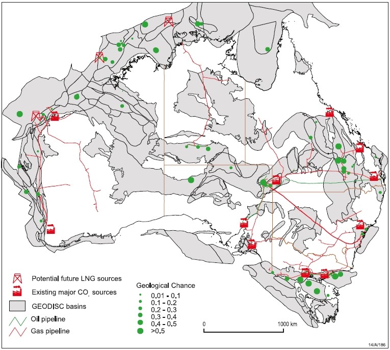
Sites examined for CO2 storage potential under the GEODSIC program and their geological prospectivity (geological chance) for CO2 storage (Bradshaw et al., 2002, figure 4).
CO2CRC basin assessments, 2003–2010
The Cooperative Research Centre for Greenhouse Gas Control Technologies (CO2CRC) was established in 2003 following the conclusion of the APCRC as a collaborative research and demonstration hub for CCS. As a partner in the CO2CRC, Geoscience Australia was involved in a range of collaborative research and development efforts related to CO2 geological storage, greenhouse gas monitoring and verification, and the development of a CO2 injection demonstration site in Australia (the CO2CRC Otway International Test Centre). Geological storage assessments were completed for, among others, the Otway, Galilee, Bowen, Gippsland, Sydney, Darling, Perth and Collie Basins (see publications). Other research included completion of the fault seal integrity project.
Following its conclusion under the cooperative research centre, CO2CRC formed a not-for-profit research organisation. Geoscience Australia as a partner, continues to work with CO2CRC, members and stakeholders on geological storage and greenhouse gas monitoring related projects. For more information, see our publications and the CO2CRC website.
National carbon mapping and infrastructure plan (NCMIP), 2009
A national and basin-scale assessment of Australia’s potential and capacity to transport and store CO2 was completed in 2009 for the Carbon Storage Taskforce (under the National Low Emissions Coal Initiative - NLECI). The high-level assessment took into consideration geological characteristics and other factors in order to determine the potential, capacity and ranking of sedimentary basins for CO2 geological storage. As part of this project, the CO2 Pipeline Route Planning Tool was implemented to model optimal pathways between CO2 emissions sources and potential CO2 storage sites. Read the full report, and access the basin ranking spatial data and the pipeline tool through our online data portal.
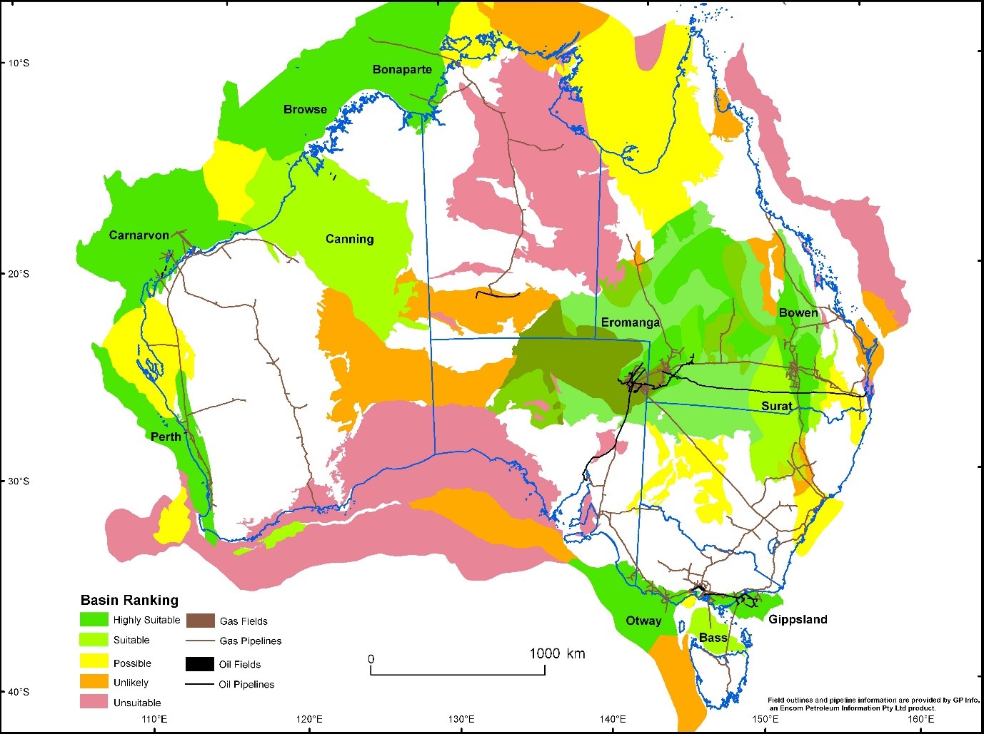
Australia’s basins ranked for CO2 storage potential (NCMIP, 2009, Figure 18).
National CO2 infrastructure plan (NCIP), 2012–2016
This program was established under the National Low Emission Coal Initiative to accelerate identification and development of CO2 storage sites close to major emission sources (NLECI). Under the NCIP program, four regions were examined in detail to determine their potential for CO2 storage, including acquisition of new geological data.
For more details on each of these projects, as well as related publications and data packages, please see:
- Petrel Sub-basin (Bonaparte Basin) CO2 Storage Assessment
- Gippsland Basin CO2 Storage Assessment
- Vlaming Sub-basin (Perth Basin) CO2 Storage Assessment
- Browse Basin CO2 Storage Project
- Onshore Carbon Storage Project (NSW, WA)
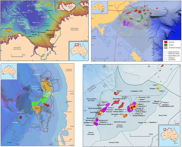
Offshore regions assessed for CO2 storage potential under the NCIP program. Clockwise from top left: Bonaparte Basin; Gippsland Basin; Browse Basin; Vlaming Sub-basin.
Trusted Environmental and Geological Information Program 2021–2023
The Trusted Environmental and Geological Information program (TEGI) is providing better and more streamlined access to information and data for geological basins prospective for energy, carbon capture and storage, groundwater and minerals. For more information visit the TEGI website.
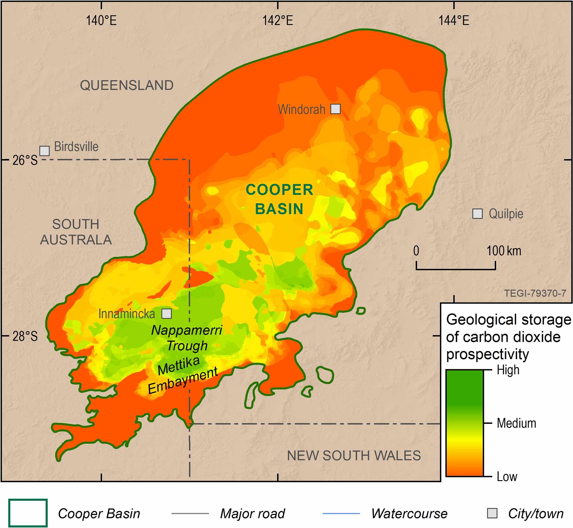
Geological storage of CO2 prospectivity map for the Toolachee Play interval.
Exploring for the Future Program 2020–2024
The program's vision was to support a strong economy, resilient society and sustainable environment for the benefit of all Australians through an integrated geoscientific understanding of our mineral, energy and groundwater potential. This included assessment of CO2 geological storage potential in strategic areas. For more information please see Energy Resource Assessment and Carbon (CO2) Storage in Residual Oil Zones.
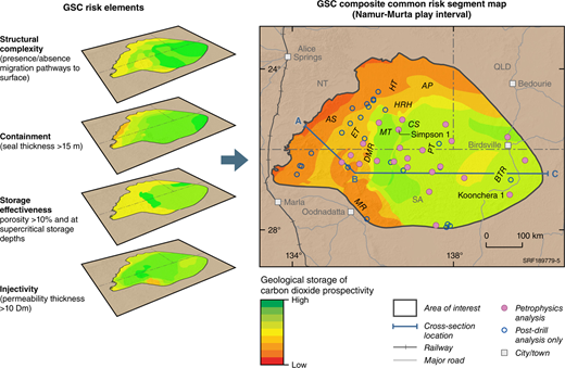
Geological Storage of CO2 (GSC) composite common risk segment map for the Namur-Murta play interval derived by stacking (multiplying) the four risk element CRS map layers of injectivity, storage effectiveness, containment and structural complexity.
Significant geological storage studies
State Government agencies, CSIRO, CO2CRC, universities and industry have completed many studies and R&D programs on the various aspects of CCS. These include:
- Queensland Government’s Queensland CO2 Storage Geological Atlas 2010
- Western Australia’s CCS program and Carbon Dioxide Storage Atlas (2014)
- NSW Government’s New South Wales precompetitive CO2 Storage Assessment Project
- Victorian Government’s ongoing CarbonNet project and related CCS work
- CO2CRC geological storage research projects