Carnarvon Basin
Page last updated:29 August 2023
Note: refer to the Acreage Release basins page for updated information on the Northern Carnarvon, Southern Carnarvon basins.
Basin Details and Geological Overview
The Carnarvon Basin is an epicratonic, faulted and folded Phanerozoic basin which encompasses over 1000km of the west and northwest coast of Western Australia, from Geraldton to north of Port Headland. The onshore part of the Carnarvon Basin covers about 115 000km2 and the offshore part covers approximately 535 000km2 with water depths up to 3500 metres. The basin is elongated northeast-southwest, is transitional southwards into the Perth Basin and northeastwards into the Offshore Canning and Roebuck basins.
The Carnarvon Basin contains a maximum of 15km of Palaeozoic to Recent sedimentary infill. The basin can be divided into the which comprises up to 15km of largely Mesozoic sedimentary rocks and the Southern Carnarvon Basin which contains up to 7km of largely Palaeozoic sedimentary rocks.
Northern Carnarvon Basin
The Northern Carnarvon Basin encompasses the Exmouth Plateau, Wombat Plateau (on the northern part of the Exmouth Plateau), Investigator Sub-basin, Rankin Platform, Exmouth Sub-basin, Barrow Sub-basin, Dampier Sub-basin, Beagle Sub-basin, Enderby Terrace, Peedamullah Shelf and the Lambert Shelf.
The Palaeozoic-Recent Northern Carnarvon Basin, is a large, mainly offshore basin on the northwest shelf of Australia. The basin is Australia's premier hydrocarbon province where the majority of deepwater wells have been drilled (greater than 500 metres water depth). Since exploration drilling commenced in 1953, some 754 exploration wells have been drilled (at Dec 2001) and 145 GL of oil, 52 GL of condensate and 207 BCM of gas have been produced. Remaining known reserves are 76 GL of oil, 93 GL of condensate and 604 BCM of gas.
The major basin faults trend north or northeast and define a series of structural highs and sub-basins. The basin developed during four successive periods of extension and thermal subsidence. The first phase, Silurian to Permian, developed as a series of intracratonic basins during the breakup of Gondwana along the western margin of Australia. Subsequent Early Jurassic extension initiated the four main depocentres - the Exmouth, Barrow, Dampier and Beagle Sub-basins. A third extension phase in the Middle Jurassic resulted in the seafloor spreading in the Argo Abyssal Plain to the north and the fourth Tithonian-Valanginian rifting phase culminated in the creation of the Gascoyne-Cuvier abyssal plains to the west and south. The extensive deep-water (800 - 3000 metres) Exmouth Plateau forms a bathymetric plateau outboard of the main depocentres and developed in response to thermal sag after Valanginian breakup.
The main depocentres contain up to 15 km of sedimentary infill. Triassic to Early Cretaceous deposition is dominantly siliciclastic deltaic to marine, whereas slope and shelfal marls and carbonates dominate the Mid-Cretaceous to Cainozoic section. The carbonate-rich sediments were deposited as a series of northwestward prograding wedges as the region continued to cool and subside. This resulted in deep burial of the underlying Mesozoic source and reservoir sequences in the inboard part of the basin.
Almost all the hydrocarbon resources are reservoired within the Upper Triassic, Jurassic and Lower Cretaceous sandstones beneath the regional Early Cretaceous seal.
Southern Carnarvon Basin
The Ordovician-Permian Southern Carnarvon Basin is a large, mainly onshore basin on the Western Australian poly-phased margin. About 30 exploration wells have been drilled including just two offshore wells. Minor gas shows have been encountered in some wells but there are no discoveries to date. Exploration has yet to confirm the potential of the area.
The basin consists of the Gascoyne, Merlinleigh, Bidgemia and Byro Sub-basins and Bernier Platform and is flanked to the east by the Archaean Pilbara Block. The Gascoyne Sub-basin comprises a broad, low-amplitude syncline with two distinct depocentres that contain up to 5 km of Ordovician-Devonian strata and a thin Cretaceous-Cainozoic cover. The other three sub-basins contain up to 7 km of predominantly Permo-Carboniferous sediments with a Mesozoic veneer, which thickens to the north and west. Faults trend northerly and northwesterly.
The structural evolution of the Southern Carnarvon Basin occurred mainly from the Ordovician-Silurian to the Late Permian. The basin was initiated as an epicratonic rift in the Late Ordovician-Early Silurian and rifting was accompanied by uplift of the Pilbara Block. Shallow marine to tidal flat conditions were established in the Late Silurian. Following a period of non-deposition during the Early Devonian, Devonian and Early Carboniferous sediments were deposited across a shallow marine shelf and an interior-sag basin. Marine conditions were terminated in the mid-Carboniferous by a major tectonic episode, the collision between Gondwanaland and Laurasia to form the super-continent Pangea. Most of the basin and the adjacent Pilbara Block were uplifted at this time. Renewed rifting in the Late Carboniferous to Early Permian activated the Wandagee, Kennedy Range and Darling Fault systems and initiated a second phase of deposition in the Merlinleigh, Byro and Bidgemia Sub-basins. Glacial conditions dominated the Late Carboniferous and Early Permian.
Source rock data is sparse, but indicates excellent gas-prone source rocks in the Early Permian and excellent/good oil-prone source rocks in the Early Ordovician, Late Devonian, Early Carboniferous and Late Permian. Reservoir targets are the Ordovician Tumblagooda Sandstone, the Devonian Kopke Sandstone, Nannyarra Sandstone and Point Maud Member reefs and the Permian Moogooloo Sandstone, Byro Group equivalent sandstones and Chinty Formation.
Further information on the Southern Carnarvon Basin can be found in the Western Australia Atlas of Petroleum Fields in the onshore Carnarvon Basin (Ellis and Jonasson, 2001).
- ProvExplorer - Carnarvon Basin Details and Geological Overview
Stratigraphy
Northern Carnarvon Basin
The stratigraphic correlation chart of the Northern Carnarvon Basin reflects the subsidence history of this basin. It has been dominated by simple thermal sag following the creation of the Exmouth, Barrow, Dampier and Beagle Sub-basins during the Early to Middle Jurassic rifting event. The simple thermal-sag model accounts for the post-rift sedimentary architecture of the Northern Carnarvon Basin, notably in areas starved of sediments. The depositional environments were dominantly siliciclastic deltaic to marine throughout the Triassic to Cretaceous. Carbonates dominate the Late Cretaceous to Cainozoic sedimentary sequences forming a blanket over the entire basin.
Regional Cross-sections
Northern Carnarvon Basin
Five regional cross-sections have been selected from Geoscience Australia's regional deep seismic grid. The five profiles provide examples of the regional geometry, distribution, thickness and seismic character of major sequences and their structural framework. The five regional cross-sections are:
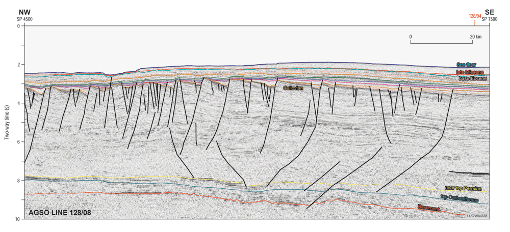
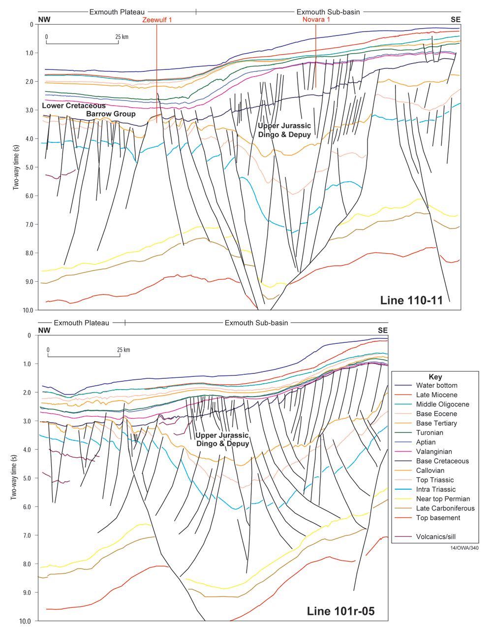
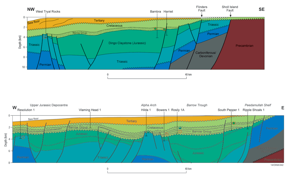
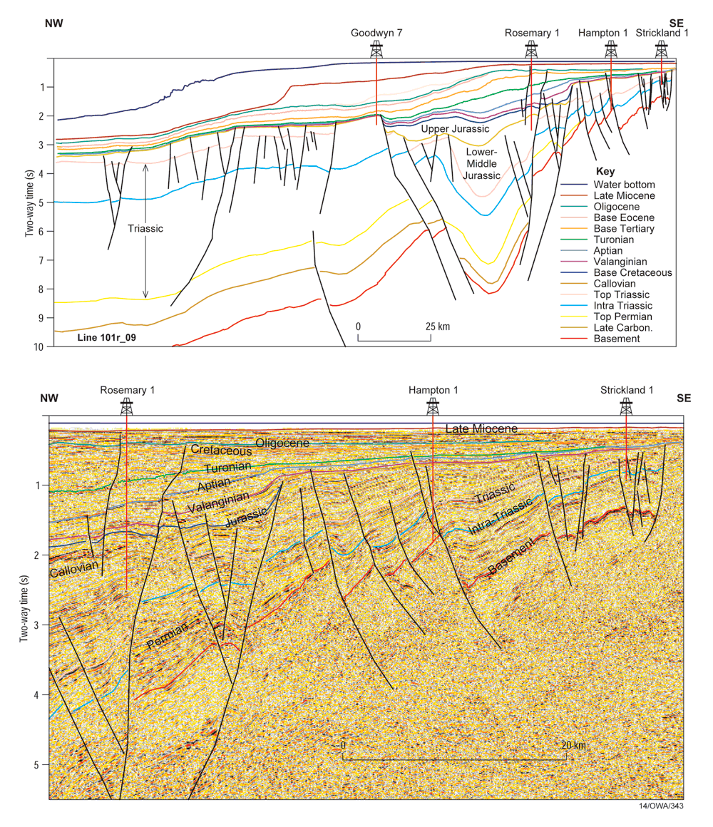
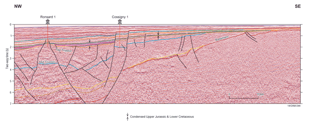
Comparison of the five cross-sections reveals differences in geometry, thickness and structural style between the sub-basins. Together, the profiles document the complex history of development and deformation of the Northern Carnarvon Basin.
Petroleum Systems and Hydrocarbon Potential
Northern Carnarvon Basin
Exmouth Sub-basin
At the end of 2001, the Exmouth Sub-basin contained 16 field discoveries and 74 exploration wells with a historical technical success rate of 22% and 8% success rate for fields greater than 20 million boe. The sub-basin is estimated to contain reserves of 1.2 tcf gas, 0 million bbls condensate and 278 million bls oil (Longley et al., 2002).
Recent successful discoveries in the central western part of the sub-basin have provided considerable encouragement for deepwater exploration, although the area has a biodegradation risk. 1947 Beginning of petroleum exploration in the Exmouth area. First exploration lease granted on the North West Cape.
| Year | Event |
|---|---|
| 1947 | Beginning of petroleum exploration in the Exmouth area. First exploration lease granted on the North West Cape. |
| 1953 | Discovery of oil at Rough Range-1. First well in Australia to flow oil at the surface which stimulated interest in the area and led to further onshore petroleum exploration. |
| 1970-80s | Acquisition of marine seismic data.
|
| 1990s | Discovery of the Griffin (1989), Chinook/Scindian (1990/1992) and Ramilies (1991) oil and gas fields.
|
| 1992-1994 | Discovery of top Barrow play on the Alpha Arch and the Macedon/Pyrenees field. This structure, however was first tested by WAPET during 1972 and 1975 with West Murion-1A and the extent of the hydrocarbon accumulation was not recognised and WAPET relinquished the acreage. |
| 1998-2000 | Recent discoveries of oil accumulations in central western part of the sub-basin:
|
Barrow Sub-basin
| Year | Event |
|---|---|
| 1954 | Beginning of exploration in the Barrow area. |
| 1964 | Drilling of Barrow-1 after seismic refraction survey. |
| 1968 | Exploration turned to the Rankin Platform after the release of BMR's geophysical survey and subsequent recognition of tectonic elements. |
| 1970s | Discovery of the North Rankin Gas field (1971) in the adjacent Dampier Sub-basin.
|
| 1981 | Gorgon was drilled on the Rankin Platform, which penetrated another major gas/condensate accumulation in the Triassic Mungaroo Formation. |
| Early 1980s | A large number of wells were drilled and resulted in oil discoveries;
|
| Late 1980s | Although the number of offshore exploration wells significantly decreased, a number of major discoveries occurred.
|
| 1990s | Drilling focused on extending the reserves from existing fields.
The Linda-1 well, located approximately 4 km north-west of the Gipsy/Rose/Lee fields, intersected a 91m gas-condensate column in Jurassic Biggada Sandstones and represented the first purely stratigraphic discovery of significant size in Oxfordian sandstones in the Carnarvon Basin. Tanami-4, located south of Linda-1, encountered an 18.9 metres thick gross oil column at the top of the Flag Sandstone and has been suspended as a future oil producer. Recent drilling west of the Greater Gorgon field has resulted in five significant gas discoveries; Geryon-1, Orthrus-1, Urania-1, Maenad-1 and Io-1 and Janz-1.
|
| 2000-2002 | A string of recent discoveries have been made in the Harriet area, including the North Alkimos oil and gas discovery. |
| Early 2001 | Simpson, South Plato and Gibson oil discoveries. |
Dampier Sub-basin
| Year | Event |
|---|---|
| 1968 | First discovered in the Dampier Sub-basin.
|
| 1970s | Boost in exploration and discovery of numerous gas fields:
|
| 1980s | Exploration activity increased.
|
| 1990s | Improvement in sub-surface imaging through 3D seismic acquisition and processing.
|
| 1999-2000 | Several deep-water wells (water depths greater than 500m) were drilled.
|
Petroleum system charts (Northern Carnarvon Basin)
Two petroleum systems are recognised in the Northern Carnarvon Basin where the Upper Jurassic Dingo Claystone and Triassic Locker Shale - Mungaroo formations are effective source rocks. The petroleum system for the Exmouth, Barrow and Dampier Sub-basins show that almost all of the oil and gas accumulations are reservoired within Upper Triassic, Jurassic and Lower Cretaceous sandstones beneath the regional Early Cretaceous seal.
Key references
| Author(s) | Year | Title |
|---|---|---|
| Apache Energy Ltd | 2002 | Recent discoveries in the Barrow Sub-basin: Linda, Gipsy, North Gipsy, Rose, Lee, Gibson, Simpson, South Plato, Double Island, Victoria, Little Sandy, Pedirka and Hoover, The Sedimentary Basins of Western Australia, ed. M. Keep and S. Moss, Proceedings Western Australian Basins Symposium 3, Perth, 477-490. |
| Barber, P.M. | 1988 | The Exmouth Plateau deep water frontier: a case history. The North West Shelf, Australia. Proceedings of the North West Shelf Symposium, Perth, Western Australia, 10-12 August, 1988, edited by P.G. Purcell and R.R. Purcell. Perth: PESA., 173-187 |
| Blevin, J.E., Stephenson, A.E. and West, B.G. | 1994 | Mesozoic structural development of the Beagle Sub-basin - implications for the petroleum potential of the northern Carnarvon Basin. IN: PURCELL, P.G. and PURCELL, R.R. (Editors), The Sedimentary Basins of Western Australia, Proceedings of the Petroleum Exploration Society Symposium, Perth, 1994, 479-496. |
| Bradshaw, J., Sayers, J., Bradshaw, M., Kneale, R., Ford, C., Spencer, L. and Lisk, M. | 1998 | Palaeogeography and its Impact on the petroleum systems of the North West Shelf, Australia. IN: Purcell, P.G. and Purcell, R.R. (Editors), The Sedimentary Basins of Western Australia 2. Proceedings of Petroleum Exploration Society of Australia Symposium, Perth, 95-121. |
| Bradshaw, M.T., Bradshaw, J., Murray, A.P., Needham, D.J., Spencer, R.E., Summons, R.E., Wilmont, J. and Winn, S. | 1994 | Petroleum systems in West Australian Basins. IN: Purcell, P.G. and Purcell, R.R. (Editors), The Sedimentary Basins of Western Australia. Proceedings of Petroleum Exploration Society of Australia Symposium, Perth, 93-118. |
| Ellis, G.K. and Jonasson, K.E. | 2001 | Western Australia - Atlas of Petroleum Fields - Onshore Carnarvon Basin, Department of Mineral and Petroleum Resources, Petroleum Division, Vol. 2, Part 2. |
| Ghori, K.A.R. | 1999 | Silurian-Devonian petroleum source-rock potential and thermal history, Carnarvon Basin, Western Australia. Western Australia. Geological Survey. Report, 72. iv, 88 pages. |
| Ghori, K.A.R. | 1998 | Petroleum generating potential and thermal history of the Palaeozoic, Carnarvon Basin, Western Australia. The sedimentary basins of Western Australia 2. Proceedings of the West Australian Basins Symposium, sponsored by the West Australian Branch of the Petroleum Exploration Society of Australia, Perth, August 30-September 2, 1998, edited by P.G. Purcell and R.R. Purcell. Perth: PESA., 553-567. |
| Gorter, J.D., Mory, A. and Nicoll, R.S. | 1998 | Sequence stratigraphy and hydrocarbon potential of the Middle to Upper Devonian sequences in the southern Carnarvon Basin, Western Australia. The sedimentary basins of Western Australia 2. Proceedings of the West Australian Basins Symposium, sponsored by the West Australian Branch of the Petroleum Exploration Society of Australia, Perth, August 30-September 2, 1998, edited by P.G. Purcell and R.R. Purcell. Perth: PESA., 569-588. |
| Hocking, R.M. | 1988 | Regional geology of the Northern Carnarvon Basin. IN: Purcell, P.G. and Purcell, R.R. (Editors), The North West Shelf, Australia. Proceedings of Petroleum Exploration Society of Australia Symposium, Perth, 97-114. |
| Hocking, R.M. | 1994 | Subdivisions of Western Australia Neoproterozoic and Phenerozoic Sedimentary Basins. Geological Survey of Western Australia Record 1994/4. |
| Iasky, R.P. and Mory, A.J. | 1999 | Geology and petroleum potential of the Gascoyne Platform, southern Carnarvon Basin, Western Australia. Western Australia. Geological Survey. Report, 69. iv, 46 pages. |
| Iasky, R.P., Mory, A.J. and Shevchenko, S.I. | 1998 | A structural interpretation of the Gascoyne Platform, southern Carnarvon Basin, WA. The sedimentary basins of Western Australia 2. Proceedings of the West Australian Basins Symposium, sponsored by the West Australian Branch of the Petroleum Exploration Society of Australia, Perth, August 30-September 2, 1998, edited by P.G. Purcell and R.R. Purcell. Perth: PESA., 589-598. |
| Karner, G.D. and Driscoll, N.W. | 1999 | Style, timing and distribution of tectonic deformation across the Exmouth Plateau, northwest Australia, determined from stratal architecture and quantitative basin modelling. Continental tectonics, edited by C. Mac Niocaill and P.D. Ryan. London: The Geological Society of London., 271-311. |
| Longley, I.M., Buessenschuett, C., Clydsdale, L., Cubitt, C.J., Davis, R.C., Johnson, M.K., Marshall, N.M., Murray, A.P., Somerville, R., Spry, T.B. and Thompson, N.B. | 2002 | The North West Shelf of Australia - a Woodside Perspective, The Sedimentary Basins of Western Australia, ed. M. Keep and S. Moss, Proceedings Western Australian Basins Symposium 3, Perth, 28-88. |
| Mory, A.J., Nicoll, R.S. and Gorter, J.D. | 1998 | Lower Palaeozoic correlations and thermal maturity, Carnarvon Basin, WA. The sedimentary basins of Western Australia 2. Proceedings of the West Australian Basins Symposium, sponsored by the West Australian Branch of the Petroleum Exploration Society of Australia, Perth, August 30-September 2, 1998, edited by P.G. Purcell and R.R. Purcell. Perth: PESA., 599-611. |
| Romine, K.K., Durrant, J.M., Cathro, D.L. and Bernardel, G. | 1997 | Petroleum play element predication for the Cretaceous-Tertiary basin phase, Northern Carnarvon Basin. Australian Petroleum Production & Exploration Association (APPEA) Journal 37(1), 315-339. |
| Stagg, H.M.J., & Colwell, J.B. | 1994 | The structural foundations of the northern Carnarvon Basin. In Purcell, P.G. & R.R., (Editors), 1994. The Sedimentary Basins of Western Australia: Proceedings of Petroleum Exploration Society of Australia Symposium, Perth, 1994, 349-372. |
| Tindale, K., Newell, N., Keall, J., Smith, N. | 1998 | Structural evolution and charge history of the Exmouth Sub-basin, northern Carnarvon Basin, Western Australia. IN: Purcell, P.G. and Purcell, R.R. (Editors), The Sedimentary Basins of Western Australia 2. Proceedings of Petroleum Exploration Society of Australia Symposium, Perth, 447-72. |
| Veenstra, E. | 1985 | Rift and drift in the Dampier Sub-basin, a seismic and structural interpretation. APEA Journal 25(1), 177-189. |