Knowledge article What are Australia's maritime zones?
Page last updated:27 August 2026
Australia's maritime zones define where different rights, responsibilities and obligations apply across Australia's maritime jurisdiction. These zones are derived from international and national legislation, as well as arising out of treaties and agreements with neighbouring countries.
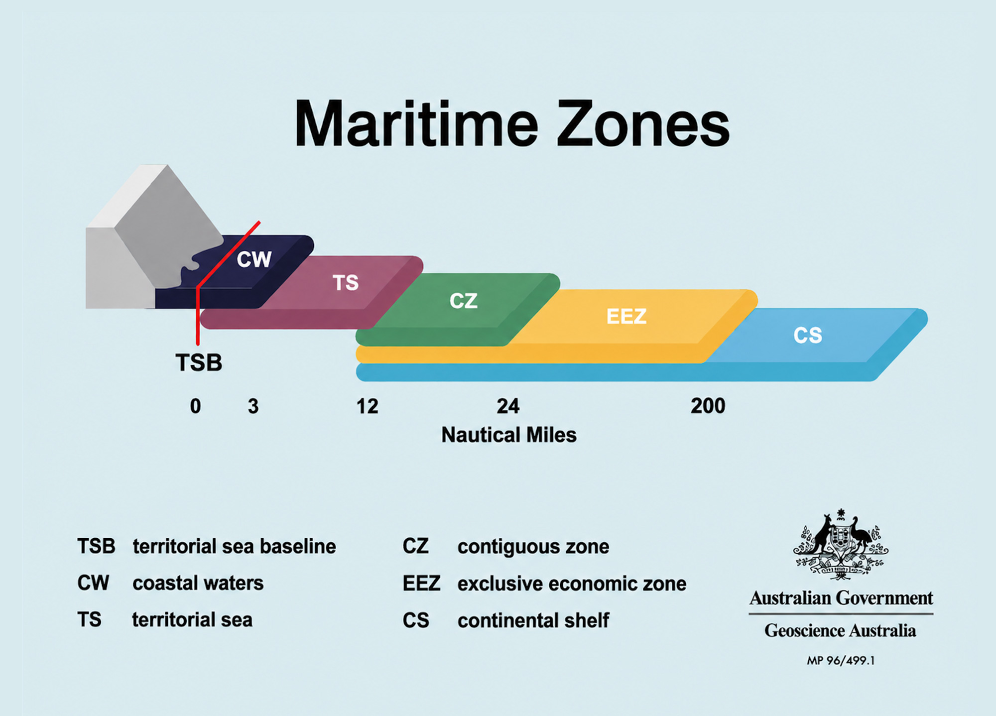
The majority of Australia’s maritime jurisdiction is made up of zones with varying levels of sovereignty and sovereign rights.
These are calculated from an established territorial sea baseline (TSB) around Australia and its remote offshore territories, in accordance with United Nations Convention on the Law of the Sea (UNCLOS) and Australian domestic law.
Learn more about how Australia’s maritime boundaries are calculated
Summary of maritime zones
- Coastal waters – a zone that extends 3 nautical miles from the baseline, plus waters on the landward side of the baseline (internal waters) that are not within the constitutional limits of the States and Northern Territory, where jurisdiction is vested in the adjacent State or Territory.
- Territorial sea — extends up to 12 nautical miles from the baseline, where Australia exercises sovereignty, subject to rights including innocent passage of foreign vessels.
- Contiguous zone — extends beyond the territorial sea up to 24 nautical miles from the baseline where Australia may exercise limited enforcement activities.
- Exclusive economic zone (EEZ) — extends up to 200 nautical miles from the baseline, where Australia has sovereign rights to explore, exploit, conserve and manage natural resources, and jurisdiction over activities such as marine scientific research and protection of the marine environment.
- Continental shelf – extends up to 200 nautical miles from the baseline and, where the continental margin extends further, may extend beyond 200 nautical miles. Where Australia has sovereign rights to explore and exploit the natural resources of the seabed.
Get more detail
The guide below provides further detail about Australia's maritime zones in plain language. It is intended as a practical reference and does not replace the legal definitions contained in legislation or international agreements.
Maps, web services and spatial datasets provide technical representations of maritime limits and boundaries. They should be read with the relevant legislation, proclamations, treaties and international law rules. If there is any inconsistency between a spatial dataset and a legal instrument, the legal instrument prevails.
The term territorial sea baseline (TSB) refers to the line from which the seaward limits of Australia's maritime zones are measured. These include the breadth of the territorial sea; the seaward limits of the contiguous zone, the exclusive economic zone and, in some cases, the continental shelf.
The territorial sea baseline may be of various types depending upon the shape of the coastline in any given locality:
- The normal baseline corresponds with the low water line along the coast, including the coasts of islands. Under the Convention, normal baseline can be drawn around low tide elevations which are defined as naturally formed areas of land surrounded by and above water at low tide but submerged at high tide, provided they are wholly or partly within 12 nautical miles of the coast. For Australian purposes, normal baseline corresponds to the level of Lowest Astronomical Tide (LAT).
- Straight baselines are a system of straight lines joining specified or discrete points on the low-water line, usually known as straight baseline end points. These may be used in localities where the coastline is deeply indented and cut into, or where there is a fringe of islands along the coast in its immediate vicinity.
- Bay or river closing lines are straight lines drawn between the respective low-water marks of the natural entrance points of bays or rivers.
Waters on the landward side of the baseline are internal waters for the purposes of international law.
Coastal waters is a belt of water between the limits of the Australian States and the Northern Territory and a line 3M seaward of the territorial sea baseline*. Jurisdiction over the water column and the subjacent seabed is vested in the adjacent State or Territory as if the area formed part of that State or Territory.
This, and other arrangements for the management of offshore resources such as fisheries and petroleum, are defined by the Offshore Constitutional Settlement (OCS). The principal legislation implementing the OCS (Coastal Water (State Powers) Act 1980, Coastal Waters (State Title) Act 1980, Coastal Waters (Northern Territory Powers) Act 1980 and the Coastal Waters (Northern Territory Title) Act 1980) entered into force in January 1982 and February 1983.
* The TSB used to determine coastal waters does not include low tide elevations greater than 3M from the coastline or islands.
The territorial sea is a belt of water not exceeding 12M in width measured from the territorial sea baseline. Australia's sovereignty extends to the territorial sea, its seabed and subsoil, and to the air space above it. This sovereignty is exercised in accordance with international law as reflected in the Convention. The major limitation on Australia's exercise of sovereignty in the territorial sea is the right of innocent passage for foreign ships. The territorial sea around certain islands in the Torres Strait is 3M.
The contiguous zone is a belt of water contiguous to the territorial sea, the outer limit of which does not exceed 24M from the territorial sea baseline. In this zone, Australia may exercise control necessary to prevent and punish infringement of its customs, fiscal, immigration or sanitary laws and regulations within its territory or territorial sea.
The exclusive economic zone (EEZ) is an area beyond and adjacent to the territorial sea. The outer limit of the exclusive economic zone cannot exceed 200M from the baseline from which the breadth of the territorial sea is measured.
In the EEZ, Australia has sovereign rights for the purpose of exploring and exploiting, conserving and managing all natural resources of the waters suprajacent to the seabed and of the seabed and its subsoil together with other activities such as the production of energy from water, currents and wind.
Jurisdiction also extends to the establishment and use of artificial islands, installations and structures, marine scientific research, the protection and preservation of the marine environment, and other rights and duties.
The Australian EEZ is defined in the Seas and Submerged Lands Act 1973 ('the SSL Act' - including the amendments to that Act made by the Maritime Legislation Amendment Act 1994).
The outer limit of the Australian EEZ is set out in the Proclamation under the SSL Act which was made on 26 July 1994 and published in Gazette S290 on 29 July 1994. That proclamation entered into force on 1 August 1994. The outer boundary is mostly 200M from the territorial sea baselines.
However, the Proclamation pulls the boundary back to less than 200M in areas of agreed or potential delimitation with other countries. The metes and bounds definitions where the boundary has been pulled back are taken from Australia's maritime delimitation agreements with other countries and, where no such agreement exists, largely follow the Fisheries Management Act 1991 ('the FMA Act') 'excepted waters' Proclamation which was published in Gazette No.S52 of 14 February 1992.
Area of Australia's exclusive economic zone (EEZ)
| EEZ | Area (million km²) |
|---|---|
| Heard and McDonald Islands | 0.41 |
| Cocos (Keeling) Islands | 0.46 |
| Christmas Island | 0.27 |
| Norfolk Island | 0.43 |
| Macquarie Island | 0.47 |
| Australia | 5.97 |
| Australian Antarctic Territory | 2.06 |
| Total | 10.07 |
Source: AMB 2020. Calculated in July 2026
The Australian Fishing Zone (AFZ) is defined as follows in the Fisheries Management Act 1991 (FMA) (including the amendments to that Act made by the Maritime Legislation Amendment Act 1994).
Australian Fishing Zone means:
- The waters adjacent to Australia within the outer limits of the exclusive economic zone; and
- The waters adjacent to each external territory within the outer limits of the exclusive economic zone; but does not include:
- Coastal waters of, or waters within the limits of, a State or internal Territory; or
- Waters that are 'excepted waters'
The outer limit of the AFZ is the same as the outer limit of the EEZ other than in places where the 'excepted waters' Proclamation in Gazette No.S52 of 14 February 1992 remains relevant (see paragraph (d) of the definition). The 'excepted waters' Proclamation remains relevant in two areas — in the Torres Strait and in the waters adjacent to the Australian Antarctic Territory (Parts 5 and 6 of the 1992 Proclamation). The other parts of the 1992 'excepted waters' Proclamation have been rendered redundant by the Proclamation of the outer limits of the EEZ which entered into force on 1 August 1994. They have been rendered redundant because they largely cover the same lines as are used in the 1994 EEZ Proclamation.
The continental shelf is the area of the seabed and subsoil which extends beyond the territorial sea to a distance of 200M from the territorial sea baseline and beyond that distance to the outer edge of the continental margin as defined in Article 76 of the Convention. The continental shelf is largely coextensive with the exclusive economic zone within 200M from the territorial sea baselines (there are certain areas between Australia and Indonesia and Australia and Papua New Guinea where they are not coextensive).
Australia has sovereign rights over the continental shelf for the purposes of exploring and exploiting the mineral and other non-living resources of the seabed and subsoil, together with sedentary organisms. In this area, Australia also has jurisdiction with regard to marine scientific research as well as other rights and responsibilities.
In November 2004, Australia made its submission to the United Nations Commission on the Limits of the Continental Shelf (CLCS) on the outer limit of its continental shelf beyond 200 nautical miles, becoming one of only three countries to meet the original deadline established under UNCLOS. The submission included nine discrete areas, as well as a tenth area relating to the Australian Antarctica Territory, which Australia requested the CLCS not consider at that time. The CLCS examined the nine areas between 2005 and 2008.
Following recommendations made by the CLCS on 9 April 2008, Australia confirmed the outer limit to its continental shelf extending beyond 200 nautical miles from the territorial sea baseline associated with both the continent and its remote offshore territories. Australia declared its continental shelf limits for the areas that received positive recommendations in 2012.
The CLCS recommendation supported recognition of an additional 2.56 million square kilometres of continental shelf, an area approximately the size of Western Australia. Geoscience Australia was responsible for the surveys, data analysis, interpretation and preparation of the submission required to delineate the outer limits of the Australia’s extended Continental Shelf.
For two smaller areas, each approximately 40,000 square kilometres, the CLCS recommended that Australia provide additional scientific information to secure these areas. In 2020, working with the University of Tasmania and the Marine National Facility, Geoscience Australia organised the collection and scientific analysis of data for the outstanding Williams Ridge area in the Kerguelen Plateau submission area, providing the Australian Government with the opportunity to make a revised submission.
A marine survey has been approved on the Marine National Facility for late 2027 to collect the necessary data for the other outstanding area on the Joey Rise.
For more information view Australia’s submission to the CLCS.
Good to know: The definition of a nautical mile
A nautical mile (M) is a unit of distance equal to 1,852 metres. This value was adopted by the International Hydrographic Conference in 1929 and has subsequently been adopted by the International Bureau of Weights and Measures.
The nautical mile is also the unit adopted for the purposes of Australian Maritime Legislation.
Learn more
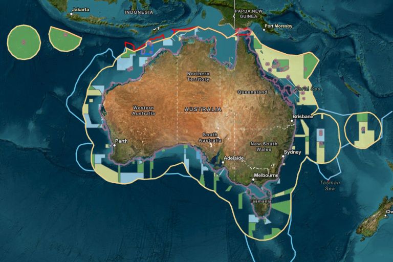
AMSIS connects geography with legislation, maritime boundaries and regulatory frameworks, providing an accessible, trusted view of what applies where across Australia’s marine domain.
International laws and Australian legislation provide the legal framework that defines Australia's maritime boundaries, maritime zones and rights at sea.
Australia's maritime zones are measured from the territorial sea baseline under the UN Convention on the Law of the Sea. Establishing baselines relies on geoscience, geospatial science, coastal mapping and law.