News
2015 GovHack winners announced
Published:7 September 2015
Geoscience Australia is proud to support the principle of open data by sponsoring GovHack 2015, which saw teams from across Australia and New Zealand compete to develop new applications using open Government data.
As part of its contribution to the annual competition, Geoscience Australia offered key datasets and together with CSIRO co-sponsored the prize for the Best Science Hack. This category encouraged entrants to use government data for great scientific outcomes and to help people engage in, understand and use scientific information in their everyday lives.
As the national geoscientific agency, Geoscience Australia provides stewardship of a vast range of data that supports decision making, including in the management of Australia's precious water resources, hazard modelling for safer communities and exploration for mineral and petroleum resources.
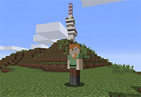
The winner of the GovHack 2015 Geoscience bounty prize was the Minecraft Your City project, created by the Mind The App team, which developed a proof-of-concept topographic map of Canberra using datasets provided by Geoscience Australia and CSIRO. Minecraft Your City also received an honourable mention for the Best Science Hack, which was ultimately awarded to the Saint Simon team for its Lungs project.
Minecraft Your City builds upon actual topographical data enabling the user to enter a virtual environment that simulates the real world. The Minecraft Your City map prototype is playable within the popular Minecraft game and includes Canberra landmarks that help users to gain their bearings. It is a fun, engaging and educational tool that provides an avenue for making geoscience data accessible to the public.
Other successful projects included the Disaster Master entry, which was highly commended for its excellent use of data from data.gov.au and Geoscience Australia's Sentinel Hotspots. It provides a collation of current and past open source data on natural disaster events in Australia, based on their hazard category, impact and geographic location.
The ambitious Virtual RADelaide concept was also highly commended. This project combines data from a variety of sources, including Geoscience Australia's 1-second Digital Elevation Data Model. The project provides a 3D model of a 30 square kilometre area covering the city of Adelaide. The model can also be visualised with the Oculus Rift virtual reality headset.
Several Geoscience Australia staff received the local Canberra Spirit of GovHack Award in recognition of their efforts as volunteer data mentors during the GovHack weekend event.
Email:


