


Geoscience Australia's Antarctic heroes

4 June 2015
Chris Carson and Jane Black
Geoscience Australia and its predecessor organisations have a long and rich history of contributing to the mapping and exploration of Antarctica.
To celebrate this contribution, the names and stories from Geoscience Australia's dynamic past have been revived with a new interactive web map, which enables visitors to rediscover Geoscience Australia's legacy and contribution to the mapping of the Antarctic continent.
Antarctic exploration with distinct geological flavour
During the post-war period, Australia established three Antarctic research stations on the coast of the Australian Antarctic Territory (AAT), namely Mawson (1954), Davis (1957) and Casey (1959). The AAT had previously been claimed by the renowned Australian geologist Sir Douglas Mawson but little was known or mapped across this vast region - an area 77 per cent of the size of Australia and covering some 6 million square kilometres. These research stations provided the essential stepping stones for Australian interests within the AAT to be more readily achieved and realised.
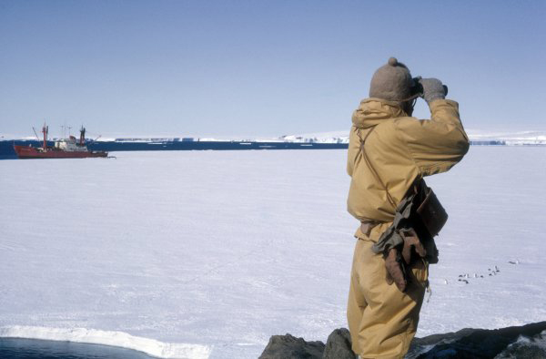
Geologist P. J. Cook inspecting the
sea ice in the vicinity of the Jaeger Islands,
1965. The MV Nella Dan in background.
Photo: I.R. McLeod
In order to establish Australia's presence in the AAT and to provide a foundation for future scientific endeavours, a concerted effort was undertaken to survey and conduct topographic and reconnaissance geological mapping across the AAT. Working in collaboration with the Australian Antarctic Division, Geoscience Australia and its various predecessor organisations including the Bureau of Mineral Resources (BMR), Australian Geological Survey Organisation (AGSO) and Australian Surveying and Land Information Group (AUSLIG), were instrumental in those efforts during the period between the 1950s and the 1980s. These efforts were the stuff of legends, with large areas accessed by dog sledges led by hardy field parties, which operated for months at a time in difficult conditions. These teams mapped, surveyed and studied the geology and geography across vast and remote regions, many of which had never before been explored.
Geographical place names
A particularly exciting legacy of these efforts, not well appreciated outside the Antarctic geoscience community, is that many geographical features such as mountains, islands and lakes are named after the Geoscience Australia pioneers of Antarctic mapping in the modern era.
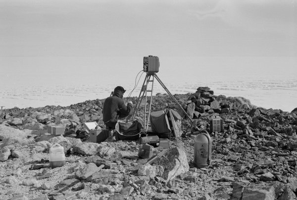
Surveying the Antarctic sea ice, on
the eastern shore of Amery Ice
Shelf between Landing Bluff and
Gillock Island 1969.
Photo: John Bain.
Many of the geographical features were named after personnel actively involved in field programs under the Australian National Antarctic Research Expeditions between 1947 and1966. These included the BMR geologists Ian R. McLeod, Dave S. Trail and John W. Sheraton, whose namesakes include the McLeod Massif, Mount Trail and the Sheraton Glacier. Many of the dedicated surveyors from the Division of National Mapping, later to become AUSLIG, are also represented in the naming of features. Arguably some of Australia's most influential Antarctic surveyors were honoured; examples include research station leaders such as Sydney (Syd) L. Kirkby, after whom Mount Kirkby and Kirkby Head were named, whilst Manning Massif was named for John Manning, surveyor-in-charge of several major field survey operations.
Also honoured with geographic feature names were Earth scientists such as the renowned exploration geophysicist Jack Rayner, after whom the Rayner Glacier is named; past directors of Geoscience Australia's predecessor organisations, such as Sir Harold Raggatt, after whom the Raggatt Mountains were named; and leading map makers and cartographers such as Bruce P. Lambert whose namesake, the Lambert Glacier, is the largest glacier system in the world. Through their crucial leadership and scientific work, such luminaries would transform Australia's knowledge of the Antarctic continent.
Doc Fisher Library Antarctic resources
This rich history of Antarctic geoscience exploration, mapping and research is housed in Geoscience Australia's N H (Doc) Fisher Geoscience Library - home to a wealth of resources chronicling Australia's ongoing involvement in Antarctica. Since 1947 when members of the BMR joined the first Australian National Antarctic Research Expedition (ANARE) to the sub-Antarctic, over 180 publications on the sub-Antarctic and Antarctic regions have been produced. These publications have been digitised and are available for free download via the Library's Legacy Publications webpage.
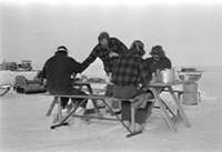
Antarctic expeditioners take a break
for a meal during fieldwork, 1976.
Photo: John Sheraton.
In addition to these publications, the Geoscience Australia Library also holds a unique collection of Antarctic field notebooks. These notebooks contain the original observations made by geologists, surveyors and geophysicists as they commented on the landscape, collected rock samples and sketched the terrain. Also contained in these notebooks are mentions of daily life such as the WYSSA telegraphic codes, used by expeditioners and their families to communicate across the vast distance back to Australia.
Further Antarctic resources housed at Geoscience Australia include air photos, rock samples, photographs, maps and a range of international publications. These resources are accessible to the public in a variety of formats and can be further explored through the N H (Doc) Fisher Library catalogue.
Further information:
- Geoscience Australia's current Antarctic Geoscience program
- Geoscience Australia's interactive Antarctic place names map
You need to upgrade your browser and have javascript enabled to view this video.
A short video [04:36] explaining Antarctic geoheritage and work undertaken by Geoscience Australia and partners in the Larsemann Hills in east Antarctica.