


Improving access and quality of Australian flood information
15 May 2015
The following article provides an overview of Geoscience Australia's work being highlighted at the Floodplain Management Association National Conference being held in Brisbane, 19-22 May 2015.
Geoscience Australia is working with all levels of Australian government to improve the quality, availability and accessibility of flood information.
Natural disasters have a significant impact on Australia's economy, the environment and society. Floods, bushfires, cyclones and earthquakes result in loss of life, property and infrastructure, and damage our natural environment. Although we cannot prevent natural disasters, Australia can improve community resilience through effective preparation, monitoring and response. Geoscience Australia provides essential information to each of these efforts to ensure Australia's community safety.
Following the devastating floods across Eastern Australia in 2011, the Australian Government initiated the Natural Disaster Insurance Review. This review highlighted the lack of consistency in the way flood risk information was collected, and made available to users.
In response to these findings, the Australian Government established the National Flood Risk Information Project (NFRIP). NFRIP commenced in July 2012 and has been funded by the Australian Government for four years. The project aims to improve the quality, availability and accessibility of flood information across Australia, and raise community awareness of their flood risk.
The NFRIP work undertaken by Geoscience Australia provides expert advice and coordination of the following three core projects.
Australian Flood Risk Information Portal
The Australian Flood Risk Information Portal (AFRIP) has been built and provides a free centralised repository of flood studies. This portal makes it easier for the public, engineering consultants, insurers and planners to find out what flood mapping information exists and where, and to facilitate better understanding of local and regional flood risk.
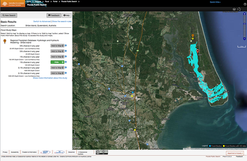
Search results from AFRIP
showing an example flood study
The main catalogue of flood information is available through the portal. Information in the portal can be searched and accessed by all users, but only registered users can add flood studies and associated maps to the database.
AFRIP enables users to learn quickly, from a single source, what work has been undertaken previously in their area of interest, and to identify what data may be available for use in future studies. AFRIP also enables organisations seeking to commission a flood study to learn from work that has been undertaken in other regions.
Contributing flood studies will improve our understanding of flood behaviour at a regional scale, as floods do not respect jurisdictional boundaries, to support emergency management planning. Owners of flood studies can work with Geoscience Australia to contribute their flood study reports and related spatial data such as flood extent, depth and velocity of flood water.
Water Observations from Space
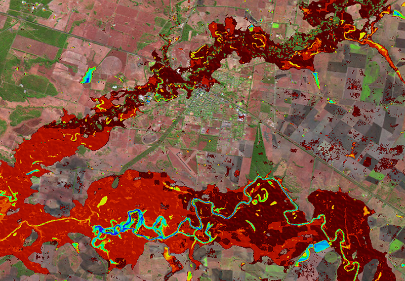
WoFS results over Chinchilla in
southern Queensland showing
neighbouring rivers occasionally
flooding enough to inundate the
town itself (red areas)
The Water Observations from Space (WOfS) project uses Geoscience Australia's Landsat satellite imagery archive from 1987 to March 2014 to provide an indication of how often surface water has been observed anywhere in Australia over the period of the archive. With the entire archive of information now available through WOfS, future imagery captured are updated on a quarterly basis.
This provides baseline information that can be used when no other flood study information is available. WOfS also supports understanding of where surface water may impact infrastructure and can show the effect of structural flood mitigation measures.
Australian Rainfall and Runoff Guidelines
The Australian Rainfall and Runoff (ARR) is a series of national guidelines and datasets fundamental for flood modelling. It is used to estimate design flood characteristics in Australia. The guidelines were last updated in 1987 and modified in 1997.
The ARR is currently being revised by Engineers Australia and with funding provided through NFRIP. The revised guidelines will provide consultants and local government engineers/consultants with the guidance and datasets necessary to produce more accurate and consistent flood studies and mapping into the future. The revision is due for completion by 2015.