


Minerals Alert November 2013
A monthly online newsletter with product news, data releases and projects relating to the minerals and energy exploration industry.
- Australian geological provinces - dataset release version 2013.01
- Upcoming release: A Review of Australian Salt Lakes and Assessment of their Potential for Strategic Resources
- Upcoming release: Nd model age map of the Australian continent
- Upcoming release: New tectonic map of Australia
- Update on geophysical data releases
- About Minerals Alert
1. Australian geological provinces - dataset release version 2013.01
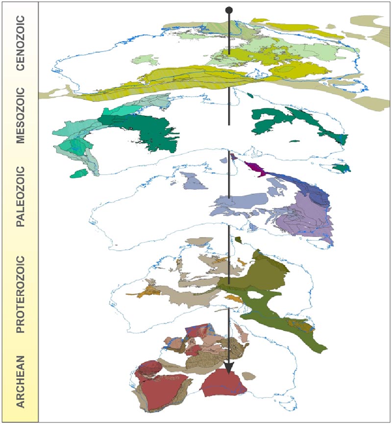
Geological Provinces in Australia.
Geoscience Australia has just released the 2013 preliminary edition of its Australian Geological Provinces dataset. The dataset contains descriptions and spatial extents of the fundamental geological elements of the Australian continent and its offshore surrounds. Province types include sedimentary basins, tectonic provinces such as cratons and orogens, igneous provinces and metallogenic provinces.
The spatial data has been captured mainly at 1:1M scale for intended use at 1:2.5M or less. The full 2D spatial extent of each province has been captured, including the extent of a province under any overlying cover material. The extent of outcrop of many provinces has also been captured. Where possible, the full extent outlines of provinces have been attributed with information about the source, accuracy and observation or interpretation method of those lines. The new dataset replaces Geoscience Australia's 1998 Australian Sedimentary Basins map and supersedes the previous incomplete 2004 dataset.
Where possible, the provinces have been attributed with their age, geological history, contained lithostratigraphic units, relationships to other provinces and mineral resource occurrences, as well as selected published references. The geological definition of some provinces is contentious. Although every effort has been made to achieve a consensus definition and extent of each province, including significant collaboration with state and territory geological surveys, scientific debate could still occur about the nature and extent of some provinces.
Note: This preliminary edition (2013.01) of the dataset is NOT a complete representation of all of Australia's geological provinces, but is the most comprehensive national dataset available. Additionally, not all the provinces descriptions have undergone a rigorous quality assurance check to ensure the accuracy and completeness of their descriptions. Further work is underway in cooperation with the state and territory geological surveys to compile a complete national coverage for all of Australia's geological provinces.
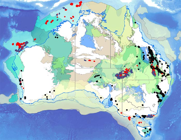
Selected Neoproterozoic to
Cenozoic sedimentary basins,
showing locations of coal (black),
oil (blue) and gas (red) resources.
The Australian Geological Provinces dataset is available in shapefile and ESRI geodatabase formats for free download.
2. Upcoming release: A Review of Australian Salt Lakes and Assessment of their Potential for Strategic Resources
A Review of Australian Salt Lakes and Assessment of their Potential for Strategic Resources report (Geoscience Australia Record 2013/39) will be released shortly. The record contains a comprehensive review of the publicly available knowledge of Australian salt lakes and an assessment of 1200 Australian lakes for the economic recovery of lithium, boron, potash and other commodities. The report is accompanied by GIS datasets and four A0 maps that detail regions which have the highest potential for these strategic commodities based on a mineral systems analysis. The maps also highlight new greenfields areas which may be favourable for the production of these commodities.
3. Upcoming release: Nd model age map of the Australian continent
The first isotopic map of the Australian continent will be released shortly. The map is based on the Sm-Nd isotopic signature of felsic igneous rocks, providing a proxy that allows regional-scale mapping of the crust and crustal growth. The record, with accompanying downloadable isotopic datasets and images, details the theory behind the methodology, the advantages and disadvantages of the technique and provides comparisons between the isotopic map and current knowledge of Australian crustal blocks and tectonics. It also investigates the potential of the isotopic map for identifying metallogenic regions, with examples regarding nickel, volcanic-hosted massive sulphide, iron oxide-copper-gold and porphyry copper-gold mineral systems.
4. Upcoming release: New tectonic map of Australia
A new GIS map layer of major Australian tectonic boundaries will be released soon. The map is based on interpretation of the numerous deep seismic reflection profiles which transect the continent along with geological and geophysical data. The map shows the locations of inferred ancient plate boundaries and provides constraints on the three dimensional architecture of Australia. It will provide helpful information also for mineral explorers investigating areas for potential investment.
5. Update on geophysical data releases
Geoscience Australia is managing the geophysical data acquisition programs in Western Australia, South Australia and the Northern Territory.
The current status of Geoscience Australia's geophysical survey data acquisition is available in a comprehensive table.
Minerals Alert Geophysical Surveys Table - survey boundary polygons in MapInfo TAB format.
6. About Minerals Alert
For more information, please email clientservices@ga.gov.au; or phone 1800 800 173.