


News
Applying science to build community resilience against tropical cyclones
Published:1 November 2018
Applying science to build community resilience against tropical cyclones
Geoscience Australia today released the first update to the Tropical Cyclone Hazard Assessment (TCHA) since 2014.
Atmospheric Hazards Activity Leader Craig Arthur said the 2018 update includes new methodology that better calculates the likelihood of tropical cyclones in Australia.
"The new methodology provides a more realistic evolution of tropical cyclones over their lifetime and an improved understanding of how they weaken once they make landfall," Mr Arthur said.
The TCHA defines the severe wind hazard posed to Australia based on the frequency and intensity of tropical cyclones making landfall around the Australian coastline. Following the 2018 update, it now includes data on 160,000 tropical cyclone scenarios for 400 locations around Australia.
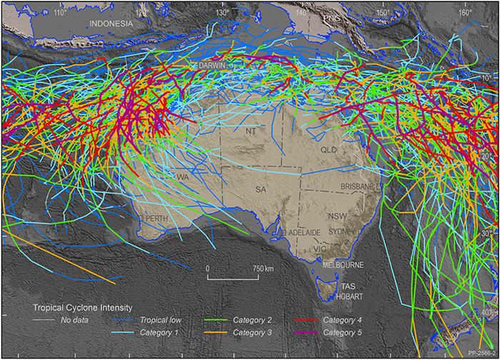
Historical tropical cyclone activity in the Australian region, 1981-2017.
Mr Arthur said there were no surprises when it came to the regions identified as being at higher risk to tropical cyclone hazard. For the 500-year average recurrence interval in the building code, the highest hazard area in Australia is along the Pilbara coastline, near Karratha in Western Australia, where the wind speeds are estimated to have the potential to exceed 250 kilometres per hour, equivalent to a category four tropical cyclone.
"The latest update also highlights in rare cases, the tropical cyclone hazard area can extend further south along the east coast into New South Wales and along the west coast, as far south as Perth."
Mr Arthur said the data in the TCHA is used by Geoscience Australia and other organisations to develop cyclone hazard and impact models, which inform evidence-based disaster management and evacuation plans, as well as infrastructure planning and mitigation strategies.
The TCHA provides vital information to emergency managers, infrastructure owners, town planners and engineers to plan for and reduce the threat of tropical cyclone hazard on the Australian coast. It also supports the insurance and reinsurance industry to understand the tropical cyclone risk as an input to pricing insurance premiums.
"One example of how data from the TCHA is used is our three year project with the Western Australia Department of Fire and Emergency Services to explore the state's vulnerability to severe wind events. As part of this project, four regional centres were chosen for further tropical cyclone hazard analysis; Broome, Port Hedland, Karratha and Exmouth.
"Geoscience Australia will model the impacts of category three and five tropical cyclones on these areas to assess the potential physical damage to buildings and critical infrastructure. Additional impact assessments will also be undertaken for Perth, Geraldton and Carnarvon."
"Science and technology is constantly evolving and improving and we regularly update the assessment to make sure it reflects these advancements."
Further information:
Contact:
Phone:
Email: