


News
Life in icy waters: using geoscience information to protect life on the Antarctic seafloor
Published:25 August 2014
Life in icy waters: using geoscience information to protect life on the Antarctic seafloor
Dr Alix Post
Many parts of the Earth's oceans remain unexplored. This is particularly true for the oceans off the Antarctic margin where thick ice cover, climate extremes and remoteness make exploration even more challenging. Work by marine geoscientists from Geoscience Australia is helping to improve understanding of the unique communities of organisms that live on the Antarctic seafloor.
Physical attributes of the seafloor can be used to help predict the nature and distribution of these biological communities. Depth, geomorphology (shape) and sediment characteristics of the seafloor are particularly significant for characterising seabed habitats.
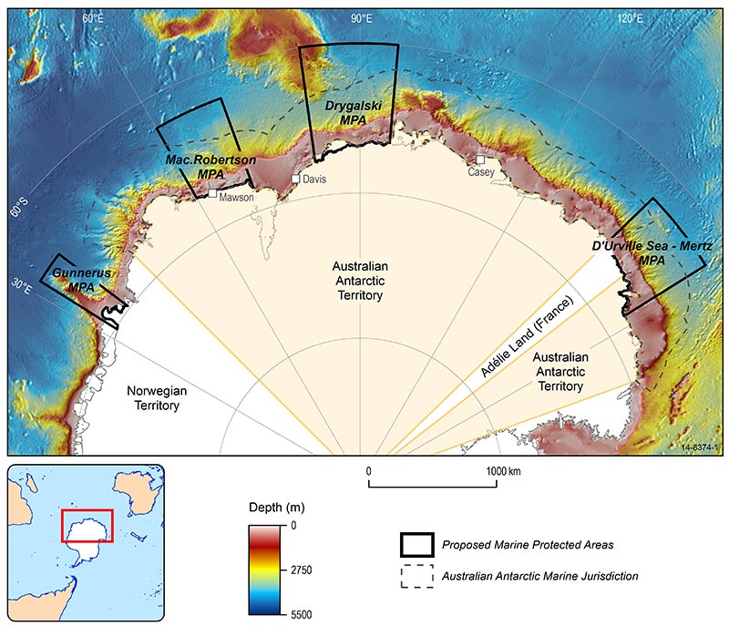
Figure 1: Location of proposed Marine
Protected Areas on the East
Antarctic margin.
Recent work by Geoscience Australia is contributing to the marine planning process within the East Antarctic region, including Australia¿s Antarctic Marine Jurisdiction (AAMJ). The AAMJ covers a vast area of 2.2 million km2 in East Antarctica (Fig 1). The seafloor within the AAMJ supports a stunning diversity of life; however, there are large areas that remain completely unknown from a biological perspective. Datasets of the physical attributes of the seafloor do exist, and have been used to help predict the biotic diversity.
To help to protect the marine biodiversity of the region, a network of four Marine Protected Areas (MPAs) is currently under consideration by the Commission for the Conservation of Antarctic Marine Living Resources (CCAMLR). The proposed network of MPAs is based on analysis of broad scale physical datasets, and aims to support CCAMLR's conservation objectives of protecting representative ecosystems and the region¿s unique biodiversity. The four MPAs contain a diverse array of seafloor habitats, which likely support diverse communities that have been shown to broadly represent the East Antarctic region.
Physical datasets informing our knowledge of seafloor habitats
Physical datasets are important for understanding the nature and distribution of seafloor habitats, particularly in areas where biological sampling is sparse. At Geoscience Australia, bathymetry datasets have been applied to understand depth zonation of habitats, but more importantly the geomorphology (or shape) of the seafloor, while sediment composition and character is used to understand the nature of the seabed substrate.
Geomorphic features, such as banks, basins, seamounts and canyons have been shown to be important factors influencing the distribution and diversity of biological communities on the seafloor. Geomorphology can be related to major habitat characteristics including:
- Seafloor type (hard versus soft)
- ocean current flow regimes
- biodiversity hotspots.
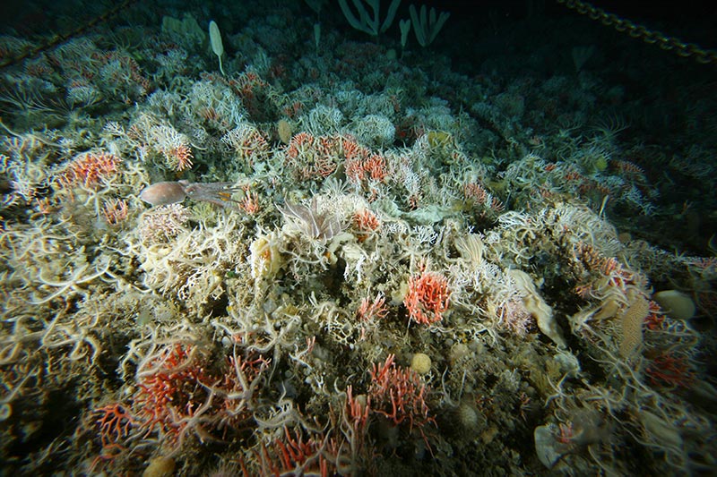
Figure 2: Diverse hydrocoral, sponge
and bryozoan community within a shelf
cutting canyon on the East Antarctic
margin. Photo credit: Australian
Antarctic Division.
Examples of the effects of geomorphology on ocean currents include diversion of currents around or over seamounts and through submarine canyons. Seamounts are well known as biodiversity hotspots due to the availability of hard substrates and complex current flow, which may enhance the nutrient and food supply to the benthos. Submarine canyons have also been identified as significant features on the Antarctic margin, with dense, species-rich communities of hydrocorals, sponges and bryozoans found to be associated with shelf cutting canyons on the continental slope [1] (Fig 2). Geomorphic features have been mapped at a broad scale for the entire Antarctic margin [2] (Fig 3), enabling detection of areas of high conservation value.
Sediments collected from the seafloor are routinely analysed by marine geoscientists to determine the nature and composition of the substrate. The grainsize of marine surface sediments has been shown to have important implications for the distribution of seafloor communities. Areas consisting of soft sediments are often associated with mobile deposit and detritus feeding communities such as holothurians (sea cucumbers) and brittle stars, while areas of sandy to gravelly sediments have higher abundances of attached filter feeding organisms such as sponges and bryozoans. Sediment data has been compiled for the East Antarctic margin from databases and sediment archives to contribute to our understanding of the sedimentary environments within the AAMJ [3].
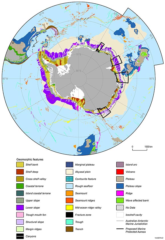
Figure 3: Geomorphic features
mapped for the Southern
Ocean and Antarctic margin.
Marine planning supported by the evidence
The proposed MPAs were selected based primarily on the characteristics of the bathymetry and geomorphology to ensure representation of the biotic diversity contained more broadly within the surrounding marine ecosystems. The recent compilation of seabed sediments provides an additional data layer for assessing the nature of habitats within and outside of the MPAs.
These three datasets: depth, geomorphology and sediment type, indicate that the four MPAs contain a diverse range of seabed environments, which includes deep muddy basins, iceberg-scoured sandy shelf banks, ruggedly eroded slope canyons, a seamount and muddy deep sea plains. The diversity of physical environments within the proposed MPAs suggests that they likely support a diverse range of seabed communities.
The physical features of areas within and outside of the proposed MPAs have been compared to assess how well the MPAs would represent the physical habitats within the broader East Antarctic region. This analysis indicates that habitat features of the East Antarctic margin are reasonably well represented within the four proposed MPAs in terms of sediment type, water depth and geomorphic features.
All sediment types and water depths within the 0 to 5000 metre range are well represented within the proposed MPA network. Further to this, at least 15 per cent of each of the main geomorphic features found in the region are contained within the MPAs. Features of known high conservation value, such as canyons and seamounts, are well represented, with 30 per cent and 50 per cent of the occurrence of these features from the East Antarctic region contained within the proposed MPAs.
Some geomorphic features with a low occurrence across the region are poorly represented or absent within the proposed MPAs. These features include areas of rough seafloor, seamount ridges and marginal plateaus. Further assessment of biodiversity within these habitats is needed to determine the potential impact of not having these features represented within the MPA network. In further work we hope to expand our understanding of seabed environments in areas where we have less information.
The next opportunity to progress the East Antarctic MPA proposal will be at the annual meeting of CCAMLR in Hobart in October 2014.
Distinguished Geoscience Australia Lecture
A webcast of Dr Alix Post's Distinguished Geoscience Australia Lecture is available for on-demand viewing.
References
[1] ^Post, A.L., O'Brien, P.E., Beaman, R.J., Riddle, M.J., De Santis, L., 2010. Physical controls on deep-water coral communities on the George V Land slope, East Antarctica. Antarctic Science 22, 371-378, doi:310.1017/S0954102010000180.
[2] ^O'Brien, P.E., Post, A.L., Romeyn, R., 2009. Antarctic-wide geomorphology as an aid to habitat mapping and locating Vulnerable Marine Ecosystems, Commission for the Conservation of Antarctic Marine Living Resources Vulnerable Marine Ecosystems Workshop, Paper WS-VME-09/10. CCAMLR, La Jolla, California, USA.
[3] ^Post, A.L., 2013. A compilation of grainsize, biogenic silica and carbonate data from East Antarctic surface sediments, Geoscience Australia, Record 2013/05, p. 60.
Contact:
Phone:
Email: