


News
New geophysical data for CO2 storage and hydrocarbon prospectivity in the Browse Basin
Published:27 June 2014
New geophysical data for CO2 storage and hydrocarbon prospectivity in the Browse Basin
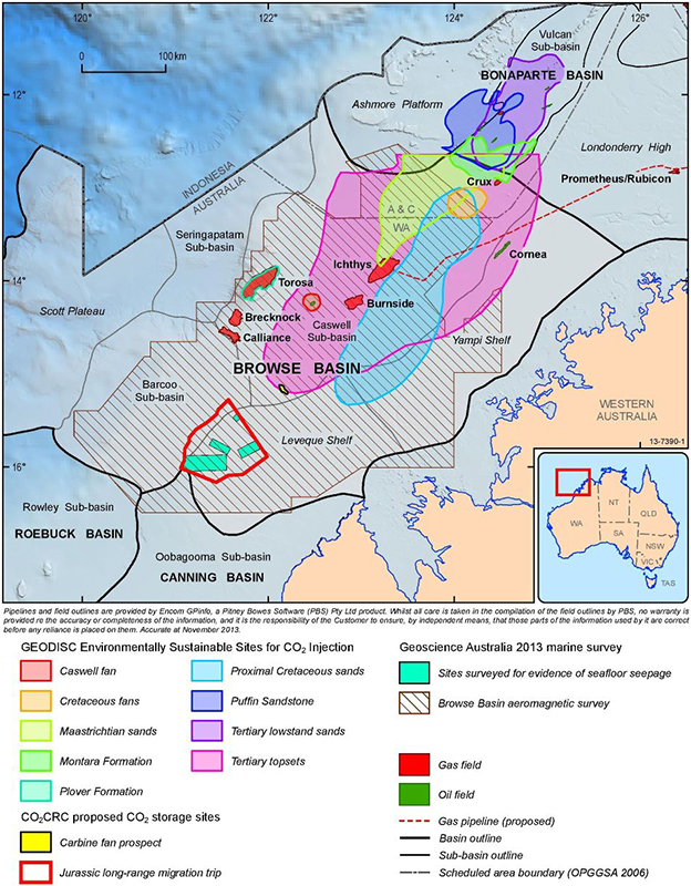
Figure 1: Map of the Browse
Basin showing the main
structural elements of the
basin, some previously
identified areas of interest
for CO2 storage prospects
[5], the areas surveyed
during the Browse Basin
2013 marine survey [3]
and the outline of the new
airborne magnetic data
acquired in 2013.
Ron Hackney and Marina Costelloe
Government-funded pre-competitive regional-scale airborne magnetic data have an important role to play in helping to understand energy and mineral systems. The data help to reduce exploration risk and provide a framework for detailed studies that seek to identify energy and mineral resources.
Recognising the benefits of airborne magnetic data to regional basin studies, an airborne magnetic survey was conducted during 2013 in the Browse Basin off the northwest coast of Western Australia. The survey was conducted as part of the National CO2 Infrastructure Plan that aims to acquire, interpret and integrate new and existing pre-competitive data to assess the suitability of various basins for the geological storage of carbon dioxide (CO2). The new data, recently released online, will also be merged with existing data to produce updated national magnetic anomaly maps that will help future resource exploration.
Obtaining airborne magnetic data is a cost effective and quick way to provide information on important characteristics of sedimentary basins; these can include sediment thickness, fault architecture, distribution of volcanic rocks and basement composition. These characteristics influence the hydrocarbon prospectivity of a basin and its potential to store CO2.
Understanding sediment thickness is important because hydrocarbons will not be generated unless organic-rich source rocks are deep enough to be sufficiently heated for the necessary chemical reactions to occur.
Faults within a basin govern the space available for sediment accumulation and provide evidence of the basin's tectonic evolution. Faults can also influence the migration of hydrocarbons from source to reservoir and affect whether or not the geological seal above a reservoir retains its integrity, thereby ensuring that hydrocarbons or CO2 remain in the underlying reservoir. When faults cut through a geological seal above a potential reservoir, the seal can be breached and, depending on the permeability of the fault, CO2 or hydrocarbons in the underlying reservoir may migrate into overlying rock formations.
Better knowledge of the distribution of volcanic rocks is also a key part of assessing the suitability of any given reservoir for holding CO2 or hydrocarbons. If a reservoir is adjacent to or contains volcanic rocks, the reservoir's storage capacity could be reduced by mineral precipitation within pore space. This precipitation arises from the chemical reactions driven by the heating and fluid flow induced at the time the hot volcanic rocks were emplaced.
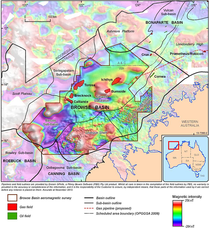
Figure 2: Map of the Browse
Basin showing the main
structural elements of the basin
and a preliminary merge of the
new airborne magnetic data
acquired in 2013 with existing
ship-track and airborne
magnetic data.
Information on these features can be gained from magnetic data because magnetised rocks perturb the Earth's magnetic field in a measurable way. When corrections are applied to the data that account for the magnetic field arising from flow in the molten-iron outer core and the interaction of the solar wind with the ionosphere, the remaining (residual) magnetic field reflects the distribution of magnetised rocks within the Earth's crust.
Thomson Aviation were contracted to acquire the new magnetic data over the Browse Basin. From late August to early November 2013, two aircraft acquired about 190,000 line kilometres of data along north-south traverses spaced 800 metres apart, east-west tie lines spaced 4000 metres apart, all at a nominal flying height of 80 metres above sea level [1].
Browse Basin Study
The Browse Basin (Figure 1) is a northeast-trending Paleozoic to Cenozoic depocentre located offshore in the Timor Sea region of Australia's North West Shelf. The basin contains a Paleozoic, Mesozoic and Cenozoic sedimentary succession in excess of 15,000 metres thick. The main structural elements of the basin include the Barcoo and Caswell sub-basins and the Leveque and Yampi shelves in water depths that reach about 2000 metres. The outboard and frontier parts of the basin include the Scott Plateau and Seringapatam Sub-basin in water depths of up to 5000 metres.
The Caswell Sub-basin hosts several large gas fields planned for Liquefied Natural Gas (LNG) and condensate development. Gas accumulations in the Browse Basin are naturally high in carbon dioxide (CO2). Initial assessment undertaken by the Carbon Storage Taskforce indicated that the Browse Basin has significant potential with the capacity to store more than 7GT of CO2 [2]. The Carbon Storage Taskforce assessment also indicated that a detailed study of this basin would be required to underpin any future Greenhouse Gas acreage release in this area. This assessment is being undertaken by Geoscience Australia during 2012-15 as part of an integrated study into the resource potential of the basin.
Geoscience Australia's current focus on the Browse Basin as a potential area for CO2 storage also involves a review of the sequence stratigraphic framework of the basin and analysis of data from a marine survey on the Leveque Shelf [3] that targeted evidence for seafloor seepage over a proposed long-migration dissolution CO2 trap [4] (Figure 1). A similar marine survey is planned for the Caswell Sub-basin in late 2014.
The current work in the Browse Basin is the precursor to further regional studies of the North West Shelf that aim to identify, characterise and map structural events and the structural architecture of North West Shelf basins. This mapping will aid interpretations of the nature of basement, the role of structural inheritance and controls on the distribution of volcanic rocks. The new Browse Basin airborne magnetic data will be a key component of this mapping.
References
[1] ^ Rogerson, P. (2014), Geoscience Australia Project 1258 (G2023AM) Airborne Geophysical Survey Operations and Processing Report: Browse Basin, Thomson Aviation Geophysical Survey, 41pp.
[2] ^ Carbon Storage Taskforce (2009), National Carbon Mapping and Infrastructure Plan - Australia: Full Report, Department of Resources Energy and Tourism, Canberra, 126pp.
[3] ^ Picard, K., et al. (2014), Seabed Environments and Shallow Geology of the Leveque Shelf, Western Australia SOL5754 (GA0340) Post Survey Report, Geoscience Australia Record 2014/10.
[4] ^ Chirinos, A., et al. (2008), Site Characterisation Analysis for Potential CO2 Storage in the Browse Basin, North West Shelf, Australia. Cooperative Research Centre for Greenhouse Gas Technologies, Canberra, Australia, CO2CRC Publication Number RPT08-1014, 139pp.
[5] ^ Bradshaw, J., et al. (2002), The potential for geological sequestration of CO2 in Australia: Preliminary findings and implications for new gas field development, APPEA Journal 42, 25-46.
Contact:
Phone:
Email: