


News
Australia officially moves 1.8 metres northeast
Published:15 December 2017
Australia officially moves 1.8 metres northeast
Australia's coordinates have officially moved 1.8 metres northeast, with Minister for Resources and Northern Australia Matt Canavan today launching Australia's new coordinate reference frame, the Geocentric Datum of Australia 2020 (GDA2020).
While Australians rely on positioning technology every day, they may not know is that a datum is the underlying reference for Australia's coordinates. They may also not realise that the accuracy of this datum is affected by the movement of Australia's tectonic plate which travels around seven centimetres each year; this means Australia's coordinates need to change to keep up.
Australia is currently using a datum from 1994; this is now 23 years old and out of sync with the tectonic plate by 1.6 metres. Modernising the datum enables Australia to embrace a range of applications that depend on precise positioning, like autonomous and remotely-operated systems.
Geoscience Australia's GDA2020 Project Leader, Nick Brown, explains that the updated coordinates are based on the projected position of the Australian continent in 2020.
"As we approach 1 January 2020, the GDA2020 coordinates and the coordinates from global navigation systems, like GPS, will converge. This increased accuracy will benefit a range of Australian industry sectors, with the update particularly relevant to surveying, spatial sciences, mobile location based services and the emerging intelligent transport industry," Nick Brown said.
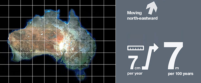 The new Geocentric Datum of Australia 2020 (GDA2020) moves Australia's coordinates 1.8 metres northeast.
"Geoscience Australia and the Intergovernmental Committee on Surveying and Mapping (ICSM) are working closely with government and spatial organisations to support their transition to the new datum. We've developed a series of technical tools and manuals to help these organisations update their spatial datasets."
The transformation support tools include the new ICSM GDA2020 Technical Manual which provides details on the two transformation datasets needed by the spatial information industry; online software (AUSPOS and AUSGeoid2020) and plugins to support the transformation; and a new web service that will transform selected spatial format files from GDA94 to GDA2020 using the transformation grids.
For further information on GDA2020 visit the ICSM website.
More information about transitioning to GDA2020 is available from the Geoscience Australia website.
Contact:
Phone:
Email: