


News
United Nations resolution encourages sharing of geospatial data
Published:20 April 2015
United Nations resolution encourages sharing of geospatial data
Anna Riddell
The United Nations General Assembly recently adopted its first ever resolution recognising the importance of a globally-coordinated approach to geodesy - the scientific discipline that measures changes in the size, shape and gravity field of our planet Earth.
Geodesy provides a coordinate reference frame for the whole planet, allowing us to accurately know within a few millimetres where people and features are on the Earth. Measurement at the millimetre level is required for applications such as measuring global sea level change, while centimetre level positioning is essential for precision agriculture and automated mining, as well as future opportunities such as driverless cars.
All measurements including length, distance, height, location and spatial information need something to be referenced to, and this is what geodesy information provides. All satellite imagery is inherently linked to geodesy by the need to define parameters for "where" and "when" the information is collected. Our economic system also relies on accurate positioning and timing, for example banking and stock exchange timing transfers inherently rely on the on-board atomic clocks of satellites.
The new UN resolution recognised the need for international collaboration on geodesy, including the open sharing of geospatial data, support for development of further capacity-building in developing countries and the creation of international standards and conventions.
The United Nations press release on 26 February 2015 stated that 1:
"The General Assembly resolution, A Global Geodetic Reference Frame for Sustainable Development, outlines the value of ground-based observations and remote satellite sensing when tracking changes in populations, ice caps, oceans and the atmosphere over time. Such geospatial measurements can support sustainable development policymaking, climate change monitoring and natural disaster management, and also have a wide range of applications for transport, agriculture and construction."
A global system for positioning
The United Nations Committee of Experts on Global Geospatial Information Management (UN-GGIM) first decided in July 2013 to formulate and facilitate a resolution for a global geodetic reference frame. The UN-GGIM recognised the growing demand for more precise positioning services, the economic importance of a global geodetic reference frame and the need to improve the global cooperation for international geodesy.
Positioning services around the world rely on the guaranteed availability of and access to a high quality global coordinate system; utilised in applications such as land titling and ownership, engineering construction, precision agriculture, intelligent transport, navigation, geodynamics and other geoscientific studies, including climate change and sea level monitoring. The International Terrestrial Reference Frame (ITRF), in place since 1988 2, provides this global coordinate system.
With each new version of the ITRF, improvements are made as instrumentation is upgraded due to technological advancement and as the time span of data increases, allowing a greater understanding of the changes of the Earth over longer lengths of time. The UN resolution calls for a Global Geodetic Reference Frame (GGRF), which will improve the ITRF through stronger international collaboration.
The recognition provided by the UN General Assembly resolution builds upon the solid base provided by the ITRF and will ensure that a GGRF continues to improve and support fundamental science that hinges upon the reliability and accuracy of a GGRF.
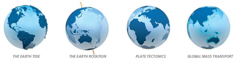
The Earth is a dynamic planet in constant motion. Geodesy monitors the difference processes that cause these motions.
Image: UN-GGIM/GGRF Working Group
'No country can do this alone'
The whole geodesy network is underpinned by infrastructure that consists of globally distributed geodetic observatories and satellite tracking stations. It is operated by an internationally organised effort of data centres and analysis teams within governments and the scientific community that, on an ongoing basis and often in real-time, provide products, corrections and models that enable the ITRF to function.
Although vitally important to society, this global cooperation currently relies almost entirely on a 'best efforts' principle. The infrastructure is operated by national governments through their national geospatial or space agencies, but a significant proportion of this infrastructure also relies on research organisations and universities which contribute on a research project basis. The UN resolution highlights that a GGRF cannot be sustained by the efforts of individuals, be they people or organisations, and calls for international cooperation on open data sharing; capacity building and global distribution of infrastructure.
The UN resolution ultimately co-sponsored by 52 Member States, was originally put forward by Fiji's ambassador Peter Thomson, Fiji's Permanent Representative to the United Nations. As a Small Island Developing State, Fiji is vulnerable to increasingly severe natural disasters, sea-level rise and other problems triggered by climate change, but uses geodesy data to plan as best as it can. Fiji's government fully realises the importance of critical geospatial infrastructure and information in helping countries and decision-makers make more informed, evidence-based decisions on mitigation and preparedness.
Australia's part to play
The UN-GGIM Secretariat commended the great leadership by Fiji, and the diligent work carried out by the Working Group GGRF led by Australia and Norway. The Australian Government has been represented in this forum by Mr Gary Johnston, Branch Head of Geodesy and Seismic Monitoring at Geoscience Australia, as Co-Chairperson of the Working Group on Global Geodetic Reference Frame. Geoscience Australia will continue to provide leadership to the Working Group in the next phase of activity which will include the development of an international roadmap for action.
Geoscience Australia has contributed directly to the ITRF since 1992 by managing the Australian Regional Global Navigation Satellite System Network (ARGN) and the Asia-Pacific Reference Frame (APREF) Central Bureau, which both have the broad objectives to strengthen the geodetic reference frame in our region.
With the focus of the UN General Assembly resolution on a GGRF for Sustainable Development looking towards multilateral cooperation, open data sharing, and capacity building in developing countries, Geoscience Australia will continue to provide leadership in this area, enabling geodesy to support society.
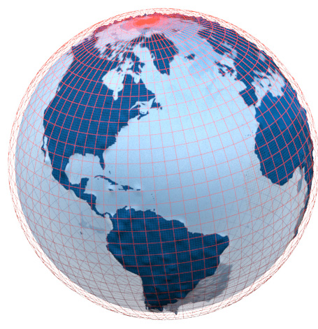
GGRF allows us to know where
people and places are on the Earth.
Image: UN-GGIM/GGRF Working Group
Further information
- Science topic: Geodesy
- Science topic: Global Navigation Satellite System Networks
- Website UN Global Geodetic Reference Frame for Sustainable Development
- The GGRF resolution in all UN official languages
- Short video explaining the Global Geodetic Reference Frame for Sustainable Development [03:00]
- Updates on the UN-GGIM via Twitter @UNGGIM
References
[1]^ United Nations (2015) UN General Assembly urges sharing of geospatial data to benefit people and planet, Press Release (accessed 18 March 2015).[2]^ Altamimi, Z., X. Collilieux, et al. (2011). "ITRF2008: an improved solution of the international terrestrial reference frame." Journal of Geodesy 85 (8): 457-473.
Contact:
Phone:
Email: