


News
World Water Day 2022: Groundwater, making the invisible visible
Published:22 March 2022
World Water Day 2022: Groundwater, making the invisible visible
Today is World Water Day and the theme is ‘Groundwater: making the invisible visible’.
Today is World Water Day and the theme is ‘Groundwater: making the invisible visible’.
Water availability in Australia varies every year and can reach extremes from very dry, to very wet, as we have seen in the recent devastating floods in eastern Australia. Our thoughts and best wishes go out to all those impacted by this recent flooding.
Groundwater in Australia
Geoscience Australia is helping to establish a nationally coordinated geoscientific approach to better understand, manage and secure Australia’s groundwater systems.
Groundwater is critical to Australia’s future economic development. It provides more than 30 per cent of our consumptive water supplies and supports many billions in economic activity each year. It is also important for protecting environmental and cultural assets with groundwater feeding springs that support groundwater dependent ecosystems.
Groundwater is water stored in the cracks and pores of rocks (aquifers) deep in the ground. When rain falls, some water flows across the surface of the land and accumulates in rivers, lakes, and eventually the ocean. But some of the water seeps into the ground and accumulates, forming groundwater resources, which in turn also eventually flow into rivers, lakes or the ocean.
In many parts of Australia, groundwater underpins agriculture, the health of the environment, minerals and energy resource development and community water supplies. In arid Australia, it can be the only reliable source of water available to regional communities and industries. Groundwater also plays a crucial role in sustaining flows in rivers and creeks, particularly during low flow periods. It is also an essential resource that supports Indigenous cultural values and sustains a range of groundwater dependent ecosystems.
Making the invisible visible
Chief of Minerals, Energy and Groundwater, Dr Andrew Heap, said Geoscience Australia, in partnership with Commonwealth, State and Territory agencies, is mapping Australia’s groundwater systems using new technologies and integrated geoscience approaches including satellite data. This mapping helps to make the invisible visible.
“It is vital that we improve the information and knowledge about Australia’s groundwater resources so we can make informed management decisions,” Dr Heap said.
“The demand for groundwater resources in Australia is expected to increase with population growth and economic development.
“Geoscience Australia is undertaking national and regional groundwater investigations, including through the Australian Government’s Exploring for the Future initiative and the Great Artesian Basin groundwater study.
“The studies involve application of innovative geoscience tools and world-class geoscientific workflows to understand groundwater systems and assessment of groundwater resource potential for economies, communities and the environment. The results of these studies are helping water managers to inform management decisions and protect environmental and cultural assets.
“For example, Geoscience Australia’s experts are mapping groundwater resources through satellite data to better understand how water moves through the landscape and recharges underground.
“We recently analysed time-series satellite data from Digital Earth Australia (DEA) to map springs in the Upper Burdekin region of north Queensland.
“DEA’s Waterbodies product identified where waterbodies such, as lakes and dams, are located in the Upper Burdekin, and showed how the wet surface area of each waterbody has changed over the past 30 years.
“Geoscience Australia’s analysis of this information confirmed groundwater is feeding these springs, some of which support groundwater dependent ecosystems and also support the Burdekin River to flow throughout the year.”
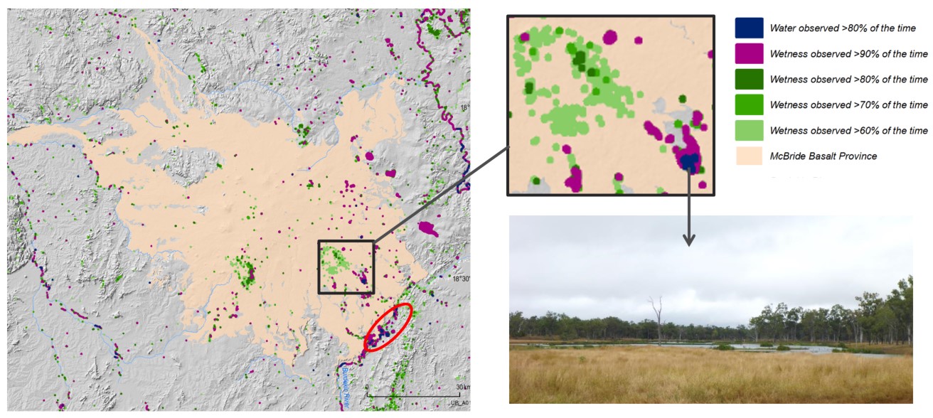
Water observed at Kinrara Lake in the Upper Burdekin region of north Queensland. This satellite data mapped new springs that support groundwater dependent ecosystems
Geoscience Australia’s Strategy 2028 provides a strategic vision for water resources in Australia, focussing on a national integrated geoscientific understanding of Australia's groundwater systems to contribute to national water resource security for industry, environment and the public. This includes understanding the geology, hydrogeology and groundwater resource characteristics of aquifers that hold groundwater and the groundwater recharge and discharge.
More information about how Geoscience Australia supports the securing of Australia’s groundwater resources is available here.
Contact:
Phone:
Email: