


News
First major upgrade to the Australian Rainfall and Runoff Guidelines in 30 years
Published:25 November 2016
First major upgrade to the Australian Rainfall and Runoff Guidelines in 30 years

The Australian Rainfall and Runoff (ARR) Guidelines have undergone their first major update in 30 years. The new guidelines provide a significant improvement in best practice flood modelling, incorporating a series of national guidelines and fundamental datasets for flood modelling across Australia.
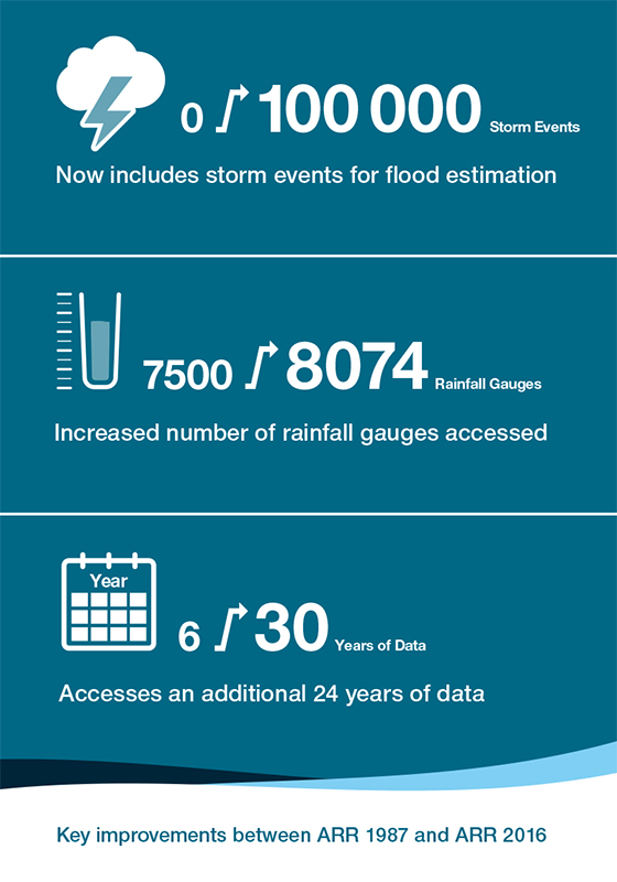
The ARR 2016 is now truly a national product incorporating observations from across the continent and data from a catalogue of over 100 000 storm events, drawing upon an additional 30 years of data. And for the first time, ARR has been based completely on Australian data to better reflect Australia's variable landscape and climate. The modernised guidelines provide engineers and consultants with the necessary guidance and datasets to produce more accurate and consistent flood studies and mapping across Australia, now and into the future.
The ARR guidelines, first published in 1958 and last fully updated in 1987, give engineers the best information on flood estimation. The 1987 edition was republished in 1999, with updates to the chapter on the estimation of extreme to large floods. By the mid-2000s the Australian engineering community formed the view that recent advancements in both technology and the understanding of rainfall-runoff processes required further revisions.
A revision project was first established in 2007 with funding from the Australian Government. However, it was not until the findings of the review into the floods of summer of 2010-11, when south-eastern Australia experienced a significant number of major flood events culminating in the flooding of Brisbane in January 2011, that a project to complete the revision was established.
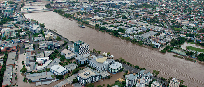 Aerial photo of the Brisbane River during the January 2011 floods. Credit: Brisbane City Council
Guiding best-practice flood planning
Professional engineers and planners, particularly those within local government, are encouraged to make the most of this valuable resource. Broad application and consistent use of ARR will guide development in high flood risk areas and help to ensure that infrastructure is appropriately designed. Better planning gives the wider community the confidence to better understand their flood risk, and inform their options to mitigate this risk.
Keeping the ARR up to date is an important component for providing reliable and robust estimates of flood risk. It also provides necessary information for locating new developments in safer areas, and appropriately designing new infrastructure such as roads and bridges. The digital delivery of ARR 2016 allows minor updates to be made immediately without a complete edition update. When major updates occur, this will be reflected by changing the year in the title.
The updated guidelines also provide a common data standard across jurisdictions to govern a consistent approach to collecting, analysing and managing flood information. The information and approaches presented in the ARR guidelines provide quality guidance for policy decisions and projects involving essential infrastructure such as transport and water, and contribute to more effective town planning and better delivery of flood warnings.
A summary of the key improvements
in the 2016 ARR guidelines
New Intensity-Frequency-Duration design rainfall estimates
The 2016 ARR guidelines also incorporate the new Intensity-Frequency-Duration (IFD) design rainfall estimates released by the Bureau of Meteorology. The new IFD estimates are derived from observations from over 10 000 rainfall gauging stations, including 2300 extra stations and nearly 30 years of additional rainfall data. They are also derived using statistical analysis techniques that weren't available 30 years ago.
IFD estimates use the relationship between the historical observations of how much rain falls, how often and for how long in specific locations to provide an estimate of rainfall intensity or depth for design flood estimation. These estimates are is used by engineers to understand frequency and likely intensity of rainfall them to design better dams, stormwater drainage, to improve floodplain management and assist land managers with soil conservation strategies.
A new era for ARR
Following completion of the review and update, ownership of the ARR has been transferredfrom Engineers Australia to Geoscience Australia on behalf of the Australian Government. Previously accessible only as a book on a fee-for-access basis, it is now publically available online and free of charge under a Creative Commons Attribution 4.0 Licence.
Visit arr.ga.gov.au to learn more about ARR 2016, and sign up to the ARR newsletter to keep informed of updates.
Contact:
Phone:
Email: